






Manila Bulletin
 Philippines
National
'Saudel' to briefly enter PAR; direct impact unlikely as it stays offshore — PAGASA
Philippines
National
'Saudel' to briefly enter PAR; direct impact unlikely as it stays offshore — PAGASA
Philippines
National
'Saudel' to briefly enter PAR; direct impact unlikely as it stays offshore — PAGASA
'Saudel' to briefly enter PAR; direct impact unlikely as it stays offshore — PAGASA
Published Aug 24, 2026 11:23 am


At A Glance
- PAGASA said Typhoon Saudel will be given the local name "Obet" once it enters PAR Monday afternoon, Aug. 24.
- Based on the forecast track, Saudel is expected to exit PAR Monday evening or early Tuesday, Aug. 25.
- PAGASA said Saudel is less likely to directly affect the country's weather and sea conditions over the next three days.
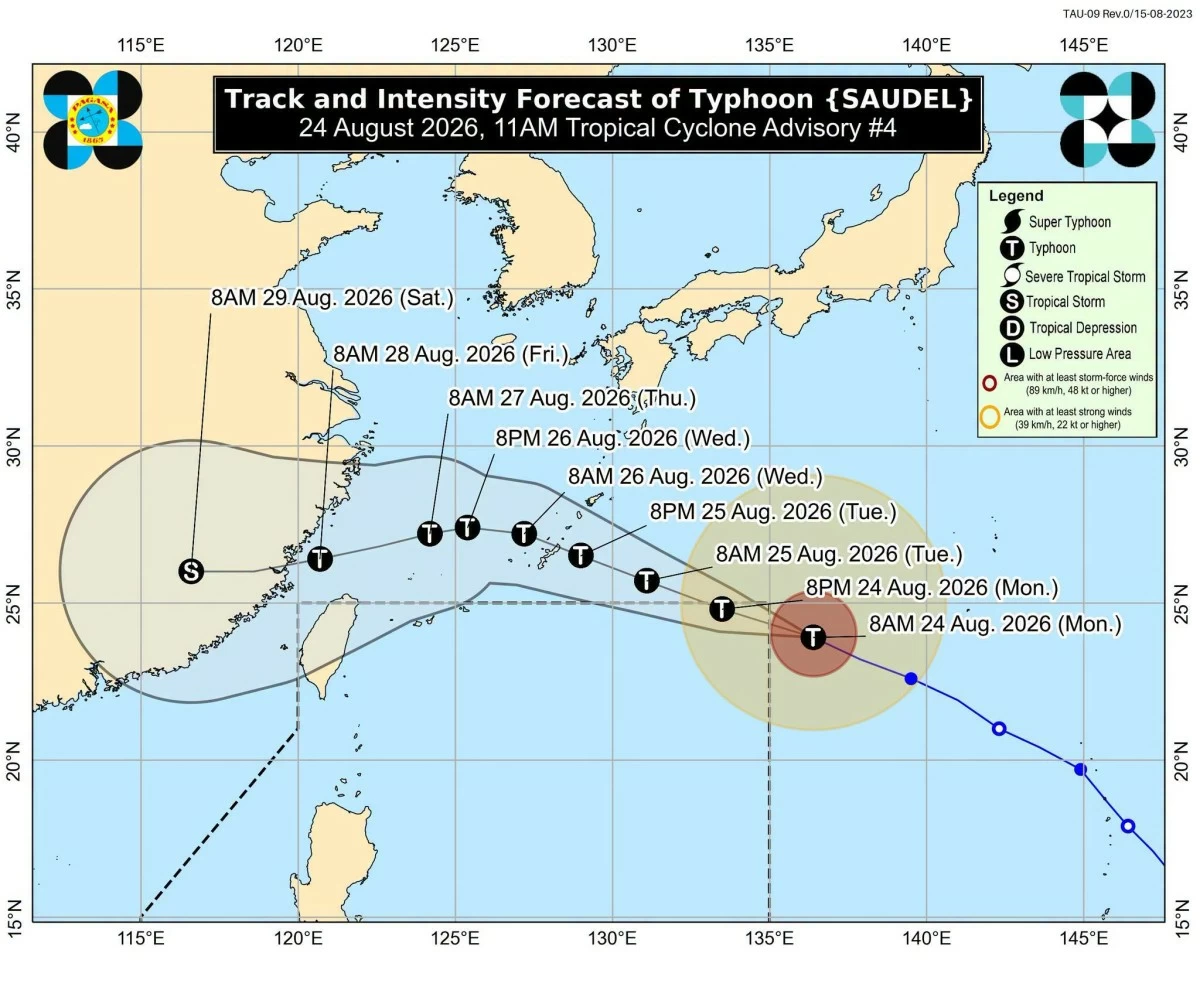
PAGASA
The typhoon with the international name “Saudel” is expected to briefly enter the Philippine Area of Responsibility (PAR) on Monday afternoon, Aug. 24, but will remain far from the country’s landmass, the Philippine Atmospheric, Geophysical and Astronomical Services Administration (PAGASA) said.
As of 10 a.m., the center of Saudel was estimated at 1,480 kilometers east-northeast of extreme Northern Luzon, outside PAR.
PAGASA said the typhoon will be given the local name “Obet” once it enters PAR.
Saudel maintained maximum sustained winds of 175 kilometers per hour (kph) near the center and gustiness of up to 215 kph. It was moving west-northwestward at 30 kph.
The typhoon is currently near super typhoon strength and may intensify further into a super typhoon, with maximum sustained winds of at least 180 kph, before entering or while inside PAR.
However, PAGASA said Saudel is less likely to directly affect the country’s weather and sea conditions over the next three days.
Based on the forecast track, Saudel is expected to exit PAR Monday evening or early Tuesday, Aug. 25.
However, a more westward track beyond the next 24 hours could result in Saudel remaining within PAR beyond Tuesday.
While Saudel is expected to stay offshore, it is enhancing the southwest monsoon or “habagat,” together with Tropical Depression Gaenari, formerly known as “Neneng.”
PAGASA weather specialist Aldczar Aurelio said the habagat is currently affecting Northern and Central Luzon and its effects over Luzon may continue for the next four days.
As of Monday, occasional monsoon rains are expected to persist in Batanes.
Metro Manila, Ilocos Region, Cordillera Administrative Region, Central Luzon, the rest of Cagayan Valley, Cavite, Batangas, and Rizal will have cloudy skies with scattered rains and thunderstorms.
The rest of the country will experience partly cloudy to cloudy skies with isolated rainshowers or thunderstorms.
PAGASA is also monitoring two other tropical cyclones outside PAR.
Tropical Storm Atsani was located 1,535 kilometers east of southeastern Luzon.
It was moving north-northeastward at 10 kph and has a low chance of entering PAR as it interacts with Saudel.
Tropical Depression Gaenari was located 505 kilometers north-northwest of Itbayat, Batanes, and was moving southwestward away from the country.