






Manila Bulletin
 Philippines
National
'Neneng' unlikely to make landfall; another tropical cyclone may enter PAR next week
Philippines
National
'Neneng' unlikely to make landfall; another tropical cyclone may enter PAR next week
Philippines
National
'Neneng' unlikely to make landfall; another tropical cyclone may enter PAR next week
'Neneng' unlikely to make landfall; another tropical cyclone may enter PAR next week
'Habagat' rains to continue before easing by weekend
Published Aug 19, 2026 01:56 pm


At A Glance
- As of 10 a.m., Neneng was located 530 kilometers east-northeast of Itbayat, Batanes, with maximum sustained winds of 55 kilometers per hour (kph) near the center and gustiness of up to 70 kph.
- While Neneng is not expected to directly affect the country, Estareja said it is helping draw the southwest monsoon or "habagat" toward Luzon and the western section of Visayas.
- PAGASA is also monitoring another tropical depression east of Mindanao that could strengthen and enter the Philippine Area of Responsibility (PAR) by early to mid-next week.
PAGASA
Tropical Depression Neneng is not expected to make landfall in the country as it heads toward northern Taiwan, the Philippine Atmospheric, Geophysical and Astronomical Services Administration (PAGASA) said on Wednesday, Aug. 19.
PAGASA weather specialist Benison Estareja said Neneng would continue moving northwestward over the northern Philippine Sea before approaching the northern tip of Taiwan.
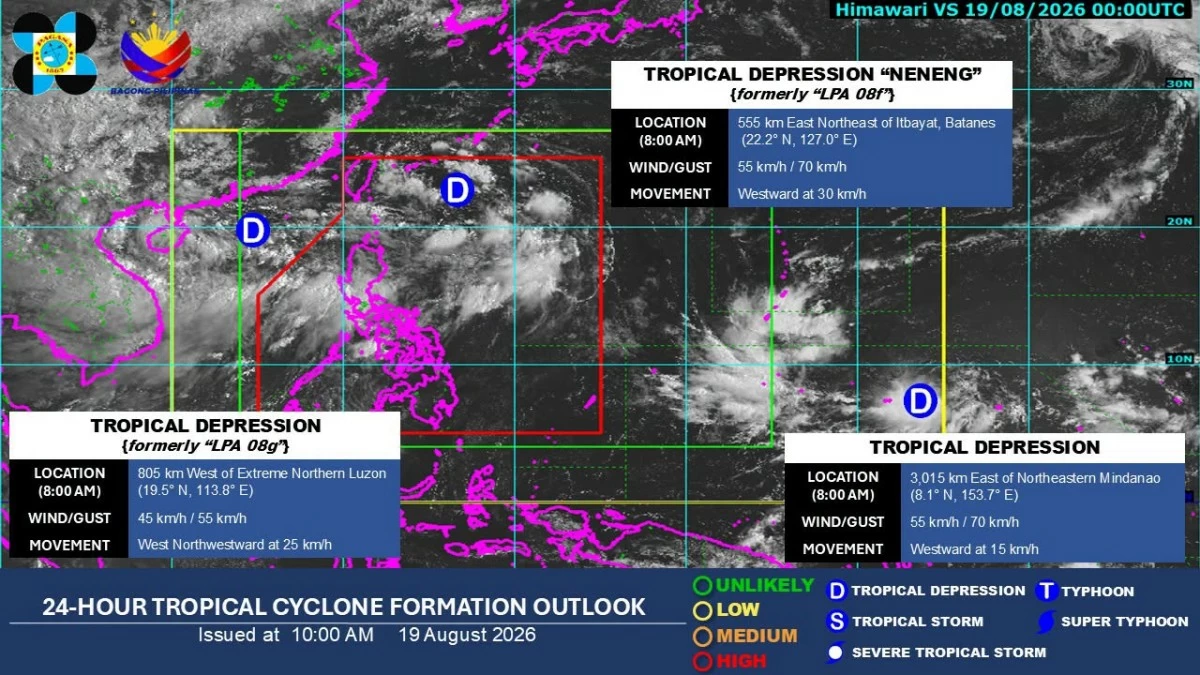
As of 10 a.m., Neneng was located 530 kilometers east-northeast of Itbayat, Batanes, with maximum sustained winds of 55 kilometers per hour (kph) near the center and gustiness of up to 70 kph.
It was moving northwestward at 30 kph.
Estareja said Neneng could either make landfall over northern Taiwan or make a close approach before moving toward the East China Sea.
“So ibig sabihin wala nga pong inaasahang landfall. For now po wala tayong nakataas na tropical cyclone wind signal at in terms of intensity naman, possible siyang manatili pa rin po as a tropical depression within the next one to two days hanggang maging low pressure area na lamang pag-angat po sa ating area of responsibility (This means that no landfall is expected in the Philippines. For now, we have no tropical cyclone wind signal raised, and in terms of intensity, it may remain a tropical depression within the next one to two days before weakening into a low-pressure area as it moves out of our area of responsibility),” he said in a press conference.
PAGASA's 11 a.m. bulletin said Neneng could pass close to or make landfall over northern Taiwan by Thursday afternoon or evening, Aug. 20, before weakening into a remnant low near Taiwan on Friday morning, Aug. 21.
‘Habagat’ rains
While Neneng is not expected to directly affect the country, Estareja said it is helping draw the southwest monsoon or “habagat” toward Luzon and the western section of Visayas.
Significant rainfall remains possible over several areas through Thursday.
Estareja said rainfall of up to 200 millimeters within 24 hours could affect Pangasinan, Zambales, Bataan and Occidental Mindoro from Wednesday until Thursday noon.
Rainfall of 50 to 100 mm could also affect Metro Manila, Ilocos Sur, La Union, Abra, Benguet, Tarlac, Pampanga, Nueva Ecija, Bulacan, Rizal, Cavite, Laguna, Batangas and Oriental Mindoro.
“So nandyan pa rin po yung banta ng mga pagbaha at pagguho ng lupa (So there remains a threat of flooding and landslides),” he said.
For the rest of Luzon and most of Western Visayas, generally light to moderate rains and thunderstorms are also expected due to the habagat.
Estareja said the rains would become less frequent beginning Thursday noon as the southwest monsoon weakens.
PAGASA monitors cyclones outside PAR
As Neneng heads toward northern Taiwan, PAGASA is also monitoring another tropical depression east of Mindanao that could strengthen and enter the Philippine Area of Responsibility (PAR) by early to mid-next week.
As of 8 a.m. Wednesday, the tropical depression was located 3,015 kilometers east of northeastern Mindanao.
Estareja said the weather system is expected to move westward to west-northwestward over the next several days and could strengthen as it approaches the country.
“Possible na mas lumakas pa ito into a severe storm or typhoon category bago po siya lumapit sa ating area of responsibility by early next week (It could strengthen further into the severe storm or typhoon category before it approaches our area of responsibility by early next week),” he said.
The weather disturbance is forecast to move northwestward over the next three to four days before shifting generally westward toward the northeastern portion of PAR.
“So nandyan pa rin po yung chance na by early to middle of next week, ito po ay papasok ng ating PAR (So there remains a chance that by early to middle of next week, it will enter our PAR),” he said.
Estareja added that the tropical depression east of Mindanao could bring another boost to the southwest monsoon next week.
“Bagamat hihina yung southwest monsoon natin hanggang sa araw po ng Friday or Saturday, by early next week, hanggang sa middle of next week, posible po magkaroon muli ng pag-enhance ng southwest monsoon, especially kapag ito po ay nasa typhoon or super typhoon category (Although our southwest monsoon will weaken by Friday or Saturday, from early to middle of next week, it is possible for the southwest monsoon to be enhanced again, especially if this system reaches typhoon or super typhoon category),” he said.
PAGASA is also monitoring another tropical depression west of extreme Northern Luzon.
As of 8 a.m., it was located 815 kilometers west of extreme Northern Luzon and was moving west-northwestward toward southern China.
Estareja said the weather disturbance was moving away from the country and was not expected to enter PAR or directly affect the Philippines.