






Manila Bulletin
 Philippines
National
Typhoon Dolphin enhances 'habagat,' brings heavy rains over parts of PH—PAGASA
Philippines
National
Typhoon Dolphin enhances 'habagat,' brings heavy rains over parts of PH—PAGASA
Philippines
National
Typhoon Dolphin enhances 'habagat,' brings heavy rains over parts of PH—PAGASA
Typhoon Dolphin enhances 'habagat,' brings heavy rains over parts of PH—PAGASA
By Jel Santos
Published Aug 8, 2026 10:57 am


At A Glance
- Typhoon Dolphin enhances the southwest monsoon or "habagat," bringing heavy rains over western Luzon and rainy conditions over parts of Luzon, the Visayas, and Mindanao.
- Dolphin is unlikely to enter the Philippine Area of Responsibility (PAR) or directly affect the country, PAGASA said.
- PAGASA is also monitoring an LPA outside PAR with a high chance of developing into a tropical cyclone within the next 24 hours, although it is unlikely to directly affect the Philippines.
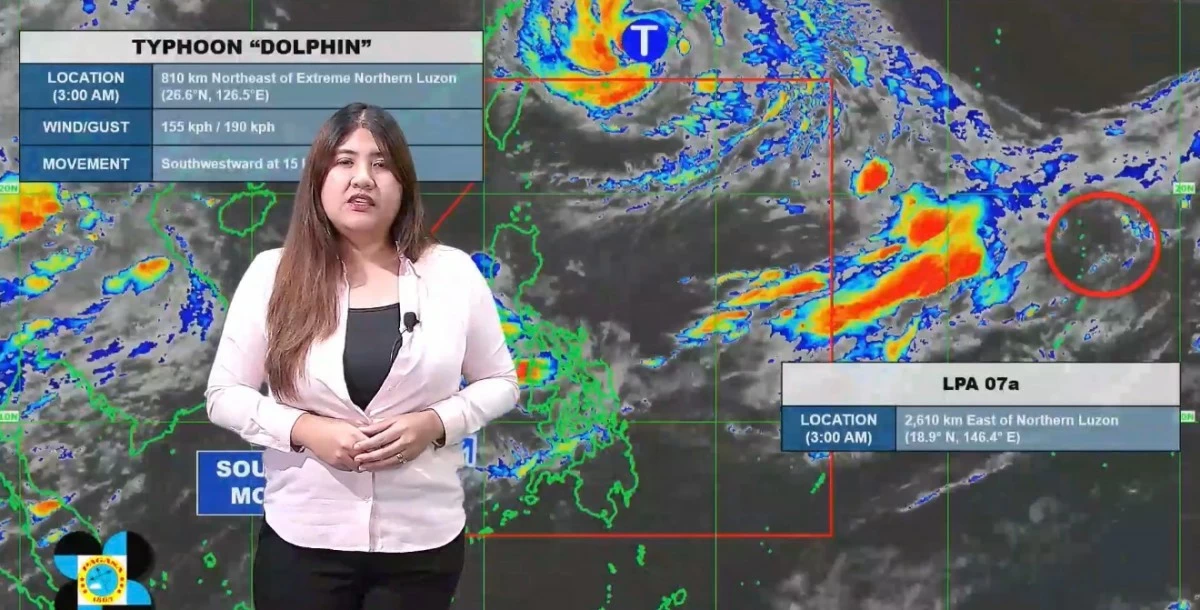
(DOST-PAGASA)
Typhoon Dolphin is enhancing the southwest monsoon or “habagat,” which is bringing heavy rains particularly over the western section of Luzon and rainy conditions over other parts of the country, the Philippine Atmospheric, Geophysical and Astronomical Services Administration (PAGASA) said on Saturday, Aug. 8.
PAGASA weather specialist Veronica Torres said Dolphin remains unlikely to enter the Philippine Area of Responsibility (PAR) or directly affect any part of the country.
“Ito namang bagyong [Dolphin] ito ay mababa ‘yung tiyansang pumasok ng ating Philippine Area of Responsibility at magkaroon ng direktang epekto sa kahit anong parte ng ating bansa (This typhoon, Dolphin, has a low chance of entering the Philippine Area of Responsibility and directly affecting any part of the country),” she said.
“Gayunpaman, nahahatak nga nito ‘yung southwest monsoon o habagat na nakakaapekto sa may Luzon at Visayas (However, it is enhancing the southwest monsoon or habagat, which is affecting Luzon and the Visayas),” she added.
According to Torres, the enhancement of the habagat is causing heavy rains, especially over western Luzon, while much of Luzon, the Visayas, and parts of Mindanao are experiencing rainy conditions.
“At dahil nga nahahatak nito ‘yung habagat, nagkakaroon nga tayo ng mga malalakas na pag-ulan lalo na sa western section ng Luzon at nagiging maulan nga ‘yung malaking bahagi ng Luzon, Visayas, and some parts of Mindanao (And because it is enhancing the habagat, we are experiencing heavy rains, especially over the western section of Luzon, while a large portion of Luzon, the Visayas, and some parts of Mindanao are experiencing rainy conditions),” she said.
As of 3 a.m., PAGASA said Dolphin was located 810 kilometers northeast of extreme Northern Luzon.
It noted that the typhoon was packing maximum sustained winds of 155 kilometers per hour (kph) and gustiness of up to 190 kph while moving southwest at 15 kph.
Meanwhile, the state weather bureau said it is also monitoring a low-pressure area (LPA) outside PAR that has a high chance of developing into a tropical cyclone within the next 24 hours.
“Ganoon pa man, mababa naman ‘yung tiyansang magkaroon ito ng direktang epekto sa ating bansa, at mababa rin ‘yung tiyansang pumasok ng ating Philippine Area of Responsibility (Nevertheless, it has a low chance of directly affecting our country, and it also has a low chance of entering the Philippine Area of Responsibility),” she added.
Torres advised the public to continue monitoring PAGASA updates.