







PAGASA warns heavy rains may persist through weekend
Published Aug 5, 2026 01:51 pm


At A Glance
- PAGASA weather specialist Benison Estareja said the typhoon internationally named "Dolphin," which remains outside the Philippine Area of Responsibility (PAR), will gradually strengthen the southwest monsoon or "habagat" as Tropical Storm Maymay weakens after its expected landfall over Northern Luzon.
PAGASA
Tropical Storm Maymay (international name “Kujira”) is expected to bring heavy rains over parts of Luzon before the enhanced southwest monsoon or “habagat” keeps wet weather in many areas through the weekend, the Philippine Atmospheric, Geophysical and Astronomical Services Administration (PAGASA) said on Wednesday, Aug. 5.
During a press conference, PAGASA weather specialist Benison Estareja said the typhoon internationally named “Dolphin,” which remains outside the Philippine Area of Responsibility (PAR), will gradually strengthen the habagat as Maymay weakens after its expected landfall over Northern Luzon.
“Unti-unti nitong palalakasin yung southwest monsoon o ‘hanging habagat’ sa malaking bahagi ng ating bansa lalo na po the moment na humina at malusaw itong si Bagyong Maymay sa susunod po na 24 to 48 hours (Typhoon Dolphin will gradually strengthen the southwest monsoon over a large part of the country, especially once Tropical Storm Maymay weakens and dissipates within the next 24 to 48 hours),” Estareja said.
‘Maymay’ nears landfall
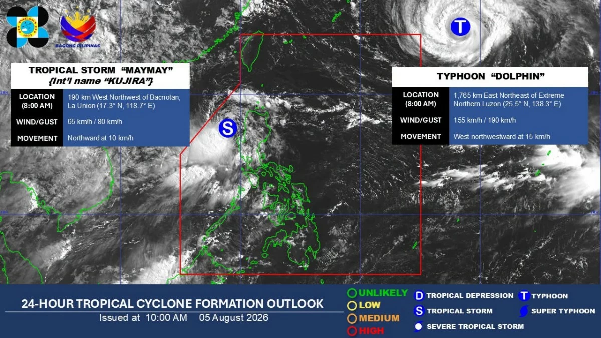
As of 10 a.m., the center of Tropical Storm Maymay was located 185 kilometers west northwest of Bacnotan, La Union.
It had maximum sustained winds of 65 kilometers per hour (kph), gusts of up to 80 kph, and was moving northward at 10 kph.
Estareja said Maymay is forecast to generally move eastward over the next 36 hours and may make landfall between La Union and Ilocos Sur on Wednesday evening while still a tropical storm.
After interacting with land, Maymay is expected to weaken into a tropical depression as it crosses portions of Ilocos Region and Cordillera Administrative Region.
It may further weaken into a low-pressure area over Cagayan Valley by Thursday afternoon, Aug. 6.
Meanwhile, Typhoon Dolphin was located 1,765 kilometers east northeast of extreme Northern Luzon as of 10 a.m.
It had maximum sustained winds of 155 kph, gusts of up to 190 kph, and was moving west northwestward at 15 kph.
Wind signals remain in effect
Based on PAGASA’s Tropical Cyclone Bulletin No. 5, Wind Signal No. 2 remained hoisted over Ilocos Sur, northern and central portions of La Union (Luna, Caba, Santol, Bauang, City of San Fernando, San Juan, Bagulin, Aringay, Bangar, San Gabriel, Burgos, Naguilian, Bacnotan, Sudipen, Balaoan), northwestern portion of Pangasinan (Anda, Bolinao, Bani), southwestern portion of Abra (Manabo, Pidigan, Langiden, Luba, Boliney, Sallapadan, Bucloc, Tubo, Villaviciosa, Pilar, Peñarrubia, San Isidro, San Quintin, Bangued, Bucay, Danglas, La Paz, Tayum), western portion of Mountain Province (Besao, Tadian, Bauko, Sagada, Sabangan), and northwestern portion of Benguet (Mankayan, Kapangan, Kibungan, Sablan, Bakun).
Signal No. 1 remained in effect over Ilocos Norte, the rest of La Union, the rest of Pangasinan, Apayao, the rest of Abra, Kalinga, the rest of Mountain Province, Ifugao, the rest of Benguet, Cagayan, Isabela, Quirino, Nueva Vizcaya, northern portion of Zambales (Candelaria, Santa Cruz, Masinloc, Palauig), northern portion of Tarlac (Mayantoc, San Clemente, Camiling, Santa Ignacia, Gerona, Paniqui, Moncada, San Manuel, Anao, Ramos, Pura), northern portion of Nueva Ecija (Carranglan, Lupao, Cuyapo, Talugtug, Nampicuan, Guimba, Science City of Muñoz, San Jose City, Pantabangan), and northern and central portions of Aurora (Dilasag, Casiguran, Dinalungan, Dipaculao).
Heavy rains, flood risks
Estareja said the next 24 hours will be critical as the combined effects of Maymay and the enhanced southwest monsoon are expected to bring widespread rains over most of Luzon.
“Within the next 24 hours, crucial part po ito because we're seeing na yung epekto nitong si Bagyong Maymay plus the southwest monsoon mararamdaman po sa malaking bahagi ng Luzon, lalo na sa western section (The next 24 hours are crucial because we expect the combined effects of Tropical Storm Maymay and the southwest monsoon to be felt across much of Luzon, particularly the western section),” he said.
From Wednesday to Thursday noon, PAGASA said La Union and Benguet may receive more than 200 millimeters of rainfall, or intense to torrential rains.
Ilocos Sur, Pangasinan, Abra, and Zambales may receive 100 to 200 millimeters of rainfall, or heavy to intense rains.
Meanwhile, Ilocos Norte, Apayao, Kalinga, Mountain Province, Ifugao, Nueva Vizcaya, Tarlac, Nueva Ecija, Bataan, Pampanga, and Bulacan may experience 50 to 100 millimeters of rainfall, or moderate to heavy rains.
From Thursday noon to Friday noon, Aug. 7, Ilocos Sur, La Union, Pangasinan, and Benguet may still receive 50 to 100 millimeters of rainfall due to Maymay.
The habagat is also expected to bring moderate to heavy rainfall over Metro Manila, Rizal, Cavite, Batangas, and Occidental Mindoro from Wednesday to Thursday noon.
From Thursday noon to Friday noon, Occidental Mindoro may receive 100 to 200 millimeters of rainfall, while Zambales, Bataan, Cavite, Batangas, and Antique may experience 50 to 100 millimeters.
Estareja said rains may persist through the weekend and even into early next week as Typhoon Dolphin continues to enhance the southwest monsoon.
“Make sure po na coordinated tayo sa ating mga local government units kung kinakailangan po ng rescue or evacuation. And we're talking of antecedent rainfall, ilang araw na po magkakaroon ng mga pag-ulan. So the moment na mayroon tayong pag-ulan, pagsapit po ng weekend, mas tumataas ang banta ng mga flash floods at landslides (Make sure we are coordinated with our local government units if rescue or evacuation becomes necessary. We are talking about antecedent rainfall, with several days of rain expected. By the weekend, the threat of flash floods and landslides will become even higher),” he said.