

ADVERTISEMENT

LPA west of La Union may develop into a tropical cyclone within 24 hours — PAGASA

Published Aug 4, 2026 06:24 pm

At A Glance

  • The LPA, designated as LPA 08a, was located 180 kilometers west of Bacnotan, La Union, or over the West Philippine Sea, as of 3 p.m.
  • Its chance of development was earlier assessed as low but increased to high Tuesday afternoon.
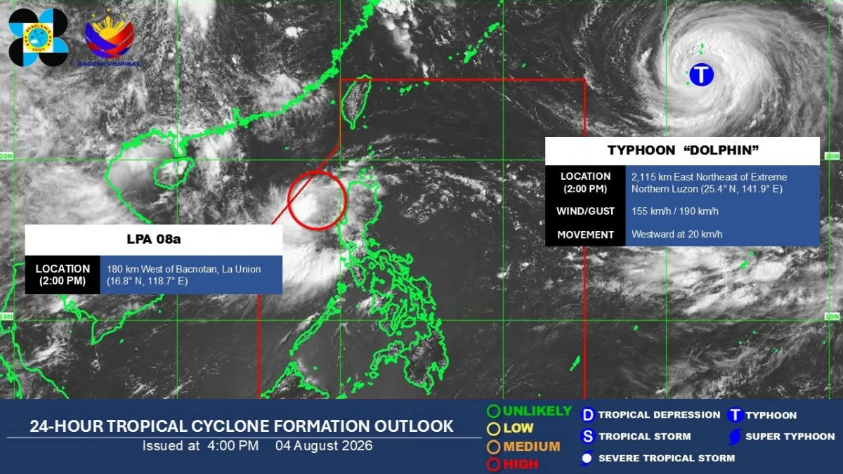
PAGASA
PAGASA
The low-pressure area (LPA) off the coast of La Union now has a “high chance” of developing into a tropical depression within the next 24 hours, the Philippine Atmospheric, Geophysical and Astronomical Services Administration (PAGASA) said Tuesday, Aug. 4.
The LPA, designated as LPA 08a, was located 180 kilometers west of Bacnotan, La Union, or over the West Philippine Sea, as of 3 p.m.
Its chance of development was earlier assessed as low but increased to high Tuesday afternoon.
“Kung saka-sakali po ay by tomorrow (August 5), bagyo na ito, papangalanan natin na bagyong ‘Maymay’ (If it becomes a tropical cyclone by tomorrow, we will name it ‘Maymay’),” PAGASA weather specialist Benison Estareja said.
The other LPA that was formerly Tropical Depression Luis dissipated as of 2 p.m. Tuesday.
“Mataas yung tsansa niya [LPA 08a] na kapag isang bagyo na po ito ay kikilos ito ng mabagal, pa-silangan, or moving back towards dito sa may Ilocos region. Maaaring magkaroon muli ng interaksyon sa kalupaan (There is a high chance that once LPA 08a becomes a tropical cyclone, it will move slowly eastward, or back toward the Ilocos region. It may once again interact with land),” Estareja said.
He added that the weather disturbance may again weaken into an LPA as it interacts with land, afterward its cloud clusters may gradually merge with the circulation of the typhoon outside the Philippine Area of Responsibility (PAR), with the international name “Dolphin.”
Typhoon-enhanced ‘habagat’
As of 3 p.m. Tuesday, Typhoon Dolphin was located 2,095 kilometers east-northeast of extreme Northern Luzon.
It was moving westward at 20 kilometers per hour (kph), with maximum sustained winds of 155 kph near the center and gustiness of up to 190 kph.
“Kung mapapanatili po yung kanyang pagkilos na pa-kanluran, maliit yung tsansa na siya ay papasok pa ng ating area of responsibility. Pero hindi pa rin natin ito niru-rule out dahil sa mga tsansa po na posibeng sumubsub pa ito depende po sa lakas ng high-pressure area doon sa may North Pacific Ocean (If it maintains its westward movement, there is a small chance that it will enter our area of responsibility. But we are not ruling it out because it could still dip farther south depending on the strength of the high-pressure area over the North Pacific Ocean),” Estareja explained.
“Nonetheless, kung ito man po ay papasok o hindi ng ating PAR ay makikita natin na magkakaroon ng enhancement o pag-iibayo po ng southwest monsoon simula po yan sa Thursday (August 6) dito sa malaking bahagi po ng Luzon and western Visayas” (Nonetheless, whether or not it enters our PAR, we will see an enhancement or strengthening of the southwest monsoon starting Thursday over a large part of Luzon and the western Visayas),” he added.
Heavy rainfall outlook
Due to the potential tropical depression, PAGASA said 100 to 200 millimeters of rain (heavy to intense) may prevail from from Tuesday to Wednesday afternoon over La Union, Pangasinan, Benguet, and Zambales.
Rainfall of 50 to 100 millimeters (moderate to heavy) is expected over Ilocos Sur, Ifugao, Mountain Province, Tarlac, Nueva Ecija, Bataan, Pampanga, and Bulacan during the same period.
From Wednesday afternoon to Thursday afternoon, 100 to 200 millimeters of rainfall may be experienced in Ilocos Sur, La Union, and Benguet, while 50 to 100 millimeters is forecast over Pangasinan, Abra, Ifugao, Mountain Province, and Nueva Vizcaya.
Due to the enhanced habagat, 50 to 100 millimeters of rain is also expected from Tuesday to Wednesday afternoon over Metro Manila, Rizal, Cavite, Batangas, and Occidental Mindoro.
From Wednesday afternoon to Thursday afternoon, 100 to 200 millimeters of rain is forecast over Occidental Mindoro, while 50 to 100 millimeters may prevail over Zambales, Bataan, Tarlac, Nueva Ecija, Pampanga, Cavite, Batangas, and Antique.
From Thursday afternoon to Friday afternoon, Aug. 7, 50 to 100 millimeters of rain is forecast over Ilocos Sur, La Union, Pangasinan, Benguet, Zambales, Bataan, Occidental Mindoro, and Antique.
Estareja warned of a high chance of flooding, overflowing rivers, and landslides due to the expected heavy rains.

Related Tags

PAGASA LOW PRESSURE AREA (LPA) TROPICAL DEPRESSION MAYMAY HABAGAT TYPHOON DOLPHIN
ADVERTISEMENT
.most-popular .layout-ratio{ padding-bottom: 79.13%; } @media (min-width: 768px) and (max-width: 1024px) { .widget-title { font-size: 15px !important; } }

{{ articles_filter_1561_widget.title }}

.most-popular .layout-ratio{ padding-bottom: 79.13%; } @media (min-width: 768px) and (max-width: 1024px) { .widget-title { font-size: 15px !important; } }

{{ static_articles_1562_widget.title }}

.most-popular .layout-ratio{ padding-bottom: 79.13%; } @media (min-width: 768px) and (max-width: 1024px) { .widget-title { font-size: 15px !important; } }

{{ articles_filter_1563_widget.title }}

{{ articles_filter_1564_widget.title }}

.mb-article-details { position: relative; } .mb-article-details .article-body-preview, .mb-article-details .article-body-summary{ font-size: 17px; line-height: 30px; font-family: "Libre Caslon Text", serif; color: #000; } .mb-article-details .article-body-preview iframe , .mb-article-details .article-body-summary iframe{ width: 100%; margin: auto; } .read-more-background { background: linear-gradient(180deg, color(display-p3 1.000 1.000 1.000 / 0) 13.75%, color(display-p3 1.000 1.000 1.000 / 0.8) 30.79%, color(display-p3 1.000 1.000 1.000) 72.5%); position: absolute; height: 200px; width: 100%; bottom: 0; display: flex; justify-content: center; align-items: center; padding: 0; } .read-more-background a{ color: #000; } .read-more-btn { padding: 17px 45px; font-family: Inter; font-weight: 700; font-size: 18px; line-height: 16px; text-align: center; vertical-align: middle; border: 1px solid black; background-color: white; } .hidden { display: none; }
function initializeAllSwipers() { // Get all hidden inputs with cms_article_id document.querySelectorAll('[id^="cms_article_id_"]').forEach(function (input) { const cmsArticleId = input.value; const articleSelector = '#article-' + cmsArticleId + ' .body_images'; const swiperElement = document.querySelector(articleSelector); if (swiperElement && !swiperElement.classList.contains('swiper-initialized')) { new Swiper(articleSelector, { loop: true, pagination: false, navigation: { nextEl: '#article-' + cmsArticleId + ' .swiper-button-next', prevEl: '#article-' + cmsArticleId + ' .swiper-button-prev', }, }); } }); } setTimeout(initializeAllSwipers, 3000); const intersectionObserver = new IntersectionObserver( (entries) => { entries.forEach((entry) => { if (entry.isIntersecting) { const newUrl = entry.target.getAttribute("data-url"); if (newUrl) { history.pushState(null, null, newUrl); let article = entry.target; // Extract metadata const author = article.querySelector('.author-section').textContent.replace('By', '').trim(); const section = article.querySelector('.section-info ').textContent.replace(' ', ' '); const title = article.querySelector('.article-title h1').textContent; // Parse URL for Chartbeat path format const parsedUrl = new URL(newUrl, window.location.origin); const cleanUrl = parsedUrl.host + parsedUrl.pathname; // Update Chartbeat configuration if (typeof window._sf_async_config !== 'undefined') { window._sf_async_config.path = cleanUrl; window._sf_async_config.sections = section; window._sf_async_config.authors = author; } // Track virtual page view with Chartbeat if (typeof pSUPERFLY !== 'undefined' && typeof pSUPERFLY.virtualPage === 'function') { try { pSUPERFLY.virtualPage({ path: cleanUrl, title: title, sections: section, authors: author }); } catch (error) { console.error('ping error', error); } } // Optional: Update document title if (title && title !== document.title) { document.title = title; } } } }); }, { threshold: 0.1 } ); function showArticleBody(button) { const article = button.closest("article"); const summary = article.querySelector(".article-body-summary"); const body = article.querySelector(".article-body-preview"); const readMoreSection = article.querySelector(".read-more-background"); // Hide summary and read-more section summary.style.display = "none"; readMoreSection.style.display = "none"; // Show the full article body body.classList.remove("hidden"); } document.addEventListener("DOMContentLoaded", () => { let loadCount = 0; // Track how many times articles are loaded const offset = [1, 2, 3, 4, 5, 6, 7, 8, 9, 10]; // Offset values const currentUrl = window.location.pathname.substring(1); let isLoading = false; // Prevent multiple calls if (!currentUrl) { console.log("Current URL is invalid."); return; } const sentinel = document.getElementById("load-more-sentinel"); if (!sentinel) { console.log("Sentinel element not found."); return; } function isSentinelVisible() { const rect = sentinel.getBoundingClientRect(); return ( rect.top < window.innerHeight && rect.bottom >= 0 ); } function onScroll() { if (isLoading) return; if (isSentinelVisible()) { if (loadCount >= offset.length) { console.log("Maximum load attempts reached."); window.removeEventListener("scroll", onScroll); return; } isLoading = true; const currentOffset = offset[loadCount]; window.loadMoreItems().then(() => { let article = document.querySelector('#widget_1690 > div:nth-last-of-type(2) article'); intersectionObserver.observe(article) loadCount++; }).catch(error => { console.error("Error loading more items:", error); }).finally(() => { isLoading = false; }); } } window.addEventListener("scroll", onScroll); });

Sign up by email to receive news.