






Manila Bulletin
 Philippines
National
'Luis' weakens into LPA; another LPA forms off the coast of La Union
Philippines
National
'Luis' weakens into LPA; another LPA forms off the coast of La Union
Philippines
National
'Luis' weakens into LPA; another LPA forms off the coast of La Union
'Luis' weakens into LPA; another LPA forms off the coast of La Union
Published Aug 3, 2026 11:10 pm


At A Glance
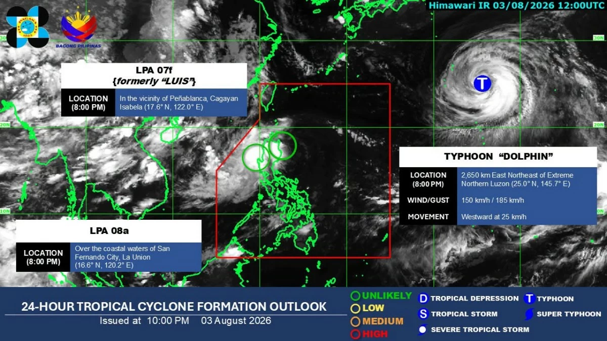
- PAGASA said the remnant low of Luis may still move generally east-northeastward toward the Philippine Sea before being fully assimilated into the circulation of a typhoon, internationally called "Dolphin," which was outside the Philippine Area of Responsibility (PAR).
- Meanwhile, a new LPA, designated as LPA 08a, formed over the coastal waters of San Fernando City, La Union.
PAGASA
Tropical Depression Luis weakened into a low-pressure area (LPA) Monday evening, Aug. 3, while another LPA formed over the coastal waters of La Union, said the Philippine Atmospheric, Geophysical and Astronomical Services Administration (PAGASA).
In its 11 p.m. tropical cyclone bulletin, PAGASA said Luis weakened into an LPA at 8 p.m. while in the vicinity of Peñablanca, Cagayan, due to unfavorable conditions.
All tropical cyclone wind signals raised over areas affected by Luis were subsequently lifted.
PAGASA said the remnant low of Luis may still move generally east-northeastward toward the Philippine Sea before being fully assimilated into the circulation of a typhoon, internationally called “Dolphin,” which was outside the Philippine Area of Responsibility (PAR).
Heavy rains to continue
Meanwhile, a new LPA, designated as LPA 08a, formed over the coastal waters of San Fernando City, La Union.
Despite the weakening of Luis, heavy rainfall is expected over parts of Luzon due to the new LPA and the southwest monsoon, or “habagat.”
From Monday evening to Tuesday evening, Aug. 4, 100 to 200 millimeters of rain (heavy to intense) is forecast over La Union, Pangasinan, Benguet, Tarlac, Zambales, and Bataan.
Rainfall of 50 to 100 millimeters (moderate to heavy) is expected over Metro Manila, Ilocos Sur, Ifugao, Mountain Province, Nueva Vizcaya, Nueva Ecija, Aurora, Bulacan, Pampanga, Cavite, and Batangas.
From Tuesday evening to Wednesday evening, Aug. 5, 100 to 200 millimeters of rain is forecast over La Union, Pangasinan, and Benguet, while 50 to 100 millimeters is expected over Ilocos Sur and Nueva Vizcaya.
The habagat is also expected to bring heavy to intense rainfall over Zambales, Bataan, Tarlac, and Occidental Mindoro from Tuesday evening to Wednesday evening.
Fifty to 100 millimeters of rain is also forecast over Metro Manila, Aurora, Nueva Ecija, Bulacan, Pampanga, Cavite, Batangas, Laguna, Rizal, and Antique during the same period.
From Wednesday evening to Thursday evening, Aug. 6, moderate to heavy rainfall may persist in La Union, Pangasinan, Benguet, Zambales, Bataan, Cavite, Batangas, Occidental Mindoro, and Antique.
‘Dolphin’ may enhance ‘habagat’
As of 8 p.m. Monday, Typhoon Dolphin was located 2,650 kilometers east-northeast of extreme Northern Luzon.
It had maximum sustained winds of 150 kilometers per hour near the center and gustiness of up to 185 kph. It was moving westward at 25 kph.
PAGASA earlier said it was not ruling out the possibility that Dolphin could enter the northeastern periphery of the PAR, although it was less likely to make landfall.
The typhoon may also enhance the southwest monsoon in the coming days.