






Manila Bulletin
 Philippines
National
After 'Luis,' Typhoon Dolphin to enhance 'habagat', bring more rain — PAGASA
Philippines
National
After 'Luis,' Typhoon Dolphin to enhance 'habagat', bring more rain — PAGASA
Philippines
National
After 'Luis,' Typhoon Dolphin to enhance 'habagat', bring more rain — PAGASA
After 'Luis,' Typhoon Dolphin to enhance 'habagat', bring more rain — PAGASA
Published Aug 3, 2026 01:13 pm


At A Glance
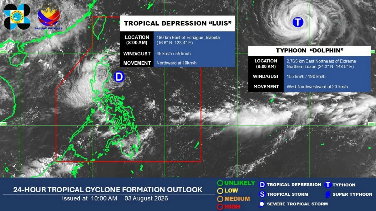
- Tropical Depression Luis was last located 180 kilometers east of Echague, Isabela, as of Monday, packing maximum sustained winds of 45 kilometers per hour (kph) and gustiness of up to 55 kph. It was moving northward at 15 kph.
- It may weaken into a low-pressure area (LPA) or become part of Typhoon Dolphin's trough and circulation by midweek.
- While Luis is expected to weaken, Dolphin may bring more rain as it enhances the habagat.
PAGASA
Tropical Depression Luis is expected to bring heavy rains over parts of Luzon before weakening, but the country may continue to see significant rainfall as a typhoon internationally called “Dolphin” enhances the southwest monsoon or “habagat,” the Philippine Atmospheric, Geophysical and Astronomical Services Administration (PAGASA) said on Monday, Aug. 3.
In a press conference, PAGASA weather specialist Charmagne Varilla said the heaviest rains on Monday were expected over Pangasinan, where more than 200 millimeters of rainfall (intense to torrential) may be recorded.
La Union, Zambales, Tarlac, and Bataan may receive 100 to 200 millimeters of rain (heavy to intense), while southern Cagayan, Cordillera Administrative Region, Ilocos Region, Central Luzon, Metro Manila, Cavite, and Batangas may experience 50 to 100 millimeters of rainfall (moderate to heavy).
“Posible ang mga localized flooding and landslide, lalong-lalo na nga sa mga areas na may very high to high susceptibility (Localized flooding and landslides are possible, especially in areas with very high to high susceptibility),” Varilla warned.
Luis was last located 180 kilometers east of Echague, Isabela, as of Monday, packing maximum sustained winds of 45 kilometers per hour (kph) and gustiness of up to 55 kph. It was moving northward at 15 kph.
Varilla said the tropical depression may turn northwestward in the next few hours and could make landfall over the Cagayan-Isabela area between Monday evening and early Tuesday morning, Aug. 4.
After making its closest approach or landfall, Luis is expected to recurve northeastward on Tuesday due to its interaction with Typhoon Dolphin, which remains outside the Philippine Area of Responsibility (PAR).
By Wednesday, Varilla said Luis may weaken into a low-pressure area (LPA) or become part of Dolphin's trough and circulation.
Wind Signal No. 1 still in effect
As of 11 a.m. Monday, Tropical Cyclone Wind Signal No. 1 remains hoisted over the central and eastern portions of Cagayan, Isabela, and Quirino; eastern and southern portions of Apayao; eastern portion of Kalinga; eastern portion of Mountain Province; eastern portion of Ifugao; and northern portion of Aurora.
Varilla said the areas under the wind signal were expected to experience minimal impacts, including slight disruptions to daily activities and minimal effects on homes, transportation, agriculture, safety, and telecommunications.
The wind signal is expected to remain in effect until Tuesday, with Luis forecast to weaken into an LPA by Wednesday.
Typhoon-enhanced ‘habagat’
While Luis is expected to weaken, Dolphin may bring more rain as it enhances the habagat.
Varilla said PAGASA has high confidence in the enhancement of the southwest monsoon, with the western section of Luzon expected to be the most affected.
“Not only within this week, posible po na magtuloy-tuloy yung habagat po natin hanggang sa succeeding week pa po (Not only within this week, it is possible that the southwest monsoon may continue into the succeeding week),” Varilla said.
The habagat is expected to bring significant rains to more areas as Luis moves away.
From Tuesday noon to Wednesday noon, significant rainfall may persist over most of Central Luzon and the western section of Northern Luzon, including La Union, Pangasinan, Zambales, Tarlac, and Bataan.
Occidental Mindoro may also receive significant rains due to the habagat.
By Wednesday noon to Thursday noon, Aug. 6, the habagat is expected to affect the entire country, with significant rains still possible over Zambales, Bataan, Cavite, Batangas, Occidental Mindoro, and Antique.
“Muli, mas i-emphasize po natin yung magiging epekto ng malalakas na mga pag-ulan na dadalhin ng habagat at nung si Bagyong Luis (Again, we want to emphasize the effects of the heavy rains that will be brought by the southwest monsoon and Typhoon Luis),” Varilla said.
‘Dolphin’ unlikely to make landfall
Typhoon Dolphin was last located 2,735 kilometers east-northeast of extreme Northern Luzon, packing maximum sustained winds of 155 kph and gustiness of up to 190 kph.
It may enter the PAR in the coming days but has a low chance of making landfall in the country, Varilla said.
“Kung papasok man, more on dito lang sa may northern periphery ng ating PAR. Ngunit, wala itong direktang epekto sa alinmang bahagi ng ating bansa (If it enters, it will likely remain over the northern periphery of our PAR. However, it will have no direct impact on any part of our country),” she said.