






Manila Bulletin
 Philippines
National
'Luis' may strengthen into tropical storm; super typhoon outside PAR may enhance 'habagat'
Philippines
National
'Luis' may strengthen into tropical storm; super typhoon outside PAR may enhance 'habagat'
Philippines
National
'Luis' may strengthen into tropical storm; super typhoon outside PAR may enhance 'habagat'
'Luis' may strengthen into tropical storm; super typhoon outside PAR may enhance 'habagat'
Published Aug 2, 2026 08:57 am
|
Updated Aug 2, 2026 03:40 pm


At A Glance
- Signal No. 1 was raised over Polillo Islands, Camarines Norte, northern Camarines Sur, and Catanduanes due to Tropical Depression Luis.
- PAGASA was also monitoring a super typhoon, internationally called "Dolphin," outside the Philippine Area of Responsibility (PAR).
PAGASA
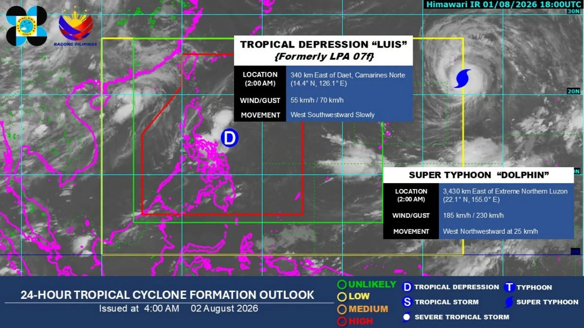
Tropical Depression Luis may intensify into a tropical storm by Monday, Aug. 3, potentially prompting the raising of Tropical Cyclone Wind Signal No. 2 in some areas in Luzon, the Philippine Atmospheric, Geophysical and Astronomical Services Administration (PAGASA) said on Sunday, Aug. 2.
PAGASA weather specialist Obet Badrina said Luis slightly intensified while moving slowly west-southwestward, with maximum sustained winds of 55 kilometers per hour (kph) near the center and gustiness of up to 70 kph.
As of 5 a.m., Luis was located 295 kilometers east of Daet, Camarines Norte.
Signal No. 1 was raised over Polillo Islands, Camarines Norte, northern Camarines Sur, and Catanduanes.
Badrina said Luis was already bringing cloudy skies over most of Luzon and the Visayas.
Mindanao may have fair weather although isolated rain showers and thunderstorms remained possible.
Moderate to heavy rains were expected over Isabela, Quirino, Aurora, Quezon, Camarines Norte, Camarines Sur, and Catanduanes over the next 24 hours.
Scattered rains and thunderstorms may also affect Metro Manila, Cagayan Valley, Cavite, Laguna, Batangas, Rizal, Albay, Sorsogon, Masbate, Aurora, Nueva Ecija, Bulacan, Occidental Mindoro, Oriental Mindoro, Marinduque, Romblon, Aklan, and Antique.
Luis is expected to continue affecting the country over the next few days, particularly the eastern sections of Central Luzon and the Bicol Region, where rains and gusty winds may persist, Badrina said.
Super Typhoon Dolphin
Badrina said PAGASA was also monitoring a super typhoon, internationally called “Dolphin,” outside the Philippine Area of Responsibility (PAR).
Dolphin was located 3,410 kilometers east of extreme Northern Luzon, packing maximum sustained winds of 185 kph near the center and gustiness of up to 230 kph.
It was moving west-northwestward at 25 kph.
There is a possibility that it may pass through the northern boundary of PAR, but for now, the chances remain small, Badrina said.
Dolphin may enhance the southwest monsoon or “habagat,” and bring moderate to heavy rains over Pangasinan, Zambales, and Bataan over the next 24 hours.
By Tuesday, moderate to heavy rains due to the habagat may continue over Pangasinan, Zambales, Bataan, and Occidental Mindoro.
Badrina said most of Central Luzon, Southern Luzon, parts of Bicol Region, and Metro Manila may also experience scattered rains due to the enhanced southwest monsoon.
He noted that Dolphin may eventually absorb Luis as the super typhoon approaches the northern boundary of PAR.
Luis may weaken into a low-pressure area by Wednesday, Aug. 5, Badrina added.
He advised the public to remain cautious as the rains may trigger flash floods and landslides, particularly in vulnerable and low-lying areas.