






Manila Bulletin
 Philippines
National
'Luis' less likely to make landfall; strong winds, rains still loom
Philippines
National
'Luis' less likely to make landfall; strong winds, rains still loom
Philippines
National
'Luis' less likely to make landfall; strong winds, rains still loom
'Luis' less likely to make landfall; strong winds, rains still loom
Typhoon outside PAR may also enhance 'habagat' by midweek
Published Aug 2, 2026 05:57 pm


At A Glance
- PAGASA weather specialist Grace Castañeda-Carpio said cloudy and rainy conditions may persist over most of Luzon, including Metro Manila, through Tuesday, Aug. 4, due to Tropical Depression Luis.
- Meanwhile, the typhoon internationally called "Dolphin" may only graze the northeastern boundary of the PAR, where it could enhance the southwest monsoon or "habagat" and bring rains over parts of the country by midweek.
- This means that as rains associated with Luis ease, habagat rains may take over in the coming days.
PAGASA
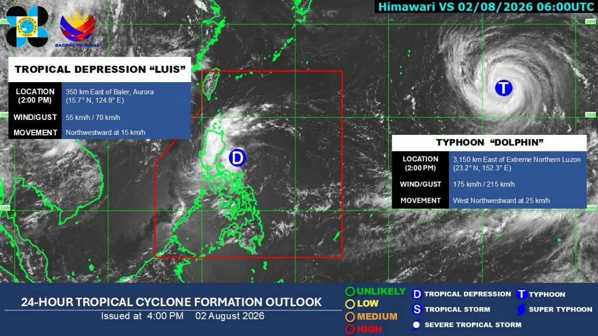
Tropical Depression Luis is unlikely to make landfall in the country, but the public should still brace for strong winds and rains as the weather disturbance may linger over the Philippine Sea while the southwest monsoon may strengthen by midweek, the Philippine Atmospheric, Geophysical and Astronomical Services Administration (PAGASA) said on Sunday afternoon, Aug. 2.
In its tropical cyclone bulletin issued at 5 p.m. Sunday, PAGASA said the center of Luis was estimated at 285 kilometers east of Baler, Aurora.
It was moving northwestward at 15 kilometers per hour (kph), with maximum sustained winds of 55 kph near the center and gustiness of up to 70 kph.
Tropical Cyclone Wind Signal No. 1 remained hoisted over Polillo Islands, Camarines Norte, northern Camarines Sur (Caramoan, Garchitorena, Lagonoy, Tinambac, and Siruma), and northern Catanduanes (Pandan, Caramoran, Bagamanoc, Panganiban, and Viga).
Moderate to heavy rains may also prevail over Quezon, Camarines Norte, Camarines Sur, and Catanduanes.
Meanwhile, scattered light to moderate rains, with occasional heavy precipitation, may persist over Metro Manila, Ilocos Region, Cordillera Administrative Region, Cagayan Valley, Central Luzon, Western Visayas, Cavite, Laguna, Batangas, Rizal, Albay, Sorsogon, Masbate, Occidental Mindoro, Oriental Mindoro, Marinduque, and Romblon.
PAGASA weather specialist Grace Castañeda-Carpio said cloudy and rainy conditions may persist over most of Luzon, including Metro Manila, through Tuesday, Aug. 4, due to the tropical depression.
Further intensification
PAGASA said the possibility of raising Signal No. 2 is not ruled out as Luis may intensify into a tropical storm within the next 24 hours while moving over the sea east of Central Luzon.
It added that the weather disturbance is expected to continue moving generally northwestward for the next 12 hours before turning east-northeastward for the remainder of the forecast period.
Based on the latest forecast track, the center of Luis will remain over the Philippine Sea.
However, a westward shift in the forecast track could still bring the cyclone closer to or result in landfall over Northern or Central Luzon.
Typhoon-enhanced ‘habagat’
Luis is expected to remain a tropical storm for only a short period before weakening as it turns east northeastward.
It may be downgraded into a remnant low by Wednesday, Aug. 5, before becoming fully assimilated into the circulation of a typhoon outside the Philippine Area of Responsibility (PAR) with the international name “Dolphin.”
Castañeda-Carpio said the typhoon was located 3,100 kilometers east of extreme Northern Luzon, packing maximum sustained winds of 175 kph near the center and gustiness of up to 215 kph.
It was moving west-northwestward at 25 kph.
However, she said PAGASA is not ruling out the possibility that Typhoon Dolphin may enter the PAR, although this remains less likely at the moment.
If Dolphin does enter the PAR, she said it may only graze the northeastern boundary, where it could enhance the southwest monsoon or “habagat” and bring rains over parts of the country in the next few days.
This means that as rains associated with Luis ease, habagat rains may take over in the coming days.
Castañeda-Carpio said the coming week is expected to be rainy in most parts of the country due to the combined effects of these weather systems.