






Manila Bulletin
 Philippines
National
'Kiyapo' exits PAR, Signal No. 1 stays as habagat brings heavy rains—PAGASA
Philippines
National
'Kiyapo' exits PAR, Signal No. 1 stays as habagat brings heavy rains—PAGASA
Philippines
National
'Kiyapo' exits PAR, Signal No. 1 stays as habagat brings heavy rains—PAGASA
'Kiyapo' exits PAR, Signal No. 1 stays as habagat brings heavy rains—PAGASA
By Jel Santos
Published Jul 25, 2026 12:36 pm
|
Updated Jul 25, 2026 02:35 pm


At A Glance
- PAGASA weather specialist Veronica Torres said Kiyapo left the country's area of responsibility at around 2 a.m. and now bears its international name, "Noul."
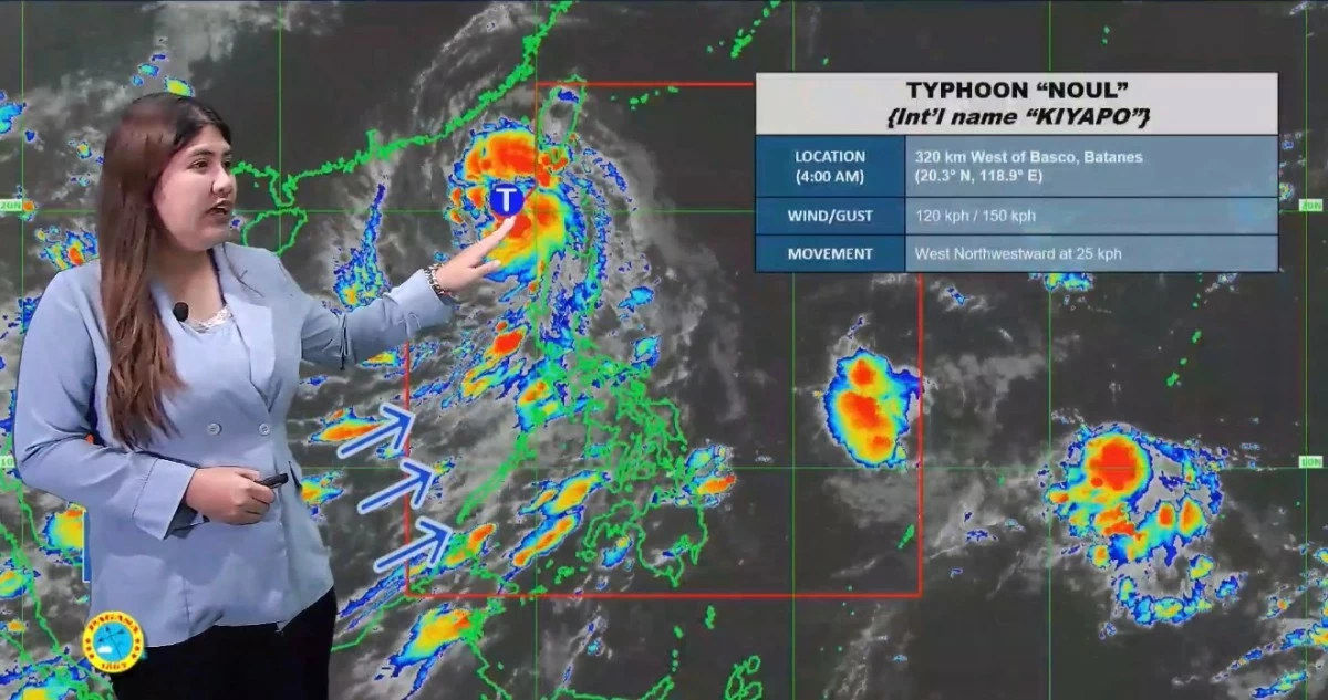
(PHOTO: DOST-PAGASA)
Typhoon Kiyapo has exited the Philippine Area of Responsibility (PAR), but storm signal number1 remains in effect over several areas as the cyclone and the enhanced southwest monsoon continue to bring strong winds and heavy rains, the Philippine Atmospheric, Geophysical and Astronomical Services Administration (PAGASA) said on Saturday, July 25.
PAGASA weather specialist Veronica Torres said Kiyapo left the country’s area of responsibility at around 2 a.m. and now bears its international name, “Noul.”
“Itong si Bagyong Kiyapo ay lumabas na ng ating Philippine Area of Responsibility (PAR) kaninang alas dos ng madaling araw. Ito ay may international name na ‘Noul’. Ngayon ay nasa Typhoon category na itong si Bagyong Kiyapo (Typhoon Kiyapo exited the Philippine Area of Responsibility (PAR) at around 2 a.m. today. It now carries the international name ‘Noul.’ It has intensified into the typhoon category),” Torres said.
As of 4 a.m., PAGASA said the typhoon was located 320 kilometers west of Basco, Batanes, with maximum sustained winds of 120 kilometers per hour (kph) near the center and gusts of up to 150 kph. It was moving west northwest at 25 kph.
The weather specialist said Kiyapo is forecast to continue moving northwestward before making landfall over southern mainland China.
“Inaasahan natin na tatahakin nito ang direksyong northwest bago mag-landfall sa may southern mainland China. Due to favorable conditions, posible itong lumakas pa in the next 12 hours, although papalayo naman ito sa ating bansa. Once na ito ay mag-landfall, inaasahan na ’yung tuluyan pa niyang paghina (It is expected to move northwestward before making landfall over southern mainland China. Due to favorable conditions, it may still intensify within the next 12 hours, although it is already moving away from the Philippines. Once it makes landfall, it is expected to weaken steadily),” she said.
Despite the cyclone’s exit from PAR, PAGASA maintained TCWS No. 1 over Batanes, the Babuyan Islands, the northwestern portion of mainland Cagayan, Ilocos Norte, and the northern portion of Apayao.
“Kahit nakalabas na sa ating PAR itong mino-monitor nating bagyo, meron parin tayong nakataas na Tropical Cyclone Wind Signal: Signal No. 1 sa may Batanes, Babuyan Islands, sa may northwestern portion ng mainland Cagayan, sa may Ilocos Norte, at sa northern portion din ng Apayao (Although the tropical cyclone we have been monitoring has already exited the Philippine Area of Responsibility, Tropical Cyclone Wind Signal No. 1 remains in effect over Batanes, the Babuyan Islands, the northwestern portion of mainland Cagayan, Ilocos Norte, and the northern portion of Apayao),” said Torres.
The state weather bureau said the combined effects of Kiyapo’s outer circulation and the enhanced southwest monsoon, locally known as habagat, will continue to bring strong winds across several parts of the country.
According to PAGASA, strong wind gusts will prevail on Saturday across most of Luzon, Western Visayas, the Negros Island Region, Northern Samar, Zamboanga del Norte, and Davao Oriental.
By Sunday, gusty conditions are forecast over Batanes, Cagayan, the Ilocos Region, Zambales, Bataan, Quezon, and the Mimaropa region, it added.