






Manila Bulletin
 Philippines
National
'Kiyapo' to bring heavy rains, strong winds as it nears extreme Northern Luzon
Philippines
National
'Kiyapo' to bring heavy rains, strong winds as it nears extreme Northern Luzon
Philippines
National
'Kiyapo' to bring heavy rains, strong winds as it nears extreme Northern Luzon
'Kiyapo' to bring heavy rains, strong winds as it nears extreme Northern Luzon
Published Jul 24, 2026 11:12 am


At A Glance
- PAGASA said the storm may pass close to northeastern Cagayan between Friday morning and afternoon before passing very close to or making landfall over the Babuyan Islands between Friday afternoon and evening.
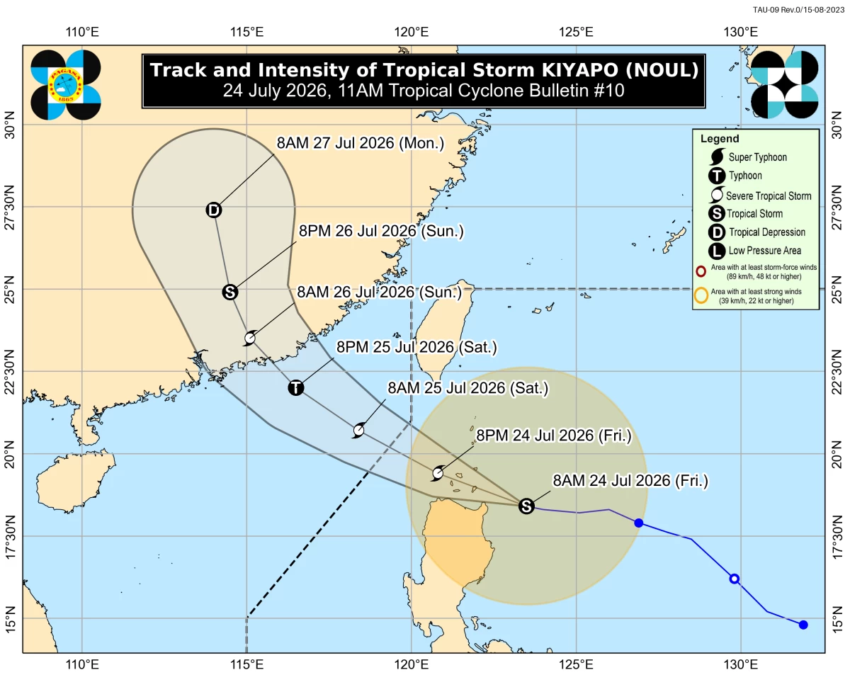
Tropical Storm Kiyapo’s forecast track and intensity (PAGASA)
Tropical Storm Kiyapo (international name “Noul”) is expected to pass close to northeastern Cagayan and may make landfall over the Babuyan Islands in the next few hours, the Philippine Atmospheric, Geophysical and Astronomical Services Administration (PAGASA) said on Friday, July 24.
As of 11 a.m., Kiyapo was located 135 kilometers east of Aparri, Cagayan, with maximum sustained winds of 75 kilometers per hour (kph) near the center and gustiness of up to 90 kph.
It was moving westward at 30 kph.
PAGASA said the storm may pass close to northeastern Cagayan between Friday morning and afternoon before passing very close to or making landfall over the Babuyan Islands between Friday afternoon and evening.
Kiyapo is forecast to exit the Philippine Area of Responsibility by Saturday morning, July 25.
Tropical Cyclone Wind Signal No. 2 is in effect over Batanes, the northern portion of Cagayan (Santa Ana, Gonzaga, Santa Teresita, Camalaniugan, Aparri, Ballesteros, Abulug, Pamplona, Sanchez-Mira, Claveria, Santa Praxedes, Buguey, Allacapan, Lal-Lo, Gattaran, Baggao, Lasam) including Babuyan Islands, the northern portion of Apayao (Luna, Santa Marcela, Calanasan, Pudtol, Flora), and the northern portion of Ilocos Norte (Pagudpud, Dumalneg, Adams, Bangui, Burgos, Vintar).
Signal No. 1 is in effect over the rest of mainland Cagayan, Isabela, Quirino, Nueva Vizcaya, the rest of Apayao, Abra, Kalinga, Mountain Province, Ifugao, Benguet, the rest of Ilocos Norte, Ilocos Sur, La Union, and the northern and central portions of Aurora (Dilasag, Casiguran, Dinalungan, Dipaculao).
PAGASA said minor to moderate impacts from gale-force winds are possible in areas under Signal No. 2, while minimal to minor impacts from strong winds may occur in areas under Signal No. 1.
The agency did not rule out raising Signal No. 3 if Kiyapo intensifies into a severe tropical storm while traversing the Batanes-Babuyan Islands area.
Heavy rainfall
Kiyapo is expected to bring 100 to 200 millimeters of rain (heavy to intense) to Batanes, Cagayan, Apayao, and Ilocos Norte from Friday until Saturday noon.
Rainfall of 50 to 100 millimeters (moderate to heavy) is also possible over Isabela, Kalinga, Abra, Benguet, Ilocos Sur, and La Union during the same period.
Meanwhile, the southwest monsoon or “habagat” is expected to bring 50 to 100 millimeters of rain to Occidental Mindoro, Palawan, Antique, Iloilo, Guimaras, and Negros Occidental from Friday until Saturday noon.
Bataan and Occidental Mindoro may also receive 50 to 100 millimeters of rain from Saturday noon until Sunday noon.
Cloudy skies with scattered rains due to Kiyapo may also affect Metro Manila, Pangasinan, Cavite, Laguna, Batangas, Rizal, Quezon, Bulacan, Pampanga, Bataan, Nueva Ecija, Tarlac, Zambales, Oriental Mindoro, and Romblon.
The rest of the country may also experience cloudy skies with scattered rains and thunderstorms due to the habagat.
PAGASA warned of possible flash floods and landslides, especially in areas vulnerable to these hazards.