

ADVERTISEMENT

PAGASA raises Signal No. 1 in 12 Luzon areas due to 'Kiyapo'

Raising of Signal No. 3 not ruled out

Published Jul 23, 2026 06:35 am

At A Glance

  • PAGASA said the highest wind signal that may be raised during Kiyapo's passage is Signal No. 2.
  • However, it did not rule out the possibility of raising Signal No. 3 if Kiyapo intensifies into a severe tropical storm while traversing the Batanes-Babuyan Islands area.
PAGASA
PAGASA
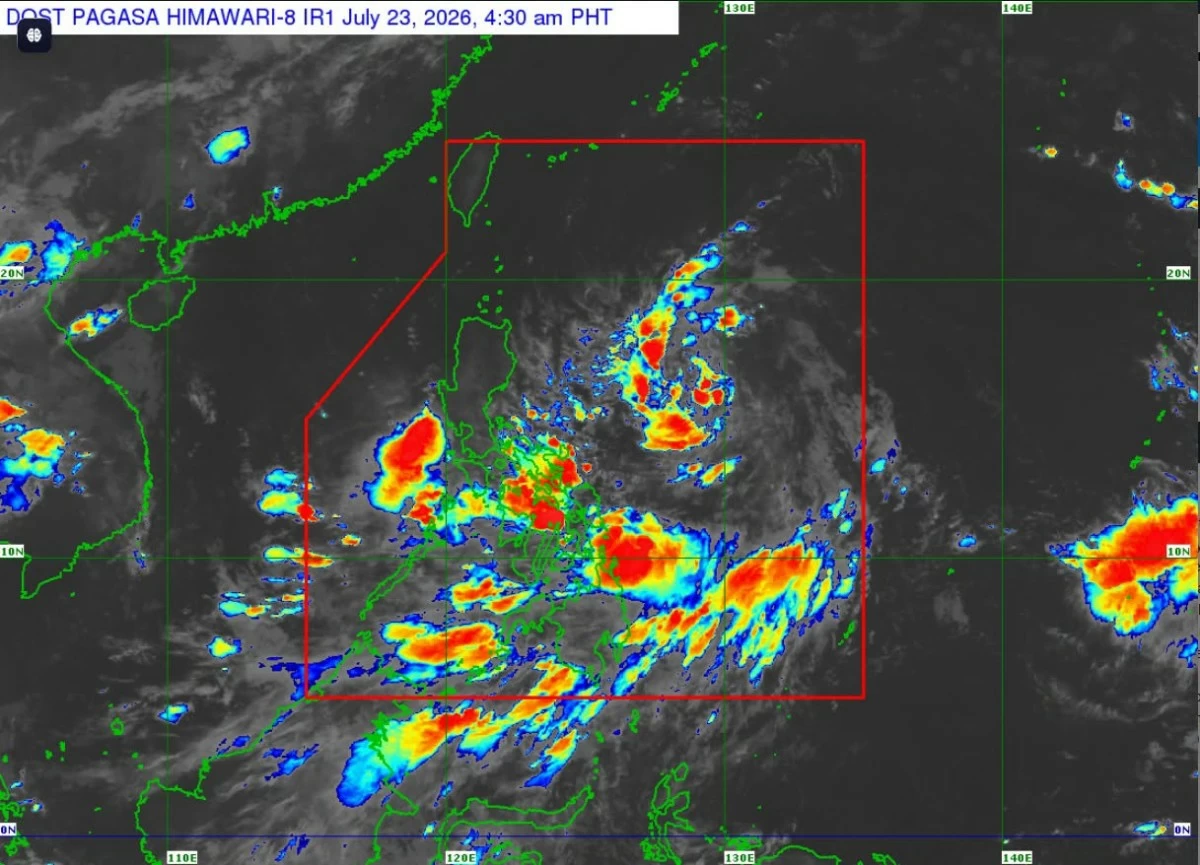
The Philippine Atmospheric, Geophysical and Astronomical Services Administration (PAGASA) on Thursday, July 23, raised Tropical Cyclone Wind Signal No. 1 over 12 areas as Tropical Depression Kiyapo heads toward Luzon.
In its Tropical Cyclone Bulletin No. 2 issued at 5 a.m., PAGASA said Kiyapo was located 950 kilometers east of Central Luzon, with maximum sustained winds of 45 kilometers per hour (kph) near the center and gustiness of up to 55 kph.
It was moving west northwestward at 20 kph.
The following areas are under Signal No. 1, where minimal to minor impacts from strong winds are possible:
Batanes, Cagayan including the Babuyan Islands, Isabela, Apayao, Abra, Kalinga, the eastern and central portions of Mountain Province, the eastern and central portions of Ifugao, Ilocos Norte, the northern portion of Ilocos Sur, and the northern portion of Aurora.
PAGASA said the highest wind signal that may be raised during Kiyapo's passage is Signal No. 2.
However, it did not rule out the possibility of raising Signal No. 3 if Kiyapo intensifies into a severe tropical storm while traversing the Batanes-Babuyan Islands area.
PAGASA said Kiyapo is expected to gradually intensify while moving over the Philippine Sea and may reach tropical storm category by Friday, July 24.
It may continue strengthening while traversing extreme Northern Luzon and may intensify into a severe tropical storm after passing the Babuyan Islands.
PAGASA weather specialist Chenel Dominguez said the southwest monsoon or “habagat” and the trough or extension of Kiyapo remains the dominant weather systems as of Thursday morning.
“As of Thursday, the habagat is affecting the western section of Luzon and the Visayas, and the entire Mindanao. We expect some areas in the Visayas and Mindanao, including Palawan, to experience rains due to the habagat,” Dominguez said.
She said Kiyapo remains far from land, but its trough is expected to bring scattered rains over Bicol Region, Eastern Visayas, and Romblon.
“Metro Manila and the rest of Luzon will experience partly cloudy to cloudy conditions with isolated rain showers or localized thunderstorms, especially in the afternoon and evening,” Dominguez said.
‘Kiyapo’ may pass near Cagayan
PAGASA said Tropical Depression Kiyapo is expected to continue moving west-northwestward until Saturday, July 25, toward the Luzon Strait before turning northwestward for the rest of the forecast period.
Based on the forecast track, its center may pass very close to northeastern mainland Cagayan between Friday morning and afternoon.
It may then pass very close to or make landfall over the Babuyan Islands between Friday afternoon and evening.
Kiyapo is expected to exit the Philippine Area of Responsibility by Saturday morning or noon.
It may weaken once it makes landfall near southern mainland China and moves farther inland.
Strong winds, rough seas expected
PAGASA said the southwest monsoon, enhanced by Kiyapo, will bring strong-to-gale-force gusts over several areas.
On Thursday, strong-to-gale-force gusts are expected over most of Mindanao, Siquijor, Bohol, and Southern Leyte.
By Friday, most of the country may experience strong-to-gale-force gusts, while on Saturday, these conditions are expected over most of Luzon, most of Visayas, Zamboanga Peninsula, Misamis Occidental, Camiguin, Dinagat Islands, and Davao Oriental.
PAGASA also said it may issue a gale warning over the seaboards of extreme Northern Luzon on Thursday or early Friday morning.
Wave heights of up to three meters are expected along the eastern seaboard of Davao Oriental, prompting PAGASA to advise small sea vessels, including motorbancas, not to venture out under these conditions.
Moderate to rough seas are also expected along several other coastal areas, including the eastern seaboards of Batanes, Cagayan, Isabela, Eastern Samar, and Dinagat Islands, as well as the western seaboards of Maguindanao, Sultan Kudarat, and Sarangani and the seaboards of Davao Occidental.
PAGASA advised operators of motorbancas and similarly sized vessels to take precautionary measures and, if possible, avoid sailing under these conditions.

Related Tags

PAGASA TROPICAL DEPRESSION KIYAPO SIGNAL NO. 3 SIGNAL NO. 1 LANDFALL HABAGAT
ADVERTISEMENT
.most-popular .layout-ratio{ padding-bottom: 79.13%; } @media (min-width: 768px) and (max-width: 1024px) { .widget-title { font-size: 15px !important; } }

{{ articles_filter_1561_widget.title }}

.most-popular .layout-ratio{ padding-bottom: 79.13%; } @media (min-width: 768px) and (max-width: 1024px) { .widget-title { font-size: 15px !important; } }

{{ static_articles_1562_widget.title }}

.most-popular .layout-ratio{ padding-bottom: 79.13%; } @media (min-width: 768px) and (max-width: 1024px) { .widget-title { font-size: 15px !important; } }

{{ articles_filter_1563_widget.title }}

{{ articles_filter_1564_widget.title }}

.mb-article-details { position: relative; } .mb-article-details .article-body-preview, .mb-article-details .article-body-summary{ font-size: 17px; line-height: 30px; font-family: "Libre Caslon Text", serif; color: #000; } .mb-article-details .article-body-preview iframe , .mb-article-details .article-body-summary iframe{ width: 100%; margin: auto; } .read-more-background { background: linear-gradient(180deg, color(display-p3 1.000 1.000 1.000 / 0) 13.75%, color(display-p3 1.000 1.000 1.000 / 0.8) 30.79%, color(display-p3 1.000 1.000 1.000) 72.5%); position: absolute; height: 200px; width: 100%; bottom: 0; display: flex; justify-content: center; align-items: center; padding: 0; } .read-more-background a{ color: #000; } .read-more-btn { padding: 17px 45px; font-family: Inter; font-weight: 700; font-size: 18px; line-height: 16px; text-align: center; vertical-align: middle; border: 1px solid black; background-color: white; } .hidden { display: none; }
function initializeAllSwipers() { // Get all hidden inputs with cms_article_id document.querySelectorAll('[id^="cms_article_id_"]').forEach(function (input) { const cmsArticleId = input.value; const articleSelector = '#article-' + cmsArticleId + ' .body_images'; const swiperElement = document.querySelector(articleSelector); if (swiperElement && !swiperElement.classList.contains('swiper-initialized')) { new Swiper(articleSelector, { loop: true, pagination: false, navigation: { nextEl: '#article-' + cmsArticleId + ' .swiper-button-next', prevEl: '#article-' + cmsArticleId + ' .swiper-button-prev', }, }); } }); } setTimeout(initializeAllSwipers, 3000); const intersectionObserver = new IntersectionObserver( (entries) => { entries.forEach((entry) => { if (entry.isIntersecting) { const newUrl = entry.target.getAttribute("data-url"); if (newUrl) { history.pushState(null, null, newUrl); let article = entry.target; // Extract metadata const author = article.querySelector('.author-section').textContent.replace('By', '').trim(); const section = article.querySelector('.section-info ').textContent.replace(' ', ' '); const title = article.querySelector('.article-title h1').textContent; // Parse URL for Chartbeat path format const parsedUrl = new URL(newUrl, window.location.origin); const cleanUrl = parsedUrl.host + parsedUrl.pathname; // Update Chartbeat configuration if (typeof window._sf_async_config !== 'undefined') { window._sf_async_config.path = cleanUrl; window._sf_async_config.sections = section; window._sf_async_config.authors = author; } // Track virtual page view with Chartbeat if (typeof pSUPERFLY !== 'undefined' && typeof pSUPERFLY.virtualPage === 'function') { try { pSUPERFLY.virtualPage({ path: cleanUrl, title: title, sections: section, authors: author }); } catch (error) { console.error('ping error', error); } } // Optional: Update document title if (title && title !== document.title) { document.title = title; } } } }); }, { threshold: 0.1 } ); function showArticleBody(button) { const article = button.closest("article"); const summary = article.querySelector(".article-body-summary"); const body = article.querySelector(".article-body-preview"); const readMoreSection = article.querySelector(".read-more-background"); // Hide summary and read-more section summary.style.display = "none"; readMoreSection.style.display = "none"; // Show the full article body body.classList.remove("hidden"); } document.addEventListener("DOMContentLoaded", () => { let loadCount = 0; // Track how many times articles are loaded const offset = [1, 2, 3, 4, 5, 6, 7, 8, 9, 10]; // Offset values const currentUrl = window.location.pathname.substring(1); let isLoading = false; // Prevent multiple calls if (!currentUrl) { console.log("Current URL is invalid."); return; } const sentinel = document.getElementById("load-more-sentinel"); if (!sentinel) { console.log("Sentinel element not found."); return; } function isSentinelVisible() { const rect = sentinel.getBoundingClientRect(); return ( rect.top < window.innerHeight && rect.bottom >= 0 ); } function onScroll() { if (isLoading) return; if (isSentinelVisible()) { if (loadCount >= offset.length) { console.log("Maximum load attempts reached."); window.removeEventListener("scroll", onScroll); return; } isLoading = true; const currentOffset = offset[loadCount]; window.loadMoreItems().then(() => { let article = document.querySelector('#widget_1690 > div:nth-last-of-type(2) article'); intersectionObserver.observe(article) loadCount++; }).catch(error => { console.error("Error loading more items:", error); }).finally(() => { isLoading = false; }); } } window.addEventListener("scroll", onScroll); });

Sign up by email to receive news.