

ADVERTISEMENT

'Kiyapo' may intensify into a tropical storm, traverse extreme Northern Luzon—PAGASA

Published Jul 23, 2026 01:33 pm

At A Glance

  • Tropical Depression Kiyapo is expected to further strengthen while traversing extreme Northern Luzon and may intensify into a severe tropical storm after passing the Babuyan Islands.
  • PAGASA said the highest wind signal that may be raised throughout Kiyapo's passage is Signal No. 2, but Signal No. 3 cannot be ruled out if it intensifies into a severe tropical storm.
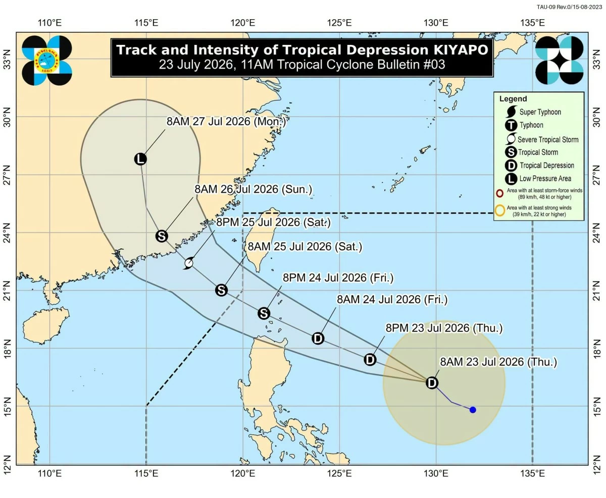
Tropical Depression Kiyapo’s track and intensity forecast (PAGASA)
Tropical Depression Kiyapo is expected to intensify into a tropical storm as it approaches extreme Northern Luzon on Friday, July 24, the Philippine Atmospheric, Geophysical and Astronomical Services Administration (PAGASA) said.
As of 10 a.m., Thursday, July 23, the center of Kiyapo was located 830 kilometers east of Northern Luzon, with maximum sustained winds of 45 kilometers per hour (kph) near the center and gustiness of up to 55 kph.
It was moving northwestward at 25 kph.
‘Kiyapo’ to pass near Cagayan, Babuyan Islands
On the forecast track, Kiyapo may pass very close to the northeastern portion of mainland Cagayan between Friday morning and afternoon before passing very close to or making landfall over the Babuyan Islands between Friday afternoon and evening.
It is expected to move west-northwest toward the Luzon Strait until Saturday, July 25, before turning northwestward for the remainder of the forecast period.
It may exit the Philippine Area of Responsibility by Saturday morning or noon, July 25.
The cyclone is expected to further strengthen while traversing extreme Northern Luzon and may intensify into a severe tropical storm after passing the Babuyan Islands.
A tropical storm has maximum wind speeds of 62 to 86 kph, while a severe tropical storm has maximum wind speeds of 87 to 117 kph.
Signal No. 3 not ruled out
PAGASA said the highest wind signal that may be raised throughout Kiyapo's passage is Signal No. 2.
However, it said Signal No. 3 cannot be ruled out if Kiyapo intensifies into a severe tropical storm while traversing the Batanes-Babuyan Islands area.
Signal No. 1 is currently in effect over Batanes, Cagayan including the Babuyan Islands, Isabela, Apayao, Abra, Kalinga, the eastern and central portions of Mountain Province, the eastern and central portions of Ifugao, Ilocos Norte, the northern portion of Ilocos Sur, the northern portion of Aurora, the northern portion of Quirino, and the northernmost portion of Nueva Vizcaya.
Areas under Signal No. 1 may experience minimal to minor impacts from strong winds.
Heavy rain seen over Northern Luzon
Due to Kiyapo, heavy to intense rainfall of 100 to 200 millimeters may affect Cagayan, Apayao, Abra, Ilocos Norte, and Ilocos Sur on Friday.
Moderate to heavy rainfall of 50 to 100 millimeters may also prevail over Batanes, Isabela, Kalinga, Benguet, and La Union.
The enhanced southwest monsoon or “habagat” may also bring moderate to heavy rainfall over Palawan, Antique, Iloilo, Guimaras, and Negros Occidental.
The approaching weather system may also bring rain to Metro Manila, with thunderstorms becoming more likely on Friday and Saturday, according to PAGASA weather specialist Dr. John Manalo.
“Sa Metro Manila, simula po bukas ay mas dadami po yung kaulapan na posibleng magdulot na mga pag-ulan as compared to today and then sa mga nakaraang araw” (In Metro Manila, starting tomorrow, there will be more cloud cover that may bring rain compared to today and the past few days),” he said in a press conference.
Metro Manila is expected to have partly cloudy conditions on Sunday, although isolated thunderstorms may still occur.
Manalo warned that well-developed thunderstorms may cause widespread flooding, particularly in low-lying and urbanized areas, even if the rain lasts only for a short time.
“Kapag po kahit panandalian lang yung mga ulan na yan, pero kung solid, well-developed po yung mga thunderstorm na yan, possibly po yan magdulot ng mga malawakang mga pagbaha, lalo na dun sa mga low-lying areas at sa mga urbanized areas (Even if the rain lasts only for a short time, if the thunderstorms are solid and well-developed, they could possibly cause widespread flooding, especially in low-lying and urbanized areas),” he added.
PAGASA said Kiyapo is expected to weaken once it makes landfall over China.

Related Tags

PAGASA TROPICAL DEPRESSION KIYAPO HABAGAT SIGNAL NO. 1 SIGNAL NO. 2
ADVERTISEMENT
.most-popular .layout-ratio{ padding-bottom: 79.13%; } @media (min-width: 768px) and (max-width: 1024px) { .widget-title { font-size: 15px !important; } }

{{ articles_filter_1561_widget.title }}

.most-popular .layout-ratio{ padding-bottom: 79.13%; } @media (min-width: 768px) and (max-width: 1024px) { .widget-title { font-size: 15px !important; } }

{{ static_articles_1562_widget.title }}

.most-popular .layout-ratio{ padding-bottom: 79.13%; } @media (min-width: 768px) and (max-width: 1024px) { .widget-title { font-size: 15px !important; } }

{{ articles_filter_1563_widget.title }}

{{ articles_filter_1564_widget.title }}

.mb-article-details { position: relative; } .mb-article-details .article-body-preview, .mb-article-details .article-body-summary{ font-size: 17px; line-height: 30px; font-family: "Libre Caslon Text", serif; color: #000; } .mb-article-details .article-body-preview iframe , .mb-article-details .article-body-summary iframe{ width: 100%; margin: auto; } .read-more-background { background: linear-gradient(180deg, color(display-p3 1.000 1.000 1.000 / 0) 13.75%, color(display-p3 1.000 1.000 1.000 / 0.8) 30.79%, color(display-p3 1.000 1.000 1.000) 72.5%); position: absolute; height: 200px; width: 100%; bottom: 0; display: flex; justify-content: center; align-items: center; padding: 0; } .read-more-background a{ color: #000; } .read-more-btn { padding: 17px 45px; font-family: Inter; font-weight: 700; font-size: 18px; line-height: 16px; text-align: center; vertical-align: middle; border: 1px solid black; background-color: white; } .hidden { display: none; }
function initializeAllSwipers() { // Get all hidden inputs with cms_article_id document.querySelectorAll('[id^="cms_article_id_"]').forEach(function (input) { const cmsArticleId = input.value; const articleSelector = '#article-' + cmsArticleId + ' .body_images'; const swiperElement = document.querySelector(articleSelector); if (swiperElement && !swiperElement.classList.contains('swiper-initialized')) { new Swiper(articleSelector, { loop: true, pagination: false, navigation: { nextEl: '#article-' + cmsArticleId + ' .swiper-button-next', prevEl: '#article-' + cmsArticleId + ' .swiper-button-prev', }, }); } }); } setTimeout(initializeAllSwipers, 3000); const intersectionObserver = new IntersectionObserver( (entries) => { entries.forEach((entry) => { if (entry.isIntersecting) { const newUrl = entry.target.getAttribute("data-url"); if (newUrl) { history.pushState(null, null, newUrl); let article = entry.target; // Extract metadata const author = article.querySelector('.author-section').textContent.replace('By', '').trim(); const section = article.querySelector('.section-info ').textContent.replace(' ', ' '); const title = article.querySelector('.article-title h1').textContent; // Parse URL for Chartbeat path format const parsedUrl = new URL(newUrl, window.location.origin); const cleanUrl = parsedUrl.host + parsedUrl.pathname; // Update Chartbeat configuration if (typeof window._sf_async_config !== 'undefined') { window._sf_async_config.path = cleanUrl; window._sf_async_config.sections = section; window._sf_async_config.authors = author; } // Track virtual page view with Chartbeat if (typeof pSUPERFLY !== 'undefined' && typeof pSUPERFLY.virtualPage === 'function') { try { pSUPERFLY.virtualPage({ path: cleanUrl, title: title, sections: section, authors: author }); } catch (error) { console.error('ping error', error); } } // Optional: Update document title if (title && title !== document.title) { document.title = title; } } } }); }, { threshold: 0.1 } ); function showArticleBody(button) { const article = button.closest("article"); const summary = article.querySelector(".article-body-summary"); const body = article.querySelector(".article-body-preview"); const readMoreSection = article.querySelector(".read-more-background"); // Hide summary and read-more section summary.style.display = "none"; readMoreSection.style.display = "none"; // Show the full article body body.classList.remove("hidden"); } document.addEventListener("DOMContentLoaded", () => { let loadCount = 0; // Track how many times articles are loaded const offset = [1, 2, 3, 4, 5, 6, 7, 8, 9, 10]; // Offset values const currentUrl = window.location.pathname.substring(1); let isLoading = false; // Prevent multiple calls if (!currentUrl) { console.log("Current URL is invalid."); return; } const sentinel = document.getElementById("load-more-sentinel"); if (!sentinel) { console.log("Sentinel element not found."); return; } function isSentinelVisible() { const rect = sentinel.getBoundingClientRect(); return ( rect.top < window.innerHeight && rect.bottom >= 0 ); } function onScroll() { if (isLoading) return; if (isSentinelVisible()) { if (loadCount >= offset.length) { console.log("Maximum load attempts reached."); window.removeEventListener("scroll", onScroll); return; } isLoading = true; const currentOffset = offset[loadCount]; window.loadMoreItems().then(() => { let article = document.querySelector('#widget_1690 > div:nth-last-of-type(2) article'); intersectionObserver.observe(article) loadCount++; }).catch(error => { console.error("Error loading more items:", error); }).finally(() => { isLoading = false; }); } } window.addEventListener("scroll", onScroll); });

Sign up by email to receive news.