






Manila Bulletin
 Philippines
National
'Inday' weakens into typhoon but 12 areas still under Storm Signal 1
Philippines
National
'Inday' weakens into typhoon but 12 areas still under Storm Signal 1
Philippines
National
'Inday' weakens into typhoon but 12 areas still under Storm Signal 1
'Inday' weakens into typhoon but 12 areas still under Storm Signal 1
Published Jul 9, 2026 08:34 am


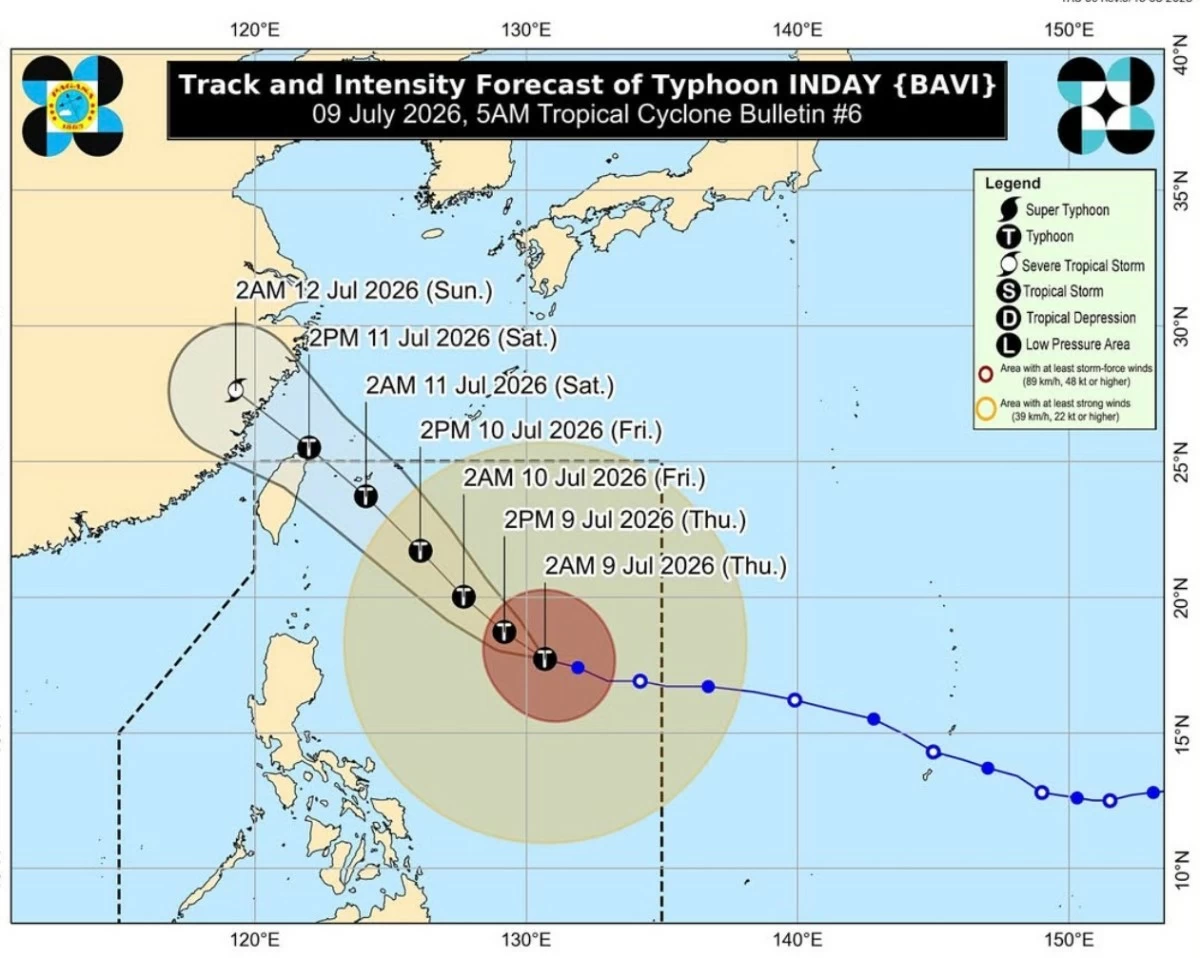
Screenshot
At least 12 provinces are still under storm signal number 1 even if “Inday” has already weakened into typhoon on Thursday morning, the Philippine Atmospheric Geophysical and Astronomical Services Administration (Pagasa) said.
In its tropical cyclone bulletin issued at 5 a.m. on Thursday, Pagasa said the weather disturbance has weakened and is now packing maximum sustained winds of 175 kilometer per hour.
It was last monitored at 925 kilometers east of northern Luzon and moving at 20 kilometers per hour.
Storm signal number 1 is in effect over the following areas:
· Batanes
· Cagayan including Babuyan Islands, Isabela
the northeastern portion of Quirino (Maddela)
· Apayao,
· The northern portion of Abra (Tineg, Lagayan, Danglas, San Juan, Lagangilang, Licuan-Baay, Malibcong, Lacub, Daguioman, Dolores, La Paz)
· Kalinga
· The eastern portion of Mountain Province (Natonin, Paracelis)
· The eastern portion of Ifugao (Aguinaldo, Alfonso Lista)
· Ilocos Norte
· The northern portion of Aurora (Dilasag, Casiguran)
· The northern and central portions of Catanduanes (Pandan, Caramoran, Bagamanoc, Panganiban, Viga, Gigmoto, Baras, San Miguel)
Pagasa said local winds may be slightly stronger/enhanced in coastal and upland/mountainous areas exposed to winds, adding that winds are less strong in areas sheltered from the prevailing wind direction.
The highest Wind Signal that may be hoisted throughout the passage of “Inday” is Wind Signal No. 2 but so far, no areas are still under that storm signal.
And despite the monitored weakening of “Inday’, weather experts said the weather disturbance will bring strong to gale-force gusts in most part of the country from Thursday to Saturday.
Weather experts also warned of rough sea conditions especially in areas near Inday.
Pagasa said “Inday” is forecast to move northwestward while remaining over the Philippine Sea and may pass closest to Extreme Northern Luzon between Friday evening and Saturday morning.
Afterwards, it will move toward the southern islands of Japan and may make landfall or pass close over the northern coast of Taiwan.
Pagasa said “Inday” is expected to exit the country’s area of responsibility by Saturday and make landfall over the eastern coast of mainland China by Sunday.
“Inday is forecast to gradually weaken but will remain as a typhoon until it exits the PAR. It will then weaken into a severe tropical storm after moving further inland over mainland China,” Pagasa said.
“As Inday moves over the sea east of Taiwan, a faster weakening trend is not ruled out due to increasingly unfavorable environment,” it added.