






Manila Bulletin
 Philippines
National
Here comes 'Inday': More areas under Signal Number 1 as super typhoon enters PH
Philippines
National
Here comes 'Inday': More areas under Signal Number 1 as super typhoon enters PH
Philippines
National
Here comes 'Inday': More areas under Signal Number 1 as super typhoon enters PH
Here comes 'Inday': More areas under Signal Number 1 as super typhoon enters PH
Published Jul 8, 2026 05:47 am


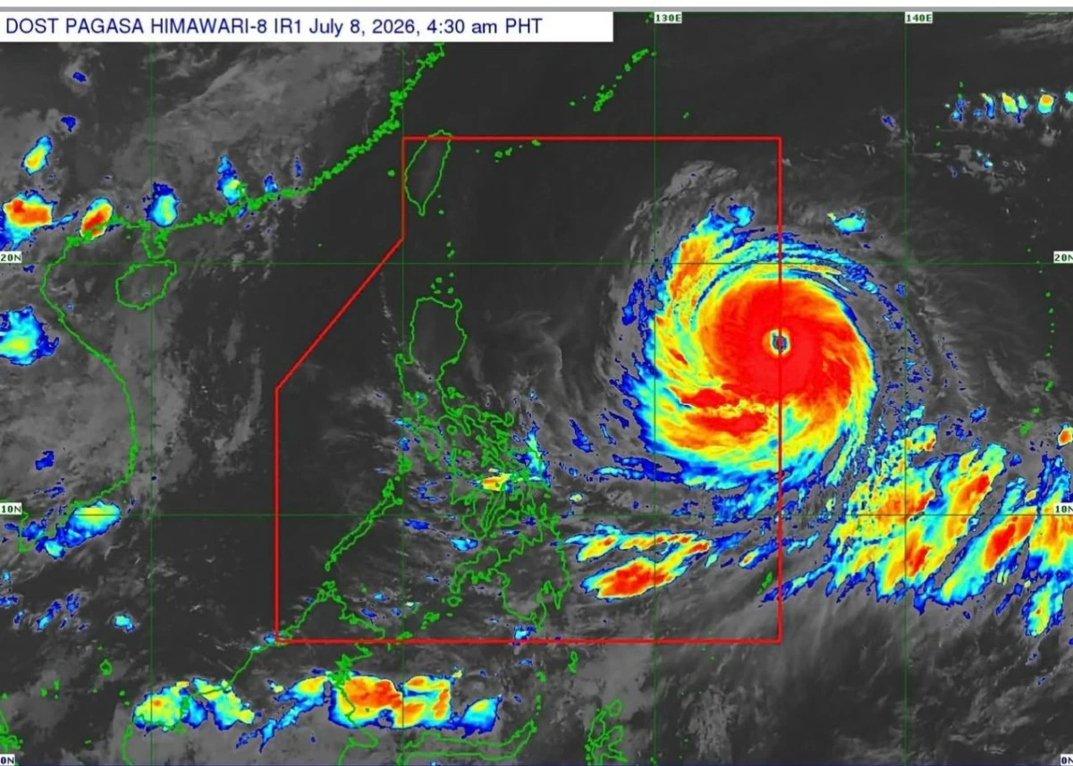
The super typhoon that was being monitored in the past few days has already entered the Philippine area of responsibility and was named “Inday” and triggered hoisting of storm signal in several parts of the country.
In its 5 a.m. report, the Philippine Atmospheric Geophysical and Astronomical Services Administration (PAGASA) said the super typhoon entered the country at 3 a.m. and packing maximum sustained winds of 185 kilometer per hour(kph) near the center, gustiness of up to 230 kph.
It is currently at 1,405 km East of Northern Luzon and slightly accelerated as it is now moving 25 kph westward from the previous 20kph.
While “Inday” will not likely make a landfall, it is expected to unleash strong winds intensify ‘habagat” to bring more rains in various parts of the country.
At least five towns in the province of Cagayan were placed under Storm Signal number 1 as of 11 p.m. on Tuesday.
This morning, July 8, more areas were placed under strom Signal Numbe 1 as the super tyhoon continues to inch closer towards the country’s landmass.
These areas are under Signal number 1 as of 5 a.m. on July 8:
1. Batanes
2. Cagayan including Babuyan Islands
3. the northern and central portions of Isabela (Santo Tomas, Aurora, Santa Maria, Quezon, San Mariano, Naguilian, Dinapigue, Roxas, Luna, Delfin Albano, City of Cauayan, San Pablo, Ilagan City, Benito Soliven, Tumauini, Cabagan, Reina Mercedes, San Manuel, Palanan, Cabatuan, Quirino, Divilacan, Gamu, Mallig, Maconacon, Burgos, San Guillermo, Angadanan, Alicia, San Mateo)
4. Apayao
5. the eastern portion of Kalinga (Pinukpuk, City of Tabuk, Rizal)
6. the northern portion of Aurora (Dilasag)
7. and the northern and central portions of Catanduanes (Pandan, Caramoran, Bagamanoc, Panganiban, Viga, Gigmoto, Baras, San Miguel)
The highest Wind Signal that may be hoisted throughout Inda’s passage is Wind Signal No. 2 or 3, but so far, no areas were declared under that.
Wind signal
The areas placed under signal number 1 will experience winds speeds from 39 to 61 km/h but experts said there is minimal to minor threat to life and property.
Pagasa, however, warned the public of the general wind threat, local winds may be slightly stronger/enhanced in coastal and upland/mountainous areas exposed to winds.
“Winds are less strong in areas sheltered from the prevailing wind direction,” it said.
Pagasa said the enhanced Southwest Monsoon (habagat) and the periphery of Super Typhoon Inday will bring strong to gale-force gusts in the following areas:
• July 8: Pangasinan, Zambales, Bataan, CALABARZON, most of MIMAROPA, Bicol Region, most of Visayas, and most of Mindanao.
July 9: Most of the country.
July 10: Most of the country.
Heavy rains
In a weather advisory released at 5 a.m. Wednesday, Pagasa also identified areas that will experience heavy rains as a result of the weather disturbance.
For July 8, Sultan Kudarat and Sarangani will experience rains with 50mm to 100mm which is classified as moderate to heavy. The same rain forecast will be experienced in Occidental Mindoro, Palawan, Antique, and Negros Occidental on Thursday, July 9.
On Friday, the following areas will experience moderate to intense rains:
1. Batanes
2. Occidental Mindoro and Antique (heavy to intense)
3. Zambales, Bataan, Metro Manila, Cavite, Batangas, Palawan, Guimaras, Iloilo, Negros Occidental, Negros Oriental, Lanao del Norte, and Lanao del Sur (moderate to heavy)
“Forecast rainfall may be higher in mountainous and elevated areas. Moreover, impacts in some areas may be worsened by significant antecedent rainfall,” Pagasa said.
Rough seas
Pagasa also warned of rough seas over the following coastal waters:
• Up to 4.5 m: The seaboard of Isabela; the northern seaboard of Aurora; the northern and eastern seaboards of Catanduanes; the eastern seaboard of Northern Samar.
• Up to 4.0 m: The northern and eastern seaboards of Batanes and Polillo Islands; the eastern seaboards of Cagayan, Albay, Sorsogon, Eastern Samar, and Dinagat Islands; the remaining seaboard of Aurora; the northern seaboards of mainland Quezon, Camarines Norte, Camarines Sur, and Northern Samar.
• Up to 3.5 m: The remaining seaboards of Batanes and Cagayan; the eastern seaboards of Bucas Grande-Siargao Islands, and Surigao del Sur; the eastern and southern seaboards of Davao Oriental.
• Up to 2.5 m: The southern seaboard of Southern Leyte; the remaining seaboards of Surigao del Norte; the southeastern seaboard of Davao Occidental; the northern and western seaboards of Kalayaan Islands.
• Up to 2.0 m: The southern seaboard of Bohol; the northern seaboard of Camiguin; the remaining seaboards of Kalayaan Islands.
Other coastal waters have forecast wave heights of less than 2.0 m.