

ADVERTISEMENT

PAGASA: Super Typhoon Bavi may trigger wind signals, bring rains by midweek

Once inside the PAR, it will be given the local name 'Inday'

Published Jul 5, 2026 10:04 am  |  Updated Jul 5, 2026 02:05 pm

At A Glance

  • PAGASA weather specialist Obet Badrina said the tropical cyclone is expected to enter the Philippine Area of Responsibility (PAR) on Wednesday morning, while maintaining its super typhoon strength.
  • Although landfall remains unlikely, Badrina said the super typhoon's large circulation could prompt the raising of tropical cyclone wind signals over the northern and eastern portions of Northern Luzon as early as Tuesday evening or Wednesday morning.
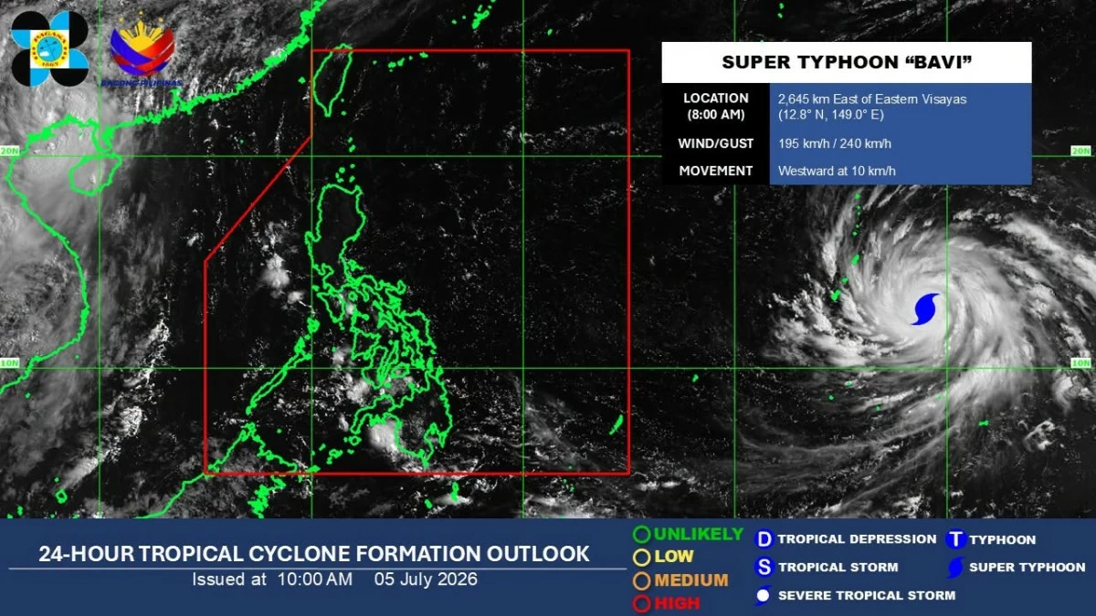
Satellite image of Super Typhoon Bavi outside the Philippine area of responsibility (PAR). Once inside the PAR, it will be given the local name “Inday.” (PAGASA)
The Philippine Atmospheric, Geophysical and Astronomical Services Administration (PAGASA) on Sunday, July 5, warned that approaching Super Typhoon Bavi could trigger tropical cyclone wind signals and bring rains across parts of the country starting Wednesday, July 8.
As of 8 a.m. Sunday, the super typhoon was located 2,645 kilometers east of Eastern Visayas, packing maximum sustained winds of 195 kilometers per hour (kph) near the center and gusts of up to 240 kph.
PAGASA weather specialist Obet Badrina said the tropical cyclone is expected to enter the Philippine Area of Responsibility (PAR) on Wednesday morning while maintaining its super typhoon strength.
Once inside the PAR, it will be given the local name “Inday.”
Badrina said the cyclone is expected to continue moving west-northwestward and remains less likely to make landfall over the Philippine landmass.
“Sa ngayon po, kung sakali man na kikilos po ito pa kanluran-hilagang kanluran, medyo maliit pa rin ‘yung posibilidad na ito ay tumama sa kalupaan ng ating bansa. Posible po, medyo lalapit lang ito sa may area ng Batanes, at ito po ay tutungo sa bahagi naman ng Taiwan (If it continues moving west-northwestward, the possibility of making landfall in the country remains low. It is expected to pass near Batanes before heading toward Taiwan),” he said.
However, Badrina said the super typhoon's large circulation could prompt the raising of tropical cyclone wind signals over the northern and eastern portions of Northern Luzon as early as Tuesday evening or Wednesday morning.
He added that the combined effects of the tropical cyclone and the enhanced southwest monsoon, or “habagat,” may bring scattered rains as early as Wednesday over parts of the Visayas and Mindanao, with heavy rains expected over the northern and western portions of the country by Thursday, July 9.
“Asahan po natin na palalakasin nito ang habagat, kaya posible po, medyo magiging maulan itong paparating na linggo sa malaking bahagi, lalo na ng Luzon at Visayas, bandang araw po ng Miyerkules o Huwebes hanggang weekend na po next week (We expect it to enhance the southwest monsoon, so much of the country, especially Luzon and the Visayas, may experience rainy weather from Wednesday or Thursday through next weekend),” he said.
Badrina also said gusty conditions are likely to begin affecting most parts of the country between Tuesday and Wednesday.
He added that a gale warning is expected to be issued over the country's eastern seaboards, prohibiting small vessels from venturing out to sea due to hazardous marine conditions.

Related Tags

PAGASA SUPER TYPHOON BAVI SUPER TYPHOON INDAY HABAGAT TROPICAL CYCLONE WIND SIGNAL
ADVERTISEMENT
.most-popular .layout-ratio{ padding-bottom: 79.13%; } @media (min-width: 768px) and (max-width: 1024px) { .widget-title { font-size: 15px !important; } }

{{ articles_filter_1561_widget.title }}

.most-popular .layout-ratio{ padding-bottom: 79.13%; } @media (min-width: 768px) and (max-width: 1024px) { .widget-title { font-size: 15px !important; } }

{{ static_articles_1562_widget.title }}

.most-popular .layout-ratio{ padding-bottom: 79.13%; } @media (min-width: 768px) and (max-width: 1024px) { .widget-title { font-size: 15px !important; } }

{{ articles_filter_1563_widget.title }}

{{ articles_filter_1564_widget.title }}

.mb-article-details { position: relative; } .mb-article-details .article-body-preview, .mb-article-details .article-body-summary{ font-size: 17px; line-height: 30px; font-family: "Libre Caslon Text", serif; color: #000; } .mb-article-details .article-body-preview iframe , .mb-article-details .article-body-summary iframe{ width: 100%; margin: auto; } .read-more-background { background: linear-gradient(180deg, color(display-p3 1.000 1.000 1.000 / 0) 13.75%, color(display-p3 1.000 1.000 1.000 / 0.8) 30.79%, color(display-p3 1.000 1.000 1.000) 72.5%); position: absolute; height: 200px; width: 100%; bottom: 0; display: flex; justify-content: center; align-items: center; padding: 0; } .read-more-background a{ color: #000; } .read-more-btn { padding: 17px 45px; font-family: Inter; font-weight: 700; font-size: 18px; line-height: 16px; text-align: center; vertical-align: middle; border: 1px solid black; background-color: white; } .hidden { display: none; }
function initializeAllSwipers() { // Get all hidden inputs with cms_article_id document.querySelectorAll('[id^="cms_article_id_"]').forEach(function (input) { const cmsArticleId = input.value; const articleSelector = '#article-' + cmsArticleId + ' .body_images'; const swiperElement = document.querySelector(articleSelector); if (swiperElement && !swiperElement.classList.contains('swiper-initialized')) { new Swiper(articleSelector, { loop: true, pagination: false, navigation: { nextEl: '#article-' + cmsArticleId + ' .swiper-button-next', prevEl: '#article-' + cmsArticleId + ' .swiper-button-prev', }, }); } }); } setTimeout(initializeAllSwipers, 3000); const intersectionObserver = new IntersectionObserver( (entries) => { entries.forEach((entry) => { if (entry.isIntersecting) { const newUrl = entry.target.getAttribute("data-url"); if (newUrl) { history.pushState(null, null, newUrl); let article = entry.target; // Extract metadata const author = article.querySelector('.author-section').textContent.replace('By', '').trim(); const section = article.querySelector('.section-info ').textContent.replace(' ', ' '); const title = article.querySelector('.article-title h1').textContent; // Parse URL for Chartbeat path format const parsedUrl = new URL(newUrl, window.location.origin); const cleanUrl = parsedUrl.host + parsedUrl.pathname; // Update Chartbeat configuration if (typeof window._sf_async_config !== 'undefined') { window._sf_async_config.path = cleanUrl; window._sf_async_config.sections = section; window._sf_async_config.authors = author; } // Track virtual page view with Chartbeat if (typeof pSUPERFLY !== 'undefined' && typeof pSUPERFLY.virtualPage === 'function') { try { pSUPERFLY.virtualPage({ path: cleanUrl, title: title, sections: section, authors: author }); } catch (error) { console.error('ping error', error); } } // Optional: Update document title if (title && title !== document.title) { document.title = title; } } } }); }, { threshold: 0.1 } ); function showArticleBody(button) { const article = button.closest("article"); const summary = article.querySelector(".article-body-summary"); const body = article.querySelector(".article-body-preview"); const readMoreSection = article.querySelector(".read-more-background"); // Hide summary and read-more section summary.style.display = "none"; readMoreSection.style.display = "none"; // Show the full article body body.classList.remove("hidden"); } document.addEventListener("DOMContentLoaded", () => { let loadCount = 0; // Track how many times articles are loaded const offset = [1, 2, 3, 4, 5, 6, 7, 8, 9, 10]; // Offset values const currentUrl = window.location.pathname.substring(1); let isLoading = false; // Prevent multiple calls if (!currentUrl) { console.log("Current URL is invalid."); return; } const sentinel = document.getElementById("load-more-sentinel"); if (!sentinel) { console.log("Sentinel element not found."); return; } function isSentinelVisible() { const rect = sentinel.getBoundingClientRect(); return ( rect.top < window.innerHeight && rect.bottom >= 0 ); } function onScroll() { if (isLoading) return; if (isSentinelVisible()) { if (loadCount >= offset.length) { console.log("Maximum load attempts reached."); window.removeEventListener("scroll", onScroll); return; } isLoading = true; const currentOffset = offset[loadCount]; window.loadMoreItems().then(() => { let article = document.querySelector('#widget_1690 > div:nth-last-of-type(2) article'); intersectionObserver.observe(article) loadCount++; }).catch(error => { console.error("Error loading more items:", error); }).finally(() => { isLoading = false; }); } } window.addEventListener("scroll", onScroll); });

Sign up by email to receive news.