


Manila Bulletin
 Philippines
National
LPA west of Bataan develops into Tropical Depression Henry; Signal No. 1 up
Philippines
National
LPA west of Bataan develops into Tropical Depression Henry; Signal No. 1 up
Philippines
National
LPA west of Bataan develops into Tropical Depression Henry; Signal No. 1 up
LPA west of Bataan develops into Tropical Depression Henry; Signal No. 1 up
Published Jul 1, 2026 07:08 am


At A Glance
- In its Tropical Cyclone Bulletin No. 1 issued at 5 a.m., PAGASA raised Tropical Cyclone Wind Signal No. 1 over the southwestern portion of Zambales (San Antonio, Castillejos, Subic, and Olongapo City), western portion of Bataan (Morong, Bagac, and Mariveles), and Lubang Islands.
PAGASA
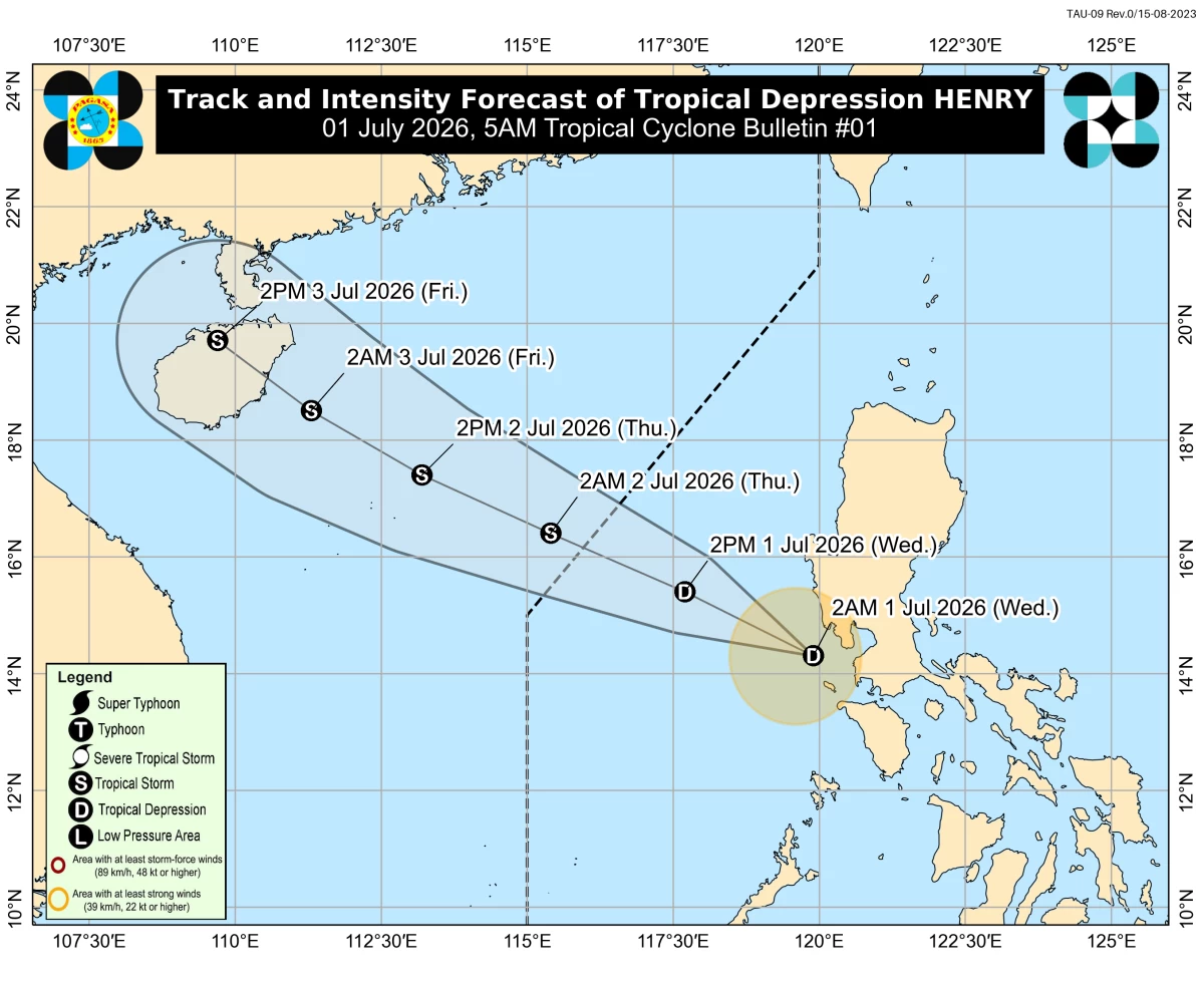
The low-pressure area (LPA) west of Central Luzon has intensified into a tropical depression on Wednesday morning, July 1, and was given the local name “Henry,” said the Philippine Atmospheric, Geophysical and Astronomical Services Administration (PAGASA).
In its Tropical Cyclone Bulletin No. 1 issued at 5 a.m., PAGASA raised Tropical Cyclone Wind Signal No. 1 over the southwestern portion of Zambales (San Antonio, Castillejos, Subic, and Olongapo City), western portion of Bataan (Morong, Bagac, and Mariveles), and Lubang Islands.
PAGASA said minimal to minor impacts from strong winds are possible in areas under Signal No. 1.
Moderate to heavy rains may also prevail over Zambales and Bataan.
Meanwhile, scattered rains and thunderstorms may persist in Metro Manila, Cavite, Laguna, Batangas, Rizal, Quezon, Bulacan, Tarlac, Pampanga, Oriental Mindoro, Occidental Mindoro, and Marinduque.
The center of Henry was estimated at 115 kilometers west-southwest of Abucay, Bataan, with maximum sustained winds of 45 kilometers per hour (kph) near the center and gustiness of up to 55 kph.
It was moving northwestward at 25 kph.
Henry-enhanced ‘habagat’
PAGASA warned that the outer circulation of Henry and the enhanced southwest monsoon, or “habagat,” will continue to bring strong to gale-force wind gusts, especially in coastal and mountainous areas.
For Wednesday, these gusts may affect Batanes, Cagayan, Ilocos Norte, Pangasinan, Tarlac, Nueva Ecija, Pampanga, Bulacan, Metro Manila, Calabarzon, Occidental Mindoro, and Palawan.
Scattered rains and thunderstorms may also persist in Romblon, Palawan, Western Visayas, Negros Island Region, Central Visayas, Zamboanga Peninsula, Bangsamoro Autonomous Region in Muslim Mindanao, Lanao del Norte, Misamis Oriental, and Misamis Occidental.
PAGASA also advised mariners of motorbancas and similarly sized vessels to take precautionary measures or avoid sailing over affected waters due to moderate sea conditions.
Wave heights of up to 2.5 meters are expected over the seaboards of Cagayan and Isabela and the western seaboards of Zambales, Bataan, and Lubang Islands, while waves of up to 2 meters are forecast over the seaboards of Aurora and Batanes, the northern seaboard of Ilocos Norte, and the western seaboards of La Union, Pangasinan, and Palawan.
Forecast track, intensity
Henry is expected to move generally west-northwestward while gradually moving away from the Philippine landmass.
It may exit the Philippine Area of Responsibility (PAR) by Thursday morning, July 2.
PAGASA said the tropical depression is expected to gradually intensify over the West Philippine Sea and may reach tropical storm category by Thursday morning.
It may remain a tropical storm for the rest of the forecast period.