


Manila Bulletin
 Philippines
National
LPA still likely to develop into tropical depression within 24 hours, enhance 'habagat' — PAGASA
Philippines
National
LPA still likely to develop into tropical depression within 24 hours, enhance 'habagat' — PAGASA
Philippines
National
LPA still likely to develop into tropical depression within 24 hours, enhance 'habagat' — PAGASA
LPA still likely to develop into tropical depression within 24 hours, enhance 'habagat' — PAGASA
Published Jun 30, 2026 05:21 pm


At A Glance
- Should the LPA intensify into a tropical depression while inside the Philippine Area of Responsibility (PAR), it will be assigned the local name "Henry."
- PAGASA weather specialist Benison Estareja said the weather disturbance is expected to cross the remaining parts of Mimaropa before emerging over the West Philippine Sea on Wednesday, July 1.
PAGASA
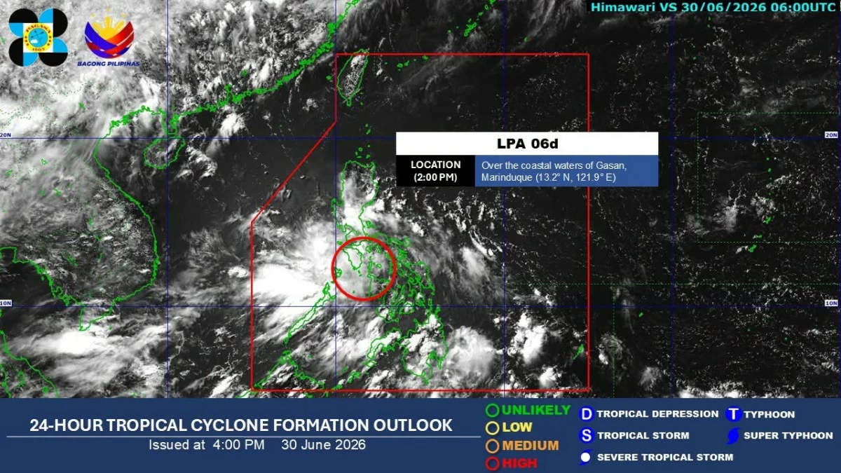
The low-pressure area (LPA) moving across Southern Luzon remains likely to develop into a tropical depression within the next 24 hours, the Philippine Atmospheric, Geophysical and Astronomical Services Administration (PAGASA) said on Tuesday, June 30.
PAGASA weather specialist Benison Estareja said the weather disturbance is expected to cross the remaining parts of Mimaropa before emerging over the West Philippine Sea on Wednesday, July 1.
At 3 p.m., the LPA was over the coastal waters of Gasan, Marinduque.
Should the LPA intensify into a tropical depression while inside the Philippine Area of Responsibility (PAR), it will be assigned the local name “Henry,” Estareja said.
Although it has yet to develop into a tropical depression, the LPA has already been bringing widespread rains over parts of Luzon and Visayas.
Once it strengthens further, Estareja said, the weather system is expected to enhance the southwest monsoon or “habagat,” and bring more rain to several parts of the country.
Over the next 24 hours, PAGASA said Metro Manila, Visayas, Central Luzon, Calabarzon, Mimaropa, and Bicol Region will experience scattered rains and thunderstorms due to the LPA.
The habagat may also bring scattered rains and thunderstorms over Zamboanga Peninsula, Bangsamoro Autonomous Region in Muslim Mindanao, Lanao del Norte, Sultan Kudarat, South Cotabato, Sarangani, Davao Occidental, Davao del Sur, and Davao Oriental.
The rest of Mindanao will have partly cloudy to cloudy skies with isolated rain showers or thunderstorms due to the habagat, while the rest of Luzon will experience partly cloudy to cloudy skies with isolated rain showers or thunderstorms caused by localized thunderstorms.
PAGASA warned that moderate to, at times, heavy rains and severe thunderstorms may cause flash floods or landslides.
Meanwhile, Estareja said PAGASA is not monitoring any potential low-pressure area that could develop within the next three days.