


Manila Bulletin
 Philippines
National
Only Batanes remains under Signal No. 1 as 'Francisco' nears PAR exit
Philippines
National
Only Batanes remains under Signal No. 1 as 'Francisco' nears PAR exit
Philippines
National
Only Batanes remains under Signal No. 1 as 'Francisco' nears PAR exit
Only Batanes remains under Signal No. 1 as 'Francisco' nears PAR exit
Published Jun 25, 2026 09:14 am


At A Glance
- Severe Tropical Storm Francisco is expected to exit the Philippine Area of Responsibility (PAR) this afternoon or evening.
- Meanwhile, the tropical storm with the international name "Higos" may graze the PAR on Thursday evening before exiting Friday morning.
- If it enters the PAR, it will be given the local name "Gardo."
PAGASA
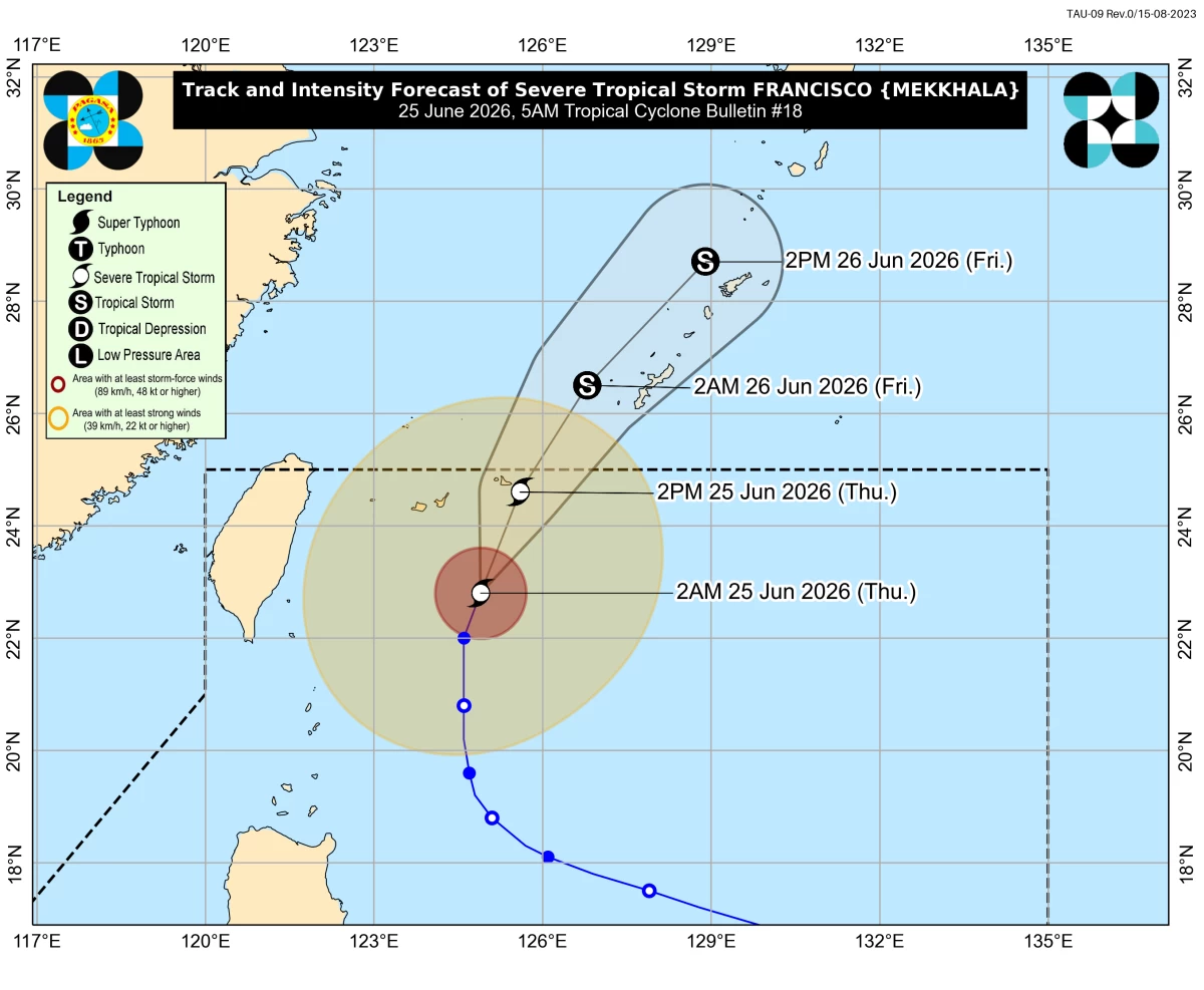
Severe Tropical Storm Francisco (international name: Mekkhala) accelerated north-northeastward on Thursday, June 25, and is expected to leave the country’s area of responsibility within the day, the Philippine Atmospheric, Geophysical and Astronomical Services Administration (PAGASA) said.
In its 5 a.m. tropical cyclone bulletin, PAGASA said Francisco was estimated at 415 kilometers northeast of Itbayat, Batanes.
The storm further weakened, with maximum sustained winds of 100 kilometers per hour (kph) near the center, gusts of up to 125 kph, and a north-northeastward movement of 15 kph.
Only Batanes remained under Tropical Cyclone Wind Signal No. 1, where winds of 39 to 61 kph may pose a minimal to minor threat to life and property.
“Francisco will continue moving generally northeastward towards the Ryukyu Islands and sea south of mainland Japan throughout the forecast period,” PAGASA said.
“On the track forecast, Francisco will exit the Philippine Area of Responsibility (PAR) this afternoon or evening (June 25),” it added.
PAGASA said the storm is expected to continue weakening and may be downgraded into a tropical storm by Friday, June 26.
While Francisco moves away from the country, the southwest monsoon and the storm’s outer circulation may still bring strong to gale-force gusts over large parts of Luzon.
On Thursday, these conditions may affect most of Luzon, Panay Island, Negros Occidental, and Northern Samar.
By Friday, strong winds may be experienced in Batanes, Ilocos Region, Apayao, Cagayan, Isabela, Central Luzon, Metro Manila, Calabarzon, Occidental Mindoro, Oriental Mindoro, Romblon, Marinduque, Camarines Norte, and Camarines Sur.
PAGASA also warned of rough seas of up to 3.5 meters along the northern and eastern seaboards of Batanes.
“Mariners of small seacrafts, including all types of motorbancas, are advised not to venture out to sea under these conditions, especially if inexperienced or operating ill-equipped vessels,” the weather bureau said.
Moderate sea conditions were also forecast over the remaining coastal waters of Batanes, Babuyan Islands, Ilocos Norte, mainland Cagayan, Isabela, Aurora, Ilocos Sur, La Union, Zambales, Lubang Island, the Kalayaan Islands, Polillo Islands, Catanduanes, Camarines Norte, Camarines Sur, Pangasinan, Bataan, and Batangas.
Meanwhile, the tropical storm with the international name “Higos” was estimated at 1,750 kilometers east of Central Luzon.
It has maximum sustained winds of 75 kph near the center and gustiness of up to 90 kph.
The storm was moving west-northwestward at 20 kph and may graze the PAR on Thursday evening before exiting Friday morning.
If it enters the PAR, it will be given the local name “Gardo.”