






Manila Bulletin
 Philippines
National
PAGASA expects 9 to 13 tropical cyclones until December amid El Niño
Philippines
National
PAGASA expects 9 to 13 tropical cyclones until December amid El Niño
Philippines
National
PAGASA expects 9 to 13 tropical cyclones until December amid El Niño
PAGASA expects 9 to 13 tropical cyclones until December amid El Niño
Published Jun 24, 2026 02:38 pm


At A Glance
- El Niño years are often associated with increased tropical cyclone activity during July and stronger storms later in the year.
PAGASA
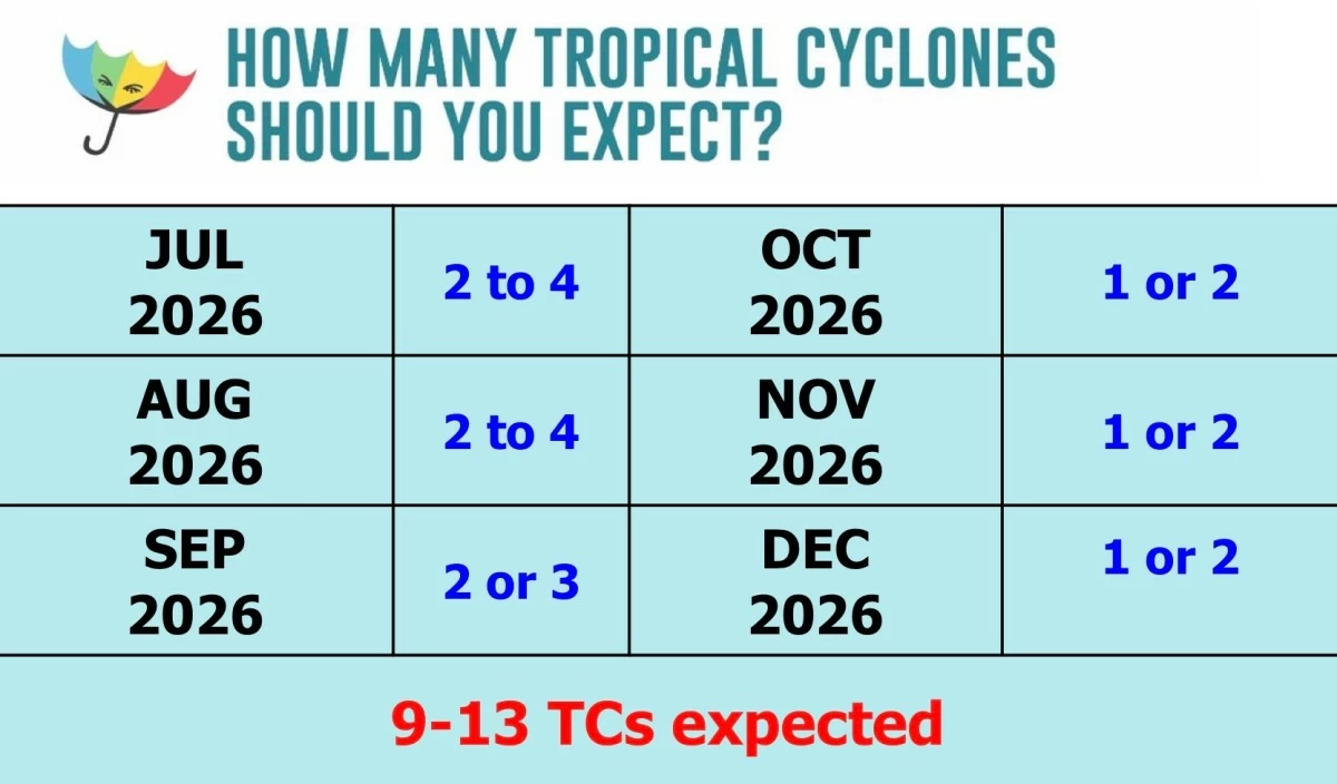
The Philippine Atmospheric, Geophysical and Astronomical Services Administration (PAGASA) said nine to 13 tropical cyclones may develop or enter the Philippine Area of Responsibility (PAR) from July to December.
Speaking during a climate forum on Wednesday, June 24, PAGASA-Climate and Agrometeorology Division Assistant Weather Services Chief Ana Liza Solis said two to four tropical cyclones are expected in July, another two to four in August, and two to three in September.
The weather bureau also forecasts one to two tropical cyclones each in October, November, and December.
The forecast comes as El Niño conditions continue in the tropical Pacific. PAGASA issued its first El Niño advisory on June 9 and has said the climate phenomenon is expected to strengthen in the coming months and persist into next year.
Solis said El Niño years are often associated with increased tropical cyclone activity during July and stronger storms later in the year.
“Historically speaking po kasi, kapag merong El Niño mas marami po tayong bagyo during the month of July. At mas maraming typhoon at super typhoon category during the latter part of the year (Historically, when there is an El Niño, we tend to have more tropical cyclones during the month of July. We also see more storms reaching typhoon and super typhoon categories during the latter part of the year),” Solis said.
“Whether weak, moderate, strong, or very strong ang El Niño ay mostly ay typhoon at super typhoon category ang ating posibleng maranasan na strength ng ating mga bagyo. We also need to consider ‘yung possible interaction ng El Niño with this tropical cyclone frequency and ‘yun pong ating mga intertropical convergence zone and low-pressure systems (Whether the El Niño is weak, moderate, strong, or very strong, the tropical cyclones we may experience are mostly likely to reach typhoon and super typhoon strength. We also need to consider the possible interaction of El Niño with tropical cyclone frequency, as well as with the intertropical convergence zone and low-pressure systems),” she added.
Despite the developing El Niño, PAGASA said most parts of the country are still likely to experience near- to above-normal rainfall from July to September.
However, some areas in the Visayas and Mindanao may continue to receive below-normal rainfall during the period.
“July to September ay possible pa rin po ‘yung generally near to above normal rainfall conditions in most parts of the country except sa ibang parte ng Visayas and Mindanao na mayroon pa rin pong below normal rainfall (From July to September, most parts of the country may still experience generally near- to above-normal rainfall conditions, except for some areas in the Visayas and Mindanao where below-normal rainfall remains likely),” she said.
The effects of El Niño are expected to become more pronounced toward the end of the year.
“Pagdating po ng October, below to near normal rainfall condition over Central Visayas and Mindanao and pagdating po ng November to December, dito na po ‘yung ating mataas na possibility of way below to below normal rainfall condition na likely to experience over most parts of the country. Nandito po ‘yung nakikita nating impact ng El Niño (By October, Central Visayas and Mindanao may experience below- to near-normal rainfall conditions, while from November to December there is a high possibility that most parts of the country will experience way below- to below-normal rainfall. This is where we expect to see the impacts of El Niño),” she said.