


Manila Bulletin
 Philippines
National
'Francisco' continues to weaken; another storm to briefly enter PAR
Philippines
National
'Francisco' continues to weaken; another storm to briefly enter PAR
Philippines
National
'Francisco' continues to weaken; another storm to briefly enter PAR
'Francisco' continues to weaken; another storm to briefly enter PAR
Published Jun 24, 2026 08:45 am


At A Glance
- Despite remaining far from the country's landmass, Francisco is expected to stay within the PAR until Thursday evening, June 25, or early Friday morning, June 26.
- Meanwhile, a tropical storm is forecast to enter the PAR on Thursday, June 25, and will be assigned the local name "Gardo."
PAGASA
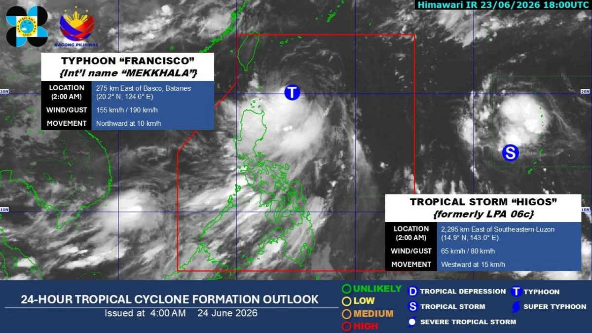
Typhoon Francisco (international name “Mekkhala”) weakened further over the sea east of Batanes on Wednesday, June 24, while another tropical storm is expected to briefly enter the Philippine Area of Responsibility (PAR) later this week, the Philippine Atmospheric, Geophysical and Astronomical Services Administration (PAGASA) said.
As of 4 a.m., the center of Francisco was estimated at 275 kilometers east of Basco, Batanes.
The typhoon was packing maximum sustained winds of 155 kilometers per hour (kph) near the center and gustiness of up to 190 kph while moving northward at 10 kph.
PAGASA weather specialist Chenel Dominguez said Tropical Cyclone Wind Signal No. 1 remains in effect over Batanes and the northeastern portion of Cagayan, particularly Gonzaga and Santa Ana, including the Babuyan Islands.
Under the wind signal, minimal to minor impacts from strong winds are possible.
Francisco is also expected to bring moderate to heavy rains over Batanes and Cagayan, while scattered rains and thunderstorms may affect the Ilocos Region, Cordillera Administrative Region, and the rest of Cagayan Valley.
Francisco-enhanced ‘habagat’
The enhanced southwest monsoon, or “habagat,” may also trigger moderate to heavy rains over Palawan, Occidental Mindoro, and Bataan.
Meanwhile, scattered rains and thunderstorms may prevail over Metro Manila, Central Luzon, Southern Luzon, the Bicol Region, Western Visayas, and the Negros Island Region.
“Habang papalayo si Francisco ay unti-unti ring mababawasan ang mga pag-ulan (As Francisco moves farther away, rainfall will gradually decrease),” Dominguez said.
PAGASA warned that localized flooding and landslides remain possible, especially in areas highly susceptible to these hazards.
Despite remaining far from the Philippine landmass, Francisco is expected to stay within the PAR until Thursday evening, June 25, or early Friday morning, June 26.
“Francisco will continue moving northward until tomorrow morning (June 25) before turning north-northeastward towards the Ryukyu Islands and the sea south of mainland Japan,” PAGASA said in its forecast.
The weather bureau said Francisco is seen to gradually weaken throughout the forecast period, although it will likely remain a typhoon while inside the PAR.
‘Gardo’
Meanwhile, a tropical storm with the international name “Higos” remains outside the PAR as of early Wednesday.
Higos was located 2,285 km east of southeastern Luzon, with maximum sustained winds of 65 kph near the center and gustiness of up to 80 kph. It was moving westward at 15 kph.
Dominguez said the tropical storm is forecast to enter the PAR on Thursday, June 25, and will be assigned the local name “Gardo.”
However, it is expected to exit the PAR by Friday, June 26.
She said Higos will remain far from the country’s landmass and is not expected to directly affect any part of the country.