






Manila Bulletin
 Philippines
National
Typhoon Francisco weakens but still threatens Northern Luzon with rains, strong winds
Philippines
National
Typhoon Francisco weakens but still threatens Northern Luzon with rains, strong winds
Philippines
National
Typhoon Francisco weakens but still threatens Northern Luzon with rains, strong winds
Typhoon Francisco weakens but still threatens Northern Luzon with rains, strong winds
Published Jun 23, 2026 11:50 am


At A Glance
- Despite remaining offshore, PAGASA weather specialist Benison Estareja warned that the outer rain bands of Francisco (Mekkhala) may still bring strong winds and heavy rains over parts of Northern Luzon.
- Another tropical cyclone outside PAR has intensified into a tropical storm and has been given the international name "Higos."
PAGASA
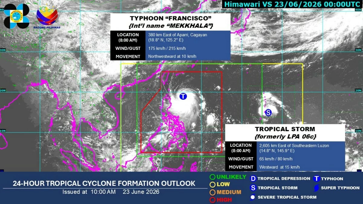
Tropical Cyclone Francisco (international name “Mekkhala) weakened from a super typhoon into a typhoon on Tuesday morning, June 23, but the Philippine Atmospheric, Geophysical and Astronomical Services Administration (PAGASA) warned that its outer rain bands could still bring heavy rains and strong winds over parts of Northern Luzon within the next 24 hours.
As of 10 a.m., Francisco had maximum sustained winds of 175 kilometers per hour (kph) near the center and gustiness of up to 215 kph.
It was located 375 kilometers east-northeast of Aparri, Cagayan, or 380 kilometers east of Calayan, Cagayan.
PAGASA said Francisco may either re-intensify or maintain its strength until Tuesday afternoon before gradually weakening due to increasingly unfavorable environmental conditions.
It is expected to move generally north-northwestward until Wednesday morning, June 24, before recurving toward the Ryukyu Islands in southern Japan.
Based on the forecast track, Francisco is expected to exit the Philippine area of responsibility (PAR) on Friday, June 26.
Francisco, ‘habagat’ bringing strong winds, heavy rains
Despite remaining offshore, PAGASA weather specialist Benison Estareja warned that the outer rain bands of Francisco may still bring strong winds and heavy rains over parts of Northern Luzon.
Tropical Cyclone Wind Signal No. 1 remains in effect over Batanes, northeastern portion of Cagayan (Gonzaga and Santa Ana), and eastern portion of Babuyan Islands (Babuyan Island, Didicas Island, and Camiguin Island).
PAGASA said minimal to minor impacts from strong winds are possible in areas under Wind Signal No. 1.
The weather bureau added that Signal No. 2 may be raised over parts of the Babuyan Islands and Batanes if there is a significant westward shift in the forecast track.
However, it noted that this scenario is becoming less likely as Francisco continues on a more northwestward path.
Moderate to heavy rains are also expected over Batanes, Cagayan, Aurora, and Isabela.
Estareja said Typhoon Francisco is also enhancing the southwest monsoon or “habagat,” which may continue to bring strong to gale-force gusts over much of the country in the next two days.
The habagat will also continue to trigger scattered rains and thunderstorms in Southern Luzon, Bicol Region, Visayas, and Mindanao.
Metro Manila and the rest of Luzon may experience partly cloudy to cloudy skies with isolated rain showers or thunderstorms.
Storm outside PAR
Estareja said another tropical cyclone outside PAR has intensified into a tropical storm and has been given the international name “Higos.”
As of Tuesday morning, Higos was located 2,605 kilometers east of southeastern Luzon, with maximum sustained winds of 65 kph and gustiness of up to 80 kph. It was moving westward at 15 kph.
Estareja said the tropical storm was gradually approaching PAR, but the likelihood of it directly affecting any part of the country in the coming days remains low.