






Manila Bulletin
 Philippines
National
'Francisco' may bring heavy rains to extreme Northern Luzon; enhanced 'habagat' to drench other areas — PAGASA
Philippines
National
'Francisco' may bring heavy rains to extreme Northern Luzon; enhanced 'habagat' to drench other areas — PAGASA
Philippines
National
'Francisco' may bring heavy rains to extreme Northern Luzon; enhanced 'habagat' to drench other areas — PAGASA
'Francisco' may bring heavy rains to extreme Northern Luzon; enhanced 'habagat' to drench other areas — PAGASA
Published Jun 22, 2026 12:57 pm
|
Updated Jun 22, 2026 01:59 pm


At A Glance
- From Tuesday to Thursday, June 23 to 25, Cagayan, Batanes, and Babuyan Islands may receive 50 to 100 millimeters of rainfall, classified as moderate to heavy, due to Typhoon Francisco.
- The southwest monsoon or "habagat" enhanced by Francisco will also continue to bring rains over parts of Southern Luzon, Visayas, and Mindanao.
PAGASA
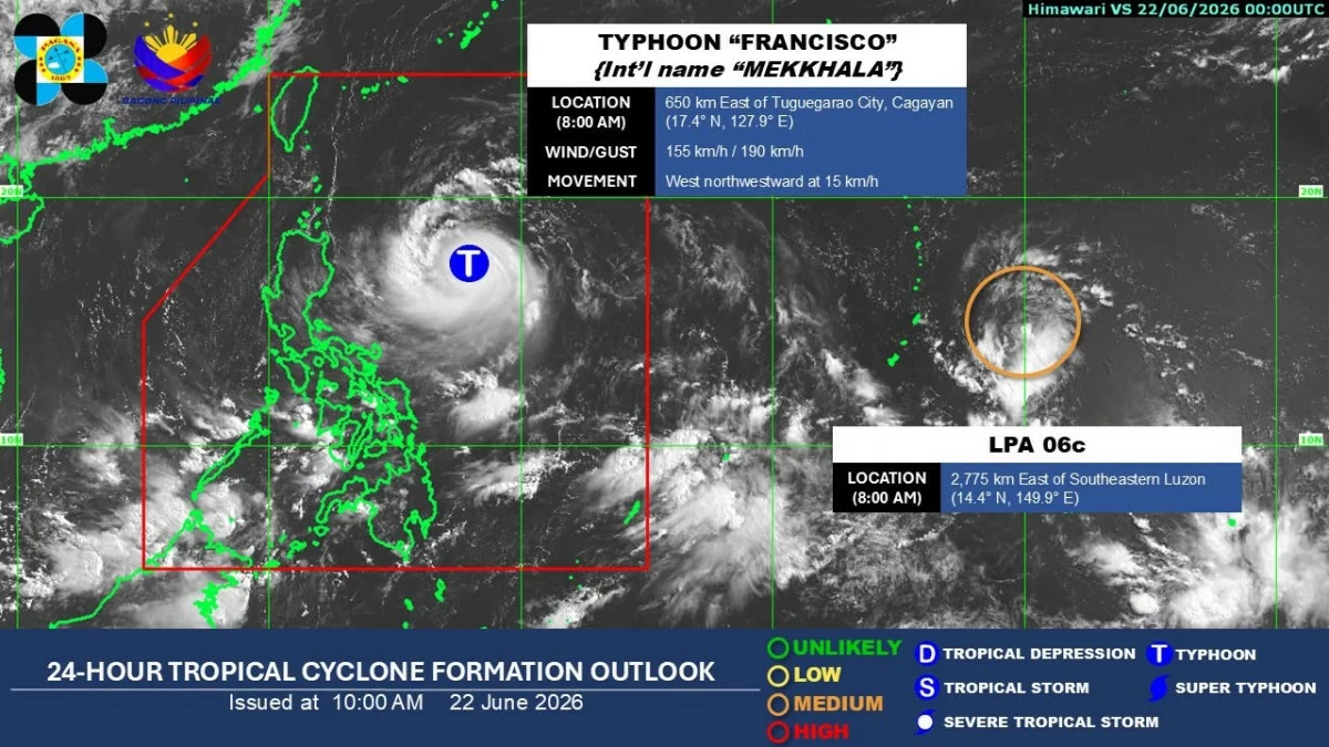
Typhoon Francisco (international name “Mekkhala”) is expected to bring moderate to heavy rains over parts of Northern Luzon, while the southwest monsoon or “habagat” enhanced by the typhoon will continue to affect several areas across the country, the Philippine Atmospheric, Geophysical and Astronomical Services Administration (PAGASA) said on Monday, June 22.
As of 10 a.m., PAGASA said the center of the eye of Typhoon Francisco was estimated at 620 kilometers east of Tuguegarao City, Cagayan.
It was packing maximum sustained winds of 155 kilometers per hour (kph) near the center and gusts of up to 190 kph while moving west-northwestward at 15 kph.
Tropical Cyclone Wind Signal No. 1 remains in effect over Batanes, the northeastern portion of Cagayan (Gonzaga, Santa Ana), and the eastern portion of Babuyan Islands (Babuyan Island, Didicas Island, Camiguin Island).
During a press conference, PAGASA weather specialist Charmagne Varilla said Northern Luzon has yet to experience significant rainfall from the typhoon, while the southwest monsoon continues to prevail over Visayas, Mindanao, and Palawan.
“Makikita po natin dito sa ating satellite animation na wala pa masyadong nararamdaman ngayon na mga pag-ulan, especially dito sa may part ng Northern Luzon. Samantalang southwest monsoon naman o hanging habagat pa rin, ang siyang umiiral sa buong Visayas, Mindanao at Palawan (We can see in our satellite animation that there is still not much rainfall being experienced at the moment, especially in parts of Northern Luzon. Meanwhile, the southwest monsoon or habagat continues to prevail over the whole of Visayas, Mindanao, and Palawan),” she said.
From Tuesday noon to Wednesday noon, June 23 to 24, Varilla said that Cagayan, Batanes, and Babuyan Islands may receive 50 to 100 millimeters of rainfall, classified as moderate to heavy.
These areas may continue to experience moderate to heavy rains until Thursday, June 25.
“So ‘yung ganito pong dami ng mga pagulan, inuulit po natin maaari po yan magdulot na mga localized flooding, especially nga sa mga areas na malapit sa ilog, ‘yung mga areas na nasa low-lying part, at ‘yung mga areas din po na nasa siyudad. Mabilis po, or maaari pong magdulot ‘yan ng mga pagbaha. And pagguho din po ng lupa, especially sa mga very high to high susceptibility areas (With this amount of rainfall, we reiterate that it may cause localized flooding, especially in areas near rivers, low-lying areas, and urban communities. It may quickly lead to flooding and also trigger landslides, particularly in areas with very high to high susceptibility),” she warned.
Typhoon-enhanced ‘habagat’
Varilla said the habagat enhanced by Francisco will continue to bring rains over Visayas, Mindanao, and Palawan over the next three days.
Bicol Region and Mimaropa are also expected to be affected in the coming days, while rainfall over Mindanao may gradually lessen and become concentrated over the western sections, including Zamboanga Peninsula, Basilan, and Tawi-Tawi.
By Thursday, as Francisco moves farther away from the country, the habagat is expected to become the dominant weather system, bringing rains over Bicol Region, Mimaropa, and Western Visayas.
Varilla added that Metro Manila may start to experience the effects of the enhanced habagat by Friday, June 26, as the typhoon exits the Philippine area of responsibility (PAR) and pulls the monsoon farther north toward parts of Luzon.
Peak intensity, closest approach
PAGASA said Typhoon Francisco may reach its peak intensity on Tuesday.
“Nakikita po natin, bukas (June 23) po niya mari-reach ‘yung kanyang peak intensity. Pagsapit naman po ng Miyerkules (June 24), dito naman po natin nakikita yung pagsisimula na ng pagbagal niya, as well as posible nga po na ‘yun na ‘yung closest approach niya, around 275 km east o silangan ng Basco Batanes (We expect it to reach its peak intensity tomorrow, June 23. By Wednesday, June 24, we are seeing the start of its slowing movement, and that may also be its closest approach, around 275 kilometers east of Basco, Batanes),” Varilla said.
She said the typhoon is expected to accelerate on Thursday, as it begins to recurve toward southern Japan.
“Pagsapit naman po ng Thursday (June 25), nakikita po natin na magsisimula na ‘yung pagbilis po ng kanyang pagkilos habang nagre-recurve papunta sa may katimugang bahagi ng Japan. And aside from that, nakikitaan na po din natin ng unti-unti pa niyang paghina (By Thursday, June 25, we expect it to start moving faster as it recurves toward the southern part of Japan. Aside from that, we are also seeing its gradual weakening),” she said.
PAGASA said Francisco is expected to exit PAR by Friday.
LPA outside PAR
Meanwhile, PAGASA is also monitoring a new low-pressure area (LPA) outside PAR.
Varilla said the weather disturbance was last spotted 2,745 kilometers east of southeastern Luzon and currently has a medium chance of developing into a tropical cyclone.
She added that PAGASA is not ruling out the possibility of the system entering PAR based on its tropical cyclone threat potential.