


Manila Bulletin
 Philippines
National
'Francisco' intensifies into a super typhoon; tropical depression forms outside PAR
Philippines
National
'Francisco' intensifies into a super typhoon; tropical depression forms outside PAR
Philippines
National
'Francisco' intensifies into a super typhoon; tropical depression forms outside PAR
'Francisco' intensifies into a super typhoon; tropical depression forms outside PAR
Published Jun 22, 2026 10:23 pm


At A Glance
- Super typhoon Francisco was packing maximum sustained winds of 185 kilometers per hour (kph) near the center and gusts of up to 230 kph while moving west-northwestward at 15 kph.
- Meanwhile, PAGASA said the low-pressure area (LPA 06c) outside the Philippine area of responsibility had developed into a tropical depression.
PAGASA
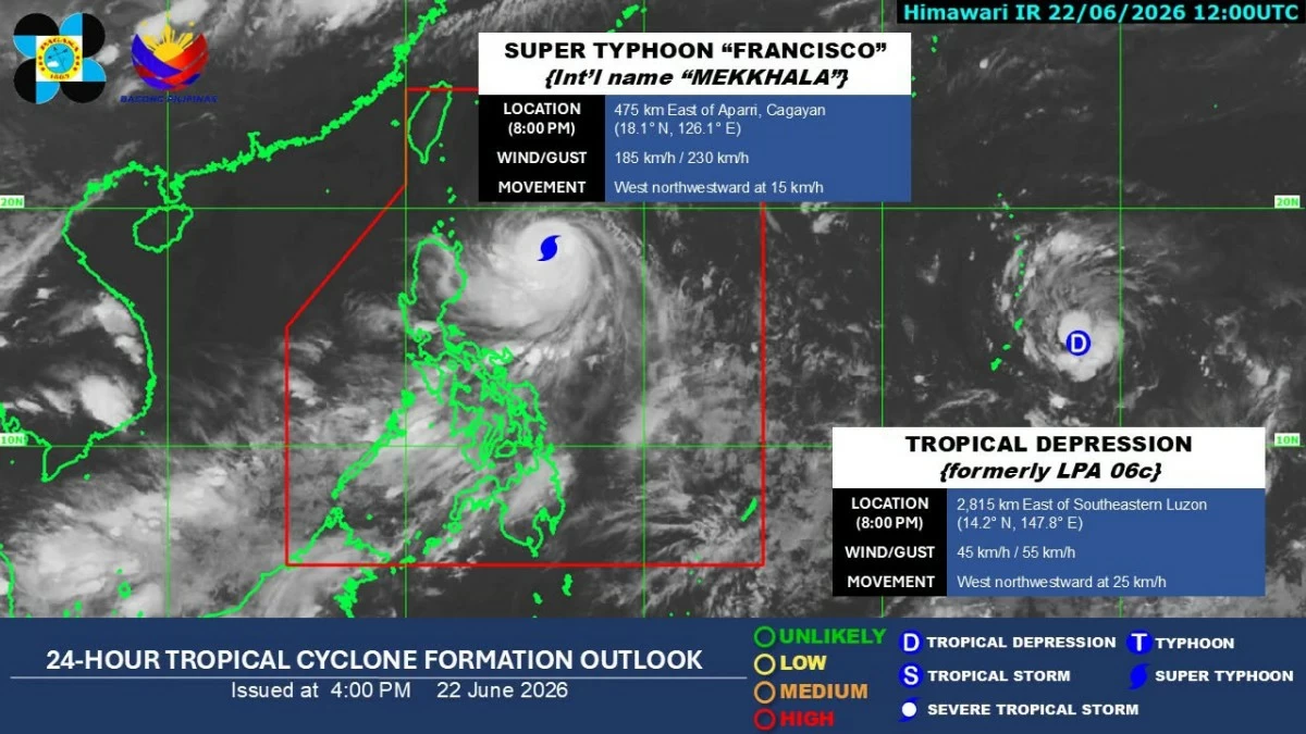
Typhoon Francisco (international name: Mekkhala) has intensified into a super typhoon on Monday evening, June 22, the Philippine Atmospheric, Geophysical and Astronomical Services Administration (PAGASA) said.
As of 8 p.m, the center of the eye of the typhoon was located 475 kilometers east of Aparri, Cagayan.
Francisco was packing maximum sustained winds of 185 kilometers per hour (kph) near the center and gusts of up to 230 kph while moving west-northwestward at 15 kph.
In the 5 p.m. bulletin, Tropical Cyclone Wind Signal No. 1 remains hoisted over Batanes, northeastern portion of Cagayan (Gonzaga and Santa Ana), and eastern portion of the Babuyan Islands (Babuyan Island, Didicas Island, and Camiguin Island).
PAGASA said the highest wind signal likely to be hoisted during Francisco’s passage is Signal No. 2.
Meanwhile, PAGASA said the low-pressure area (LPA 06c) outside the Philippine area of responsibility had developed into a tropical depression.
The tropical depression was located 2,815 kilometers east of southeastern Luzon, with maximum sustained winds of 45 kph near the center and gustiness of up to 55 kph.
It was moving west-northwestward at 25 kph.
PAGASA earlier said it has not ruled out the possibility of the tropical depression entering PAR.