ADVERTISEMENT

'Francisco' now a typhoon; enhanced 'habagat' may trigger heavy rains in the coming days

Published Jun 21, 2026 05:20 pm

At A Glance

  • In its Tropical Cyclone Bulletin No. 4 issued at 5 p.m., PAGASA said Francisco was estimated at 1,055 kilometers east of Central Luzon, packing maximum sustained winds of 120 kilometers per hour (kph) near the center and gustiness of up to 150 kph.
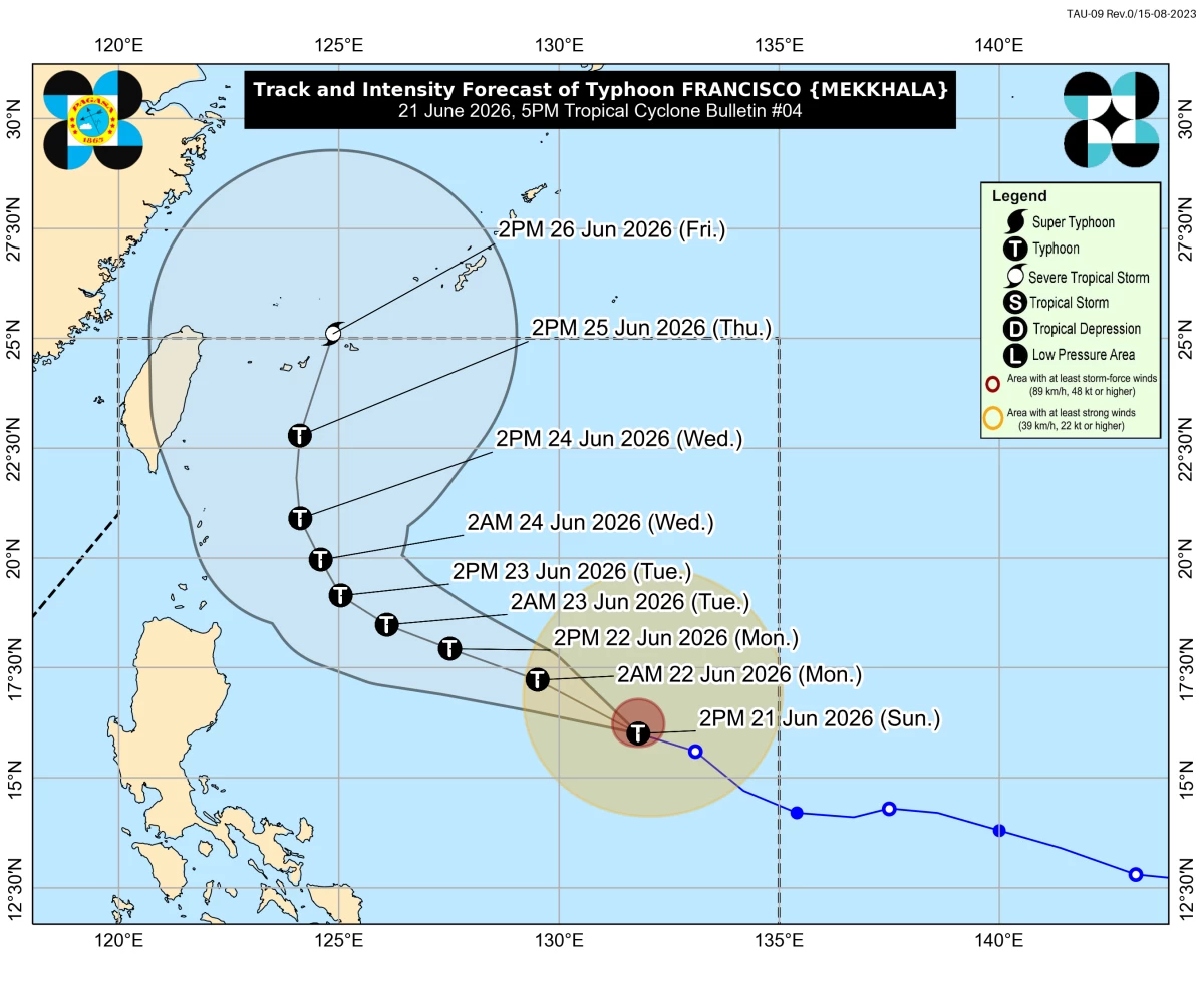
Track and intensity forecast for Typhoon Francisco (international name: Mekkhala) (PAGASA)
Severe Tropical Storm Francisco (international name: Mekkhala) intensified into a typhoon at 2 p.m. on Sunday, June 21, said the Philippine Atmospheric, Geophysical and Astronomical Services Administration (PAGASA).
In its Tropical Cyclone Bulletin No. 4 issued at 5 p.m., PAGASA said Francisco was estimated at 1,055 kilometers east of Central Luzon, packing maximum sustained winds of 120 kilometers per hour (kph) near the center and gustiness of up to 150 kph.
Although the typhoon remains far from land and is not expected to directly affect the country’s weather on Sunday, PAGASA said its circulation could enhance the southwest monsoon or “habagat” in the coming days.
“Francisco is less likely to directly affect the weather conditions in the country today. However, onset of heavy rains due to the enhanced southwest monsoon is possible beginning tomorrow (June 22),” PAGASA said.
The weather bureau added that a weather advisory may be issued either Sunday or Monday, June 21 or 22, in anticipation of heavy rains over Northern Luzon and some areas in the western portions of Luzon and Visayas.
Wind warnings
No tropical cyclone wind signal was in effect as of Sunday afternoon.
However, PAGASA said Signal No. 1 may be raised by Monday morning in some localities in the northern and eastern portions of Cagayan, including the Babuyan Islands, as well as Batanes.
Francisco was moving west-northwestward at 25 kph and is forecast to remain over the Philippine Sea throughout the forecast period.
“However, a closer approach to extreme Northern Luzon is not ruled out should the forecast track continue to shift westward,” PAGASA said.
The typhoon is expected to continue moving west-northwestward until Wednesday, June 24, before slowing down and curving toward southern Japan.
PAGASA also said Francisco may continue intensifying and could reach its peak strength by Tuesday, June 23, before gradually weakening afterward.

Related Tags

PAGASA TYPHOON FRANCISCO MEKKHALA SIGNAL NO. 1 HABAGAT SOUTHWEST MONSOON
ADVERTISEMENT
.most-popular .layout-ratio{ padding-bottom: 79.13%; } @media (min-width: 768px) and (max-width: 1024px) { .widget-title { font-size: 15px !important; } }

{{ articles_filter_1561_widget.title }}

.most-popular .layout-ratio{ padding-bottom: 79.13%; } @media (min-width: 768px) and (max-width: 1024px) { .widget-title { font-size: 15px !important; } }

{{ static_articles_1562_widget.title }}

.most-popular .layout-ratio{ padding-bottom: 79.13%; } @media (min-width: 768px) and (max-width: 1024px) { .widget-title { font-size: 15px !important; } }

{{ articles_filter_1563_widget.title }}

{{ articles_filter_1564_widget.title }}

.mb-article-details { position: relative; } .mb-article-details .article-body-preview, .mb-article-details .article-body-summary{ font-size: 17px; line-height: 30px; font-family: "Libre Caslon Text", serif; color: #000; } .mb-article-details .article-body-preview iframe , .mb-article-details .article-body-summary iframe{ width: 100%; margin: auto; } .read-more-background { background: linear-gradient(180deg, color(display-p3 1.000 1.000 1.000 / 0) 13.75%, color(display-p3 1.000 1.000 1.000 / 0.8) 30.79%, color(display-p3 1.000 1.000 1.000) 72.5%); position: absolute; height: 200px; width: 100%; bottom: 0; display: flex; justify-content: center; align-items: center; padding: 0; } .read-more-background a{ color: #000; } .read-more-btn { padding: 17px 45px; font-family: Inter; font-weight: 700; font-size: 18px; line-height: 16px; text-align: center; vertical-align: middle; border: 1px solid black; background-color: white; } .hidden { display: none; }
function initializeAllSwipers() { // Get all hidden inputs with cms_article_id document.querySelectorAll('[id^="cms_article_id_"]').forEach(function (input) { const cmsArticleId = input.value; const articleSelector = '#article-' + cmsArticleId + ' .body_images'; const swiperElement = document.querySelector(articleSelector); if (swiperElement && !swiperElement.classList.contains('swiper-initialized')) { new Swiper(articleSelector, { loop: true, pagination: false, navigation: { nextEl: '#article-' + cmsArticleId + ' .swiper-button-next', prevEl: '#article-' + cmsArticleId + ' .swiper-button-prev', }, }); } }); } setTimeout(initializeAllSwipers, 3000); const intersectionObserver = new IntersectionObserver( (entries) => { entries.forEach((entry) => { if (entry.isIntersecting) { const newUrl = entry.target.getAttribute("data-url"); if (newUrl) { history.pushState(null, null, newUrl); let article = entry.target; // Extract metadata const author = article.querySelector('.author-section').textContent.replace('By', '').trim(); const section = article.querySelector('.section-info ').textContent.replace(' ', ' '); const title = article.querySelector('.article-title h1').textContent; // Parse URL for Chartbeat path format const parsedUrl = new URL(newUrl, window.location.origin); const cleanUrl = parsedUrl.host + parsedUrl.pathname; // Update Chartbeat configuration if (typeof window._sf_async_config !== 'undefined') { window._sf_async_config.path = cleanUrl; window._sf_async_config.sections = section; window._sf_async_config.authors = author; } // Track virtual page view with Chartbeat if (typeof pSUPERFLY !== 'undefined' && typeof pSUPERFLY.virtualPage === 'function') { try { pSUPERFLY.virtualPage({ path: cleanUrl, title: title, sections: section, authors: author }); } catch (error) { console.error('ping error', error); } } // Optional: Update document title if (title && title !== document.title) { document.title = title; } } } }); }, { threshold: 0.1 } ); function showArticleBody(button) { const article = button.closest("article"); const summary = article.querySelector(".article-body-summary"); const body = article.querySelector(".article-body-preview"); const readMoreSection = article.querySelector(".read-more-background"); // Hide summary and read-more section summary.style.display = "none"; readMoreSection.style.display = "none"; // Show the full article body body.classList.remove("hidden"); } document.addEventListener("DOMContentLoaded", () => { let loadCount = 0; // Track how many times articles are loaded const offset = [1, 2, 3, 4, 5, 6, 7, 8, 9, 10]; // Offset values const currentUrl = window.location.pathname.substring(1); let isLoading = false; // Prevent multiple calls if (!currentUrl) { console.log("Current URL is invalid."); return; } const sentinel = document.getElementById("load-more-sentinel"); if (!sentinel) { console.log("Sentinel element not found."); return; } function isSentinelVisible() { const rect = sentinel.getBoundingClientRect(); return ( rect.top < window.innerHeight && rect.bottom >= 0 ); } function onScroll() { if (isLoading) return; if (isSentinelVisible()) { if (loadCount >= offset.length) { console.log("Maximum load attempts reached."); window.removeEventListener("scroll", onScroll); return; } isLoading = true; const currentOffset = offset[loadCount]; window.loadMoreItems().then(() => { let article = document.querySelector('#widget_1690 > div:nth-last-of-type(2) article'); intersectionObserver.observe(article) loadCount++; }).catch(error => { console.error("Error loading more items:", error); }).finally(() => { isLoading = false; }); } } window.addEventListener("scroll", onScroll); });

Sign up by email to receive news.