

ADVERTISEMENT

PAGASA warns of widespread 'habagat' rains as potential typhoon nears PAR

Published Jun 19, 2026 06:16 pm

At A Glance

  • PAGASA weather specialist Loriedin dela Cruz-Galicia said the tropical depression was not directly affecting any part of the country as of Friday.
  • However, she said there is a high chance the cyclone will enhance the habagat once it enters the Philippine Area of Responsibility (PAR) this weekend.
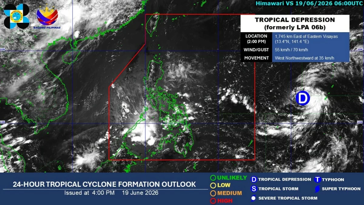
Satellite image of a tropical depression outside the Philippine area of responsibility (PAGASA)
A tropical depression east of the Philippines could enhance the southwest monsoon or “habagat” and bring rains over large parts of the country starting Sunday, June 21, the Philippine Atmospheric, Geophysical and Astronomical Services Administration (PAGASA) (PAGASA) said on Friday, June 19.
PAGASA weather specialist Loriedin dela Cruz-Galicia said the weather disturbance was not directly affecting any part of the country as of Friday.
However, she said there is a high chance the cyclone will enhance the habagat once it enters the Philippine Area of Responsibility (PAR) this weekend.
“Maigting po natin itong mino-monitor dahil once na pumasok po ‘yan sa ating area of responsibility, mataas ang tsansa na magti-trigger o mag-e-enhance po ito ng southwest monsoon o habagat na siya pong magpapaulan sa malaking bahagi ng ating bansa by Sunday until early next week (We are closely monitoring it because once it enters our area of responsibility, there is a high chance it will trigger or enhance the southwest monsoon, which may bring rain over a large part of the country from Sunday until early next week),” she said.
As of 3 p.m. Friday, the tropical depression was located 1,735 kilometers east of Eastern Visayas, with maximum sustained winds of 55 kilometers per hour (kph) near the center and gustiness of up to 70 kph.
It was moving west-northwestward at 35 kph.
PAGASA said the cyclone could enter PAR by Saturday evening or Sunday morning, June 20 or 21, as a severe tropical storm or a typhoon.
Once inside the PAR, it will be given the local name “Francisco.”
Dela Cruz-Galicia said the cyclone is forecast to remain over the sea throughout its stay within PAR and may reach typhoon strength before approaching the country's landmass.
“Makikita nga po natin na sa entire stay po niya sa ating area of responsibility ay nasa typhoon category po ‘yan (It is expected to remain in the typhoon category throughout its stay within the Philippine Area of Responsibility),” she added.
She also said that while the current forecast shows the cyclone eventually recurving away from the country, PAGASA is not ruling out the possibility of landfall.

Related Tags

PAGASA TROPICAL DEPRESSION FRANCISCO HABAGAT SOUTHWEST MONSOON LORIEDIN DE LA CRUZ GALICIA
ADVERTISEMENT
.most-popular .layout-ratio{ padding-bottom: 79.13%; } @media (min-width: 768px) and (max-width: 1024px) { .widget-title { font-size: 15px !important; } }

{{ articles_filter_1561_widget.title }}

.most-popular .layout-ratio{ padding-bottom: 79.13%; } @media (min-width: 768px) and (max-width: 1024px) { .widget-title { font-size: 15px !important; } }

{{ static_articles_1562_widget.title }}

.most-popular .layout-ratio{ padding-bottom: 79.13%; } @media (min-width: 768px) and (max-width: 1024px) { .widget-title { font-size: 15px !important; } }

{{ articles_filter_1563_widget.title }}

{{ articles_filter_1564_widget.title }}

.mb-article-details { position: relative; } .mb-article-details .article-body-preview, .mb-article-details .article-body-summary{ font-size: 17px; line-height: 30px; font-family: "Libre Caslon Text", serif; color: #000; } .mb-article-details .article-body-preview iframe , .mb-article-details .article-body-summary iframe{ width: 100%; margin: auto; } .read-more-background { background: linear-gradient(180deg, color(display-p3 1.000 1.000 1.000 / 0) 13.75%, color(display-p3 1.000 1.000 1.000 / 0.8) 30.79%, color(display-p3 1.000 1.000 1.000) 72.5%); position: absolute; height: 200px; width: 100%; bottom: 0; display: flex; justify-content: center; align-items: center; padding: 0; } .read-more-background a{ color: #000; } .read-more-btn { padding: 17px 45px; font-family: Inter; font-weight: 700; font-size: 18px; line-height: 16px; text-align: center; vertical-align: middle; border: 1px solid black; background-color: white; } .hidden { display: none; }
function initializeAllSwipers() { // Get all hidden inputs with cms_article_id document.querySelectorAll('[id^="cms_article_id_"]').forEach(function (input) { const cmsArticleId = input.value; const articleSelector = '#article-' + cmsArticleId + ' .body_images'; const swiperElement = document.querySelector(articleSelector); if (swiperElement && !swiperElement.classList.contains('swiper-initialized')) { new Swiper(articleSelector, { loop: true, pagination: false, navigation: { nextEl: '#article-' + cmsArticleId + ' .swiper-button-next', prevEl: '#article-' + cmsArticleId + ' .swiper-button-prev', }, }); } }); } setTimeout(initializeAllSwipers, 3000); const intersectionObserver = new IntersectionObserver( (entries) => { entries.forEach((entry) => { if (entry.isIntersecting) { const newUrl = entry.target.getAttribute("data-url"); if (newUrl) { history.pushState(null, null, newUrl); let article = entry.target; // Extract metadata const author = article.querySelector('.author-section').textContent.replace('By', '').trim(); const section = article.querySelector('.section-info ').textContent.replace(' ', ' '); const title = article.querySelector('.article-title h1').textContent; // Parse URL for Chartbeat path format const parsedUrl = new URL(newUrl, window.location.origin); const cleanUrl = parsedUrl.host + parsedUrl.pathname; // Update Chartbeat configuration if (typeof window._sf_async_config !== 'undefined') { window._sf_async_config.path = cleanUrl; window._sf_async_config.sections = section; window._sf_async_config.authors = author; } // Track virtual page view with Chartbeat if (typeof pSUPERFLY !== 'undefined' && typeof pSUPERFLY.virtualPage === 'function') { try { pSUPERFLY.virtualPage({ path: cleanUrl, title: title, sections: section, authors: author }); } catch (error) { console.error('ping error', error); } } // Optional: Update document title if (title && title !== document.title) { document.title = title; } } } }); }, { threshold: 0.1 } ); function showArticleBody(button) { const article = button.closest("article"); const summary = article.querySelector(".article-body-summary"); const body = article.querySelector(".article-body-preview"); const readMoreSection = article.querySelector(".read-more-background"); // Hide summary and read-more section summary.style.display = "none"; readMoreSection.style.display = "none"; // Show the full article body body.classList.remove("hidden"); } document.addEventListener("DOMContentLoaded", () => { let loadCount = 0; // Track how many times articles are loaded const offset = [1, 2, 3, 4, 5, 6, 7, 8, 9, 10]; // Offset values const currentUrl = window.location.pathname.substring(1); let isLoading = false; // Prevent multiple calls if (!currentUrl) { console.log("Current URL is invalid."); return; } const sentinel = document.getElementById("load-more-sentinel"); if (!sentinel) { console.log("Sentinel element not found."); return; } function isSentinelVisible() { const rect = sentinel.getBoundingClientRect(); return ( rect.top < window.innerHeight && rect.bottom >= 0 ); } function onScroll() { if (isLoading) return; if (isSentinelVisible()) { if (loadCount >= offset.length) { console.log("Maximum load attempts reached."); window.removeEventListener("scroll", onScroll); return; } isLoading = true; const currentOffset = offset[loadCount]; window.loadMoreItems().then(() => { let article = document.querySelector('#widget_1690 > div:nth-last-of-type(2) article'); intersectionObserver.observe(article) loadCount++; }).catch(error => { console.error("Error loading more items:", error); }).finally(() => { isLoading = false; }); } } window.addEventListener("scroll", onScroll); });

Sign up by email to receive news.