


Manila Bulletin
 Philippines
National
Coast rises, shoreline retreats after 7.8-magnitude Sarangani quake — Phivolcs
Philippines
National
Coast rises, shoreline retreats after 7.8-magnitude Sarangani quake — Phivolcs
Philippines
National
Coast rises, shoreline retreats after 7.8-magnitude Sarangani quake — Phivolcs
Coast rises, shoreline retreats after 7.8-magnitude Sarangani quake — Phivolcs
Coastal uplift, landslides, liquefaction, tsunami impacts documented across southern Mindanao
Published Jun 14, 2026 11:24 am


At A Glance
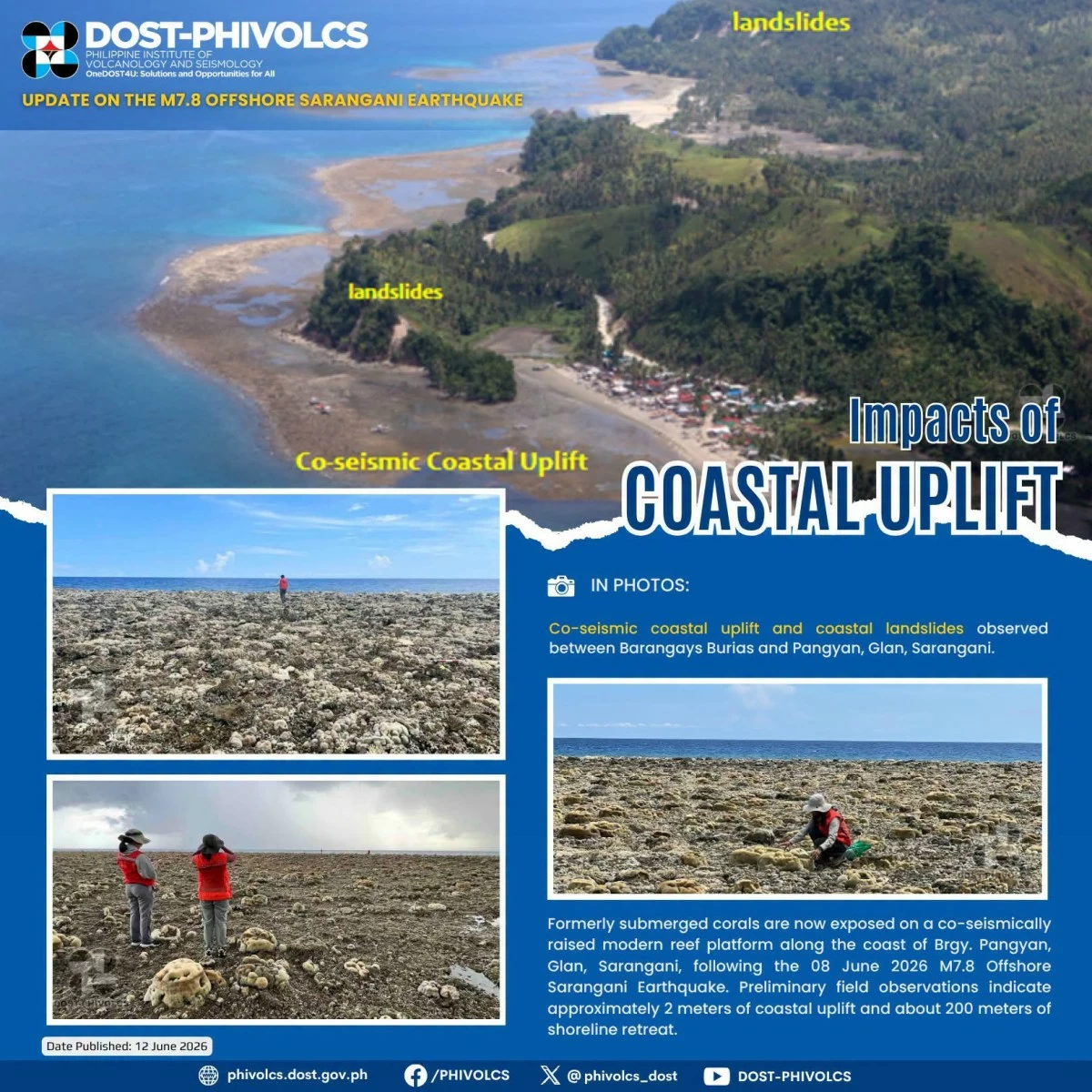
- Based on initial observations, Phivolcs said corals that were previously submerged underwater were found exposed above sea level, indicating that portions of the coastline had been uplifted by the powerful earthquake.
- Phivolcs also observed a significant retreat of the shoreline, with the coastline moving seaward by approximately 200 meters.
Philippine Institute of Volcanology and Seismology
Days after the magnitude 7.8 earthquake on June 8, field and aerial assessments are revealing the extent of the geological changes left behind across parts of southern Mindanao.
Surveys conducted by the Philippine Institute of Volcanology and Seismology (Phivolcs) and the Mines and Geosciences Bureau (MGB) Region XII on June 11 found evidence of coastal uplift, landslides, liquefaction and tsunami impacts in several affected communities.
The survey documented co-seismic coastal uplift and landslides in several areas of Glan, Sarangani, including its southern portion, as well as in Jose Abad Santos, Davao Occidental.
Based on initial observations, Phivolcs said corals that were previously submerged underwater were found exposed above sea level, indicating that portions of the coastline had been uplifted by the powerful earthquake.
In one of the affected areas, the shoreline of Barangay Pangyan in Glan, Phivolcs estimated that the coast rose by about two meters, it added.
Phivolcs also observed a significant retreat of the shoreline, with the coastline moving seaward by approximately 200 meters.
“The earthquake was caused by the movement of the Cotabato Trench, which pushed upward part[s] of the coastlines of Sarangani and Davao Occidental and consequently exposed the bottom of the sea that was originally submerged,” the agency explained.
The Cotabato Trench is an active fault capable of generating major tremors. Its movement also caused the 1976 Moro Gulf earthquake and tsunami, which killed an estimated 8,000 people.
Landslides, liquefaction, tsunami inundation
Phivolcs said a translational slide involving a backfilled concrete slope was also observed along the national highway in Barangay Tinoto, Maasim, Sarangani.
A topple-type landslide and rock falls were also documented along the roadside near AJM Beach Resort in Purok 7, Barangay Tinoto.
The assessments further noted widespread liquefaction in parts of Sarangani and General Santos City, where water-saturated soil lost strength during strong shaking.
In Barangay Sapu Masla, Malapatan, liquefaction triggered lateral spreading that severely damaged a river dike.
Similar ground deformation was observed in Agan Land Metro and Hikban Subdivision in Barangay Lagao, as well as residential areas in Barangay Bula in General Santos City, Phivolcs said.
Manifestations included sediment venting, ground swelling, differential settlement and surface cracking, it added.
Moreover, one of the immediate impacts of the destructive earthquake was a tsunami that reached several coastal communities within hours of the tremor.
In Purok Mauswagon, Barangay Sta. Clara, Kalamansig, Sultan Kudarat, Phivolcs said tsunami inundation reached about 163 meters inland with a run-up height of 1.8 meters.
A wave measuring 1.94 meters damaged a stilt house and washed boats ashore.
In Barangay Salaman, Lebak, Phivolcs said residents reported the sea receding before surging inland about four minutes later, a sequence that reportedly occurred three times.
The area recorded a maximum inundation distance of 18 meters and a run-up height of 2.5 meters.
Another inundation of about 16 meters inland, with a run-up height of up to 1.6 meters, was observed in Barangay Kinodalan, Lebak, the agency said.
As of 9 a.m. Sunday, June 14, Phivolcs said the earthquake has generated 5,200 aftershocks ranging from magnitude 1.2 to 6.4. Of these, 76 were felt.