


Manila Bulletin
 Philippines
National
Prolonged impacts possible if 'very strong' El Niño develops, PAGASA warns
Philippines
National
Prolonged impacts possible if 'very strong' El Niño develops, PAGASA warns
Philippines
National
Prolonged impacts possible if 'very strong' El Niño develops, PAGASA warns
Prolonged impacts possible if 'very strong' El Niño develops, PAGASA warns
Published Jun 1, 2026 01:09 pm


At A Glance
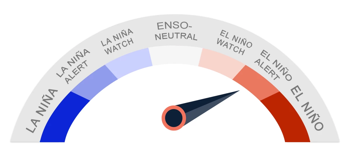
- The looming El Niño is initially expected to be weak before intensifying into a strong event by the September-October-November season, with increasing chances of reaching "very strong" levels by November-December-January.
As El Niño becomes more likely to develop between June and August, the Philippine Atmospheric, Geophysical and Astronomical Services Administration (PAGASA) warned that the Philippines may face extreme weather events in the coming months, with heavy rains early in the period before conditions gradually turn warmer and drier later in the year.
Most climate models suggest El Niño may emerge between June and August and may persist into early 2027, with increasing chances that it could become a “strong” to “very strong” event toward the end of 2026.
“Majority of climate models suggest that El Niño will emerge soon, with a 92 percent probability during the June-July-August season, and may persist until early 2027,” PAGASA weather specialist Joey Figuracion said at a climate forum.
He said the looming El Niño is initially expected to be weak before intensifying into a strong event by the September-October-November season, with increasing chances of reaching “very strong” levels by November-December-January.
“A stronger El Niño… means mas matagal tayo makakaranas or exposed tayo kasi vulnerable na tayo sa impact (A stronger El Niño means we are exposed for a longer time because we are already vulnerable to its impacts),” Figuracion said.
Moreover, he explained that despite the developing El Niño, the early phase of the climate phenomenon may still overlap with the southwest monsoon or “habagat” season from June to September.
The habagat can still bring moisture-laden winds from the west, which may result in episodes of heavy rainfall, which means flooding risks do not disappear during El Niño’s early stages, especially in low-lying and flood-prone areas.
“During the southwest monsoon ay enhanced ang habagat which can lead to heavy rainfall events over the western side of the country, especially sa western side ng Luzon and Visayas (During the southwest monsoon, the habagat is enhanced and can lead to heavy rainfall events over western Luzon and Visayas),” Figuracion said.
Fewer but more intense cyclones
PAGASA also said tropical cyclone activity may be slightly reduced during the latter part of 2026, with around nine to 13 systems expected to enter or form within the Philippine Area of Responsibility from June to November.
However, the weather bureau said that cyclone frequency is only one part of the overall risk.
“Kung mas konti ang tropical cyclones, hindi ibig sabihin ay mas safe na tayo (If there are fewer tropical cyclones, it does not mean we are safer),” Figuracion said.
He said that during El Niño conditions, some cyclones may form farther from the Philippines, allowing them to spend more time over warm ocean waters and intensify before entering the PAR.
He added that such weather systems can still reach typhoon or even super typhoon strength depending on the amount of energy they gain over warm seas.
Drier, warmer conditions
As El Niño strengthens, Figuracion said rainfall is expected to gradually decline.
He said changes in rainfall patterns may already be noticeable by October, with shifts in rain-bearing systems and rainfall distribution toward the eastern part of the country.
Figuracion said forecast data for October suggests below-normal rainfall across large parts of Luzon and the Visayas, while Mindanao may still experience near-normal conditions in some areas.
He added that probabilistic forecasts indicate a high confidence of below-normal rainfall across much of the country by October.
By November, he said, the outlook becomes more pronounced, with most parts of the country expected to experience reduced rainfall, particularly Luzon, where conditions may fall to well below normal levels.
PAGASA said dry spells may begin around November as the country moves into a drier phase.
“Dry and drought conditions are assessed based on consecutive months, and based on current forecasts, signs may already be seen prior to November,” Figuracion said.
He said prolonged dry spells or drought conditions are “highly likely” by early 2027, as El Niño is expected to persist until that period.
PAGASA also noted that if El Niño extends into 2027, warmer-than-normal conditions may be felt during the peak of the dry season.
“Because we expect El Niño to persist until early 2027, and the warm months of March, April, and May fall under the peak of the dry season, if El Niño coincides with these months, we may experience extreme heat during those periods,” Figuracion said.
READ MORE: