







'Domeng' on its way out, but enhanced habagat rains persist
Areas affected by recent rains should remain alert for possible flooding, landslides — PAGASA
Published May 31, 2026 09:42 am
|
Updated May 31, 2026 02:08 pm


At A Glance
- Metro Manila and several areas in Luzon and Visayas may experience moderate to heavy rainfall over the next four days due to the southwest monsoon (habagat) enhanced by Typhoon Domeng.
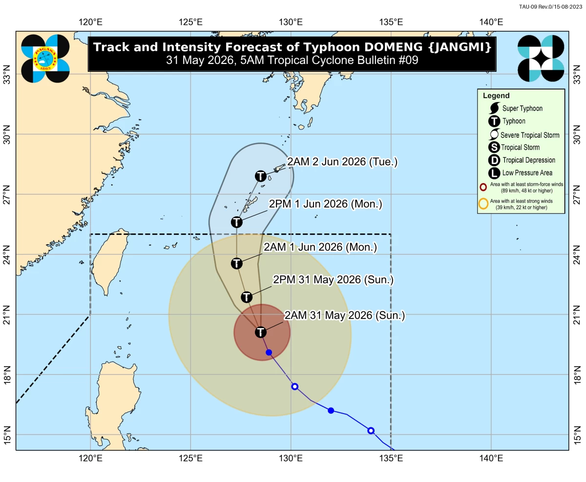
Track and intensity forecast for Typhoon Domeng (PAGASA)
Typhoon Domeng (international name: Jangmi) is expected to exit the Philippine Area of Responsibility (PAR) by June 1, but it will continue to enhance the southwest monsoon or “habagat,” bringing rains over western parts of the country over the next four days, the Philippine Atmospheric, Geophysical and Astronomical Services Administration (PAGASA) said Sunday, May 31.
As of 3 a.m., the center of the eye of Domeng was located 670 kilometers east of Basco, Batanes, packing maximum sustained winds of 120 kilometers per hour (kph) near the center and gustiness of up to 150 kph.
It was moving north-northwestward at 20 kph.
Despite its expected exit, PAGASA weather specialist Veronica Torres said the enhanced habagat will bring rains over several parts of western Philippines.
She advised areas affected by recent rains to remain alert for possible flooding and landslides.
On Sunday, the trough or extension of Domeng continued to bring scattered rains and thunderstorms over Central Luzon, Cagayan, and Isabela.
The southwest monsoon was also affecting Metro Manila, Calabarzon, Bicol Region, Mimaropa, Western Visayas, Negros Island Region, Zamboanga Peninsula, and the Bangsamoro Autonomous Region in Muslim Mindanao.
For June 1, Torres said the habagat will continue to bring rains over Metro Manila, Central Luzon, Calabarzon, Mimaropa, Bicol Region, Western Visayas, and Negros Island Region.
On June 2, scattered rains and thunderstorms are expected over Metro Manila, Central Luzon, Calabarzon, Mimaropa, Western Visayas, and Negros Island Region.
From June 3 to 4, the southwest monsoon will still bring rains but over fewer areas, including Metro Manila, Central Luzon, Calabarzon, and Mimaropa.
“Dahil mahaba yung range ng ating nabanggit, may tsansa itong magbago kaya patuloy pa rin tayong mag-antabay sa mga susunod na update ng PAGASA (Because the forecast covers a wide range of days, there is a chance this may still change, so we continue to monitor PAGASA updates),” Torres said.
PAGASA also warned of rough sea conditions over several coastal waters due to the enhanced southwest monsoon.
Seas may reach up to 3.5 meters along the seaboard of Batanes and the eastern seaboards of Babuyan Islands and mainland Cagayan.
Up to 3.0-meter waves are also expected along the seaboard of Isabela and the northern seaboard of Babuyan Islands.
Mariners of small seacraft, including motor bancas, were advised not to venture out to sea under these conditions, especially those who are inexperienced or operating ill-equipped vessels.
Moderate to rough seas ranging from 2.0 to 2.5 meters are also expected over the remaining seaboards of Cagayan, Aurora, Catanduanes, Camarines Norte, Camarines Sur, Northern Samar, Sorsogon, Eastern Samar, Dinagat Islands, and Davao Oriental, where small vessel operators were advised to take precautionary measures.