






Manila Bulletin
 Philippines
National
Storm trough, southwesterly wind flow drench parts of VisMin, Palawan
Philippines
National
Storm trough, southwesterly wind flow drench parts of VisMin, Palawan
Philippines
National
Storm trough, southwesterly wind flow drench parts of VisMin, Palawan
Storm trough, southwesterly wind flow drench parts of VisMin, Palawan
Published May 28, 2026 09:35 am
|
Updated May 28, 2026 01:30 pm


At A Glance
- The tropical storm with the international name "Jangmi" was located 1,195 kilometers east of Eastern Visayas as of 3 a.m.
- Once it enters PAR between Thursday evening and Friday morning, the cyclone will be given the local name "Domeng."
- PAGASA said the weather disturbance currently has a low chance of making landfall in the country but may enhance the southwesterly wind flow.
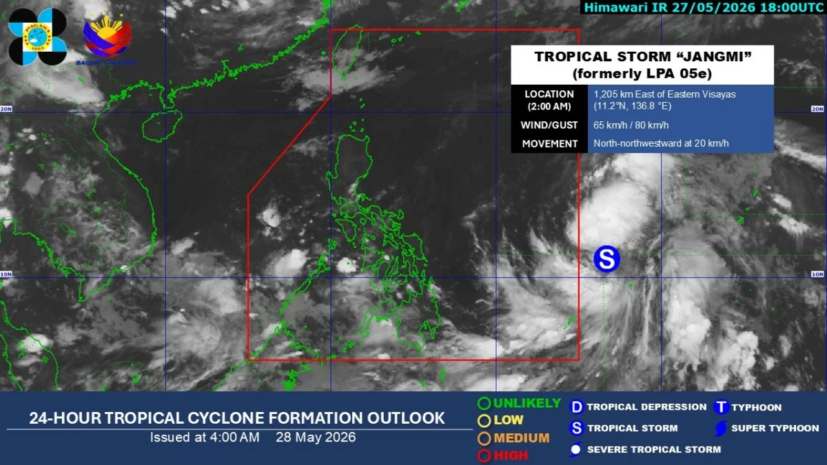
Satellite image (Courtesy of PAGASA)
The trough or extension of a tropical storm outside the Philippine area of responsibility (PAR) and the prevailing southwesterly wind flow continued to bring rains over large parts of the Visayas, Mindanao, and Palawan on Thursday, May 28, according to the Philippine Atmospheric, Geophysical and Astronomical Services Administration (PAGASA).
Over the next 24 hours, PAGASA said cloudy skies with scattered rains and thunderstorms may prevail over Western Visayas, Negros Island Region, Zamboanga Peninsula, Soccsksargen, Bangsamoro Autonomous Region in Muslim Mindanao, Lanao del Norte, Misamis Occidental, and Palawan due to the southwesterly wind flow.
The rest of Mindanao may also experience scattered rains and thunderstorms due to the trough of the tropical storm.
Meanwhile, Metro Manila and the rest of Luzon and Visayas will continue to experience partly cloudy to cloudy skies with chances of isolated rain showers or thunderstorms, mostly in the afternoon or evening.
PAGASA weather specialist Loriedin de la Cruz-Galicia said the tropical storm with the international name “Jangmi” was located 1,195 kilometers east of Eastern Visayas as of 3 a.m.
The weather disturbance was packing maximum sustained winds of 55 kilometers per hour (kph) near the center and gustiness of up to 80 kph while moving north-northwestward at 20 kph.
Once it enters PAR, the cyclone will be given the local name “Domeng.”
“Base na rin sa track na ipinalabas natin kagabi sa ating tropical cyclone advisory, mabagal ang pagkilos niya over the past few hours. At sa mga susunod na araw ay medyo may kabagalan pa dahil nagko-consolidate pa at lumalakas pa ito at lalo na’t malakas din ang high-pressure area na nakakahadlang sa kanya upang ito ay kumilos pa-northwestward (Based on the track we released last night in our tropical cyclone advisory, its movement has been slow over the past few hours. In the coming days, it may continue moving slowly as it is still consolidating and intensifying, especially with the strong high-pressure area preventing it from moving northwestward),” de la Cruz-Galicia said.
“Pero most likely ay papasok ito ng area of responsibility likely between tonight o bukas ng umaga. Posible pumasok ‘yan as tropical storm or severe tropical storm (But most likely it will enter the area of responsibility between tonight and tomorrow morning. It may enter as a tropical storm or severe tropical storm),” she added.
De la Cruz-Galicia said the cyclone may further intensify while inside the Philippine area of responsibility.
It could reach its peak intensity over the Philippine Sea and become a typhoon before exiting PAR by Monday, June 1, she said.
Despite the projected intensification, PAGASA said the weather disturbance currently has a low chance of making landfall in the country but may enhance the southwesterly wind flow.
“Dahil nakikita natin na mababa ang tsansa na mag-landfall ito sa anumang bahagi ng bansa, ang scenario nito ay ma-eenhance niya ‘yung southwesterly wind flow at ‘yung southwesterly wind flow ang magdudulot ng malawakang pag-ulan sa malaking bahagi ng Visayas, sa ilang bahagi ng Mindanao, pati sa Southern Luzon, lalong-lalo na starting by weekend hanggang early next week (Because we are seeing a low chance of landfall in any part of the country, the scenario is that it may enhance the southwesterly wind flow, which will bring widespread rains over large parts of the Visayas, some parts of Mindanao, and Southern Luzon, especially starting this weekend until early next week),” de la Cruz-Galicia said.
“Ngayon may mga ulan na dulot ng southwesterly wind flow pero inaasahan nating madadagdagan pa ang mga makakaranas ng mga pag-ulan lalong-lalo na by weekend hanggang early next week dahil sa enhanced southwesterly wind flow (There are already rains being experienced due to the southwesterly wind flow, but we expect more areas to experience rainfall, especially by the weekend until early next week because of the enhanced southwesterly wind flow),” she added.