






Manila Bulletin
 Philippines
National
No landfall threat, but tropical depression to stir 'habagat' rains, PAGASA warns
Philippines
National
No landfall threat, but tropical depression to stir 'habagat' rains, PAGASA warns
Philippines
National
No landfall threat, but tropical depression to stir 'habagat' rains, PAGASA warns
No landfall threat, but tropical depression to stir 'habagat' rains, PAGASA warns
Published May 27, 2026 08:47 am


At A Glance
- The tropical depression was estimated at 1,230 kilometers east of northeastern Mindanao as of 3 a.m.
- It could enter the PAR by Thursday or Friday, May 28 or 29, when it will be named "Domeng."
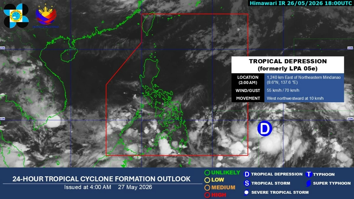
Satellite image of a tropical depression outside the Philippine area of responsibility (Courtesy of PAGASA)
Several parts of the country may experience widespread rains starting this weekend and possibly continuing into next week as a tropical depression east of Mindanao enhances the southwest monsoon or “habagat,” the Philippine Atmospheric, Geophysical and Astronomical Services Administration (PAGASA) warned on Wednesday, May 27.
PAGASA weather specialist Chenel Dominguez said the tropical depression was estimated at 1,230 kilometers east of northeastern Mindanao as of 3 a.m., with maximum sustained winds of 55 kilometers per hour (kph) near the center and gustiness of up to 70 kph.
It was moving west-northwestward at 10 kph.
Based on PAGASA’s forecast track, the tropical depression may intensify into a tropical storm while still outside PAR and could enter the country’s monitoring area by Thursday or Friday, May 28 or 29, when it will be named “Domeng.”
Dominguez said the weather disturbance may further intensify into a typhoon by Saturday, May 30.
“Ito po ay typhoon category, which is malakas na bagyo at meron na rin tayong prevalence ng southwesterly wind flow so inaasahan po natin ie-enhance or hihilain po ng bagyong ito ang southwest monsoon kung saan makakaranas po tayo ng mga pag-ulan starting weekend sa malaking bahagi ng bansa at posibleng magtutuloy hanggang sa susunod na linggo (This may reach typhoon category, which is already a strong cyclone, and with the prevailing southwesterly wind flow, we expect this system to enhance or pull the southwest monsoon, which may bring rains over large parts of the country starting this weekend and possibly continuing into next week),” she said.
Dominguez said the trough or extension of the tropical depression is already bringing moderate to heavy rains over eastern Mindanao.
She added that the southwesterly wind flow is bringing scattered rains and thunderstorms over Palawan and western Mindanao.
Meanwhile, generally fair weather conditions may continue over Luzon and the Visayas, although isolated afternoon or evening rain showers and thunderstorms remain possible.
Dominguez warned of possible flash floods and landslides in the coming days due to prolonged or heavy rainfall, especially in hazard-prone areas.