

ADVERTISEMENT

Tropical depression develops east of Mindanao, to be named 'Domeng' once inside PAR — PAGASA

Published May 26, 2026 04:29 pm

At A Glance

  • As of 4 p.m., the tropical depression was located 1,370 kilometers east of northeastern Mindanao, with maximum sustained winds of 45 kph near the center and gustiness of up to 55 kph.
  • Cloudy skies, scattered rains, and thunderstorms are expected over Palawan and Mindanao due to the combined effects of the southwesterly wind flow and trough or extension of the tropical depression.
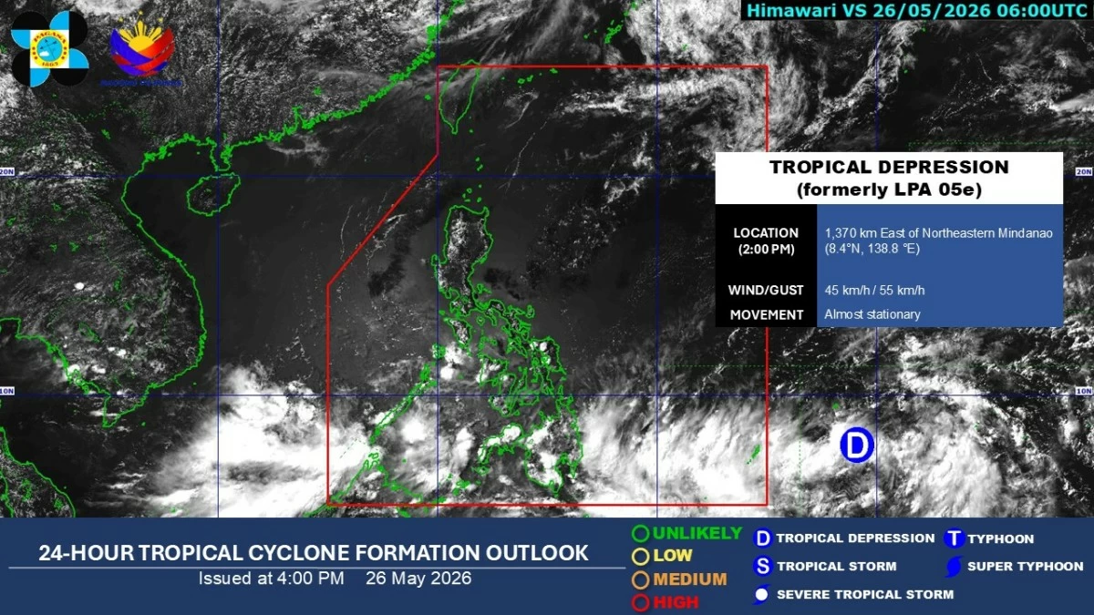
Satellite image (Courtesy of PAGASA)
The low-pressure area (LPA) outside the Philippine Area of Responsibility (PAR) has intensified into a tropical depression on Tuesday afternoon, May 26, said the Philippine Atmospheric, Geophysical and Astronomical Services Administration (PAGASA).
As of 4 p.m., the tropical depression was located 1,370 kilometers east of northeastern Mindanao, with maximum sustained winds of 45 kilometers per hour (kph) near the center and gustiness of up to 55 kph.
The weather system is almost stationary, according to PAGASA.
During PAGASA’s climate forum, weather specialist Daniel James Villamil said the weather system may enter PAR by Thursday or Friday, May 28 or 29.
It will be named “Domeng” once inside PAGASA’s monitoring area.
Over the next 24 hours, PAGASA said the trough or extension of the tropical depression, combined with the southwesterly wind flow, will continue to affect most of Mindanao and Palawan.
Cloudy skies with scattered rains and thunderstorms are expected over Zamboanga Peninsula, Bangsamoro Autonomous Region in Muslim Mindanao, Soccsksargen, Lanao del Norte, Misamis Occidental, and Palawan due to the southwesterly wind flow.
The trough of the tropical depression will bring similar conditions over the rest of Mindanao.
PAGASA warned that moderate to, at times, heavy rains may trigger flash floods or landslides, especially in areas that are highly or very highly susceptible to these hazards.
Meanwhile, Metro Manila and the rest of the country will experience partly cloudy to cloudy skies with isolated rainshowers or thunderstorms.
Villamil noted that the development of the tropical cyclone may help trigger the onset of the southwest monsoon or “habagat” season, which could bring persistent rainfall over Palawan, Visayas, and Mindanao in the coming days.
He added that the weather disturbance may move generally northward or northwestward, making landfall in the country unlikely.

Related Tags

PAGASA TROPICAL DEPRESSION DOMENG LPA HABAGAT SOUTHWEST MONSOON
ADVERTISEMENT
.most-popular .layout-ratio{ padding-bottom: 79.13%; } @media (min-width: 768px) and (max-width: 1024px) { .widget-title { font-size: 15px !important; } }

{{ articles_filter_1561_widget.title }}

.most-popular .layout-ratio{ padding-bottom: 79.13%; } @media (min-width: 768px) and (max-width: 1024px) { .widget-title { font-size: 15px !important; } }

{{ articles_filter_1562_widget.title }}

.most-popular .layout-ratio{ padding-bottom: 79.13%; } @media (min-width: 768px) and (max-width: 1024px) { .widget-title { font-size: 15px !important; } }

{{ articles_filter_1563_widget.title }}

{{ articles_filter_1564_widget.title }}

.mb-article-details { position: relative; } .mb-article-details .article-body-preview, .mb-article-details .article-body-summary{ font-size: 17px; line-height: 30px; font-family: "Libre Caslon Text", serif; color: #000; } .mb-article-details .article-body-preview iframe , .mb-article-details .article-body-summary iframe{ width: 100%; margin: auto; } .read-more-background { background: linear-gradient(180deg, color(display-p3 1.000 1.000 1.000 / 0) 13.75%, color(display-p3 1.000 1.000 1.000 / 0.8) 30.79%, color(display-p3 1.000 1.000 1.000) 72.5%); position: absolute; height: 200px; width: 100%; bottom: 0; display: flex; justify-content: center; align-items: center; padding: 0; } .read-more-background a{ color: #000; } .read-more-btn { padding: 17px 45px; font-family: Inter; font-weight: 700; font-size: 18px; line-height: 16px; text-align: center; vertical-align: middle; border: 1px solid black; background-color: white; } .hidden { display: none; }
function initializeAllSwipers() { // Get all hidden inputs with cms_article_id document.querySelectorAll('[id^="cms_article_id_"]').forEach(function (input) { const cmsArticleId = input.value; const articleSelector = '#article-' + cmsArticleId + ' .body_images'; const swiperElement = document.querySelector(articleSelector); if (swiperElement && !swiperElement.classList.contains('swiper-initialized')) { new Swiper(articleSelector, { loop: true, pagination: false, navigation: { nextEl: '#article-' + cmsArticleId + ' .swiper-button-next', prevEl: '#article-' + cmsArticleId + ' .swiper-button-prev', }, }); } }); } setTimeout(initializeAllSwipers, 3000); const intersectionObserver = new IntersectionObserver( (entries) => { entries.forEach((entry) => { if (entry.isIntersecting) { const newUrl = entry.target.getAttribute("data-url"); if (newUrl) { history.pushState(null, null, newUrl); let article = entry.target; // Extract metadata const author = article.querySelector('.author-section').textContent.replace('By', '').trim(); const section = article.querySelector('.section-info ').textContent.replace(' ', ' '); const title = article.querySelector('.article-title h1').textContent; // Parse URL for Chartbeat path format const parsedUrl = new URL(newUrl, window.location.origin); const cleanUrl = parsedUrl.host + parsedUrl.pathname; // Update Chartbeat configuration if (typeof window._sf_async_config !== 'undefined') { window._sf_async_config.path = cleanUrl; window._sf_async_config.sections = section; window._sf_async_config.authors = author; } // Track virtual page view with Chartbeat if (typeof pSUPERFLY !== 'undefined' && typeof pSUPERFLY.virtualPage === 'function') { try { pSUPERFLY.virtualPage({ path: cleanUrl, title: title, sections: section, authors: author }); } catch (error) { console.error('ping error', error); } } // Optional: Update document title if (title && title !== document.title) { document.title = title; } } } }); }, { threshold: 0.1 } ); function showArticleBody(button) { const article = button.closest("article"); const summary = article.querySelector(".article-body-summary"); const body = article.querySelector(".article-body-preview"); const readMoreSection = article.querySelector(".read-more-background"); // Hide summary and read-more section summary.style.display = "none"; readMoreSection.style.display = "none"; // Show the full article body body.classList.remove("hidden"); } document.addEventListener("DOMContentLoaded", () => { let loadCount = 0; // Track how many times articles are loaded const offset = [1, 2, 3, 4, 5, 6, 7, 8, 9, 10]; // Offset values const currentUrl = window.location.pathname.substring(1); let isLoading = false; // Prevent multiple calls if (!currentUrl) { console.log("Current URL is invalid."); return; } const sentinel = document.getElementById("load-more-sentinel"); if (!sentinel) { console.log("Sentinel element not found."); return; } function isSentinelVisible() { const rect = sentinel.getBoundingClientRect(); return ( rect.top < window.innerHeight && rect.bottom >= 0 ); } function onScroll() { if (isLoading) return; if (isSentinelVisible()) { if (loadCount >= offset.length) { console.log("Maximum load attempts reached."); window.removeEventListener("scroll", onScroll); return; } isLoading = true; const currentOffset = offset[loadCount]; window.loadMoreItems().then(() => { let article = document.querySelector('#widget_1690 > div:nth-last-of-type(2) article'); intersectionObserver.observe(article) loadCount++; }).catch(error => { console.error("Error loading more items:", error); }).finally(() => { isLoading = false; }); } } window.addEventListener("scroll", onScroll); });

Sign up by email to receive news.