


Manila Bulletin
 Philippines
National
LPA may develop into tropical depression within 24 hours, enter PAR late this week — PAGASA
Philippines
National
LPA may develop into tropical depression within 24 hours, enter PAR late this week — PAGASA
Philippines
National
LPA may develop into tropical depression within 24 hours, enter PAR late this week — PAGASA
LPA may develop into tropical depression within 24 hours, enter PAR late this week — PAGASA
Published May 26, 2026 11:45 am
|
Updated May 26, 2026 01:51 pm


At A Glance
- The potential development of the LPA into a tropical cyclone may help trigger the onset of the southwest monsoon (habagat), which could lead to more persistent rainfall over Palawan, Visayas, and Mindanao in the coming days.
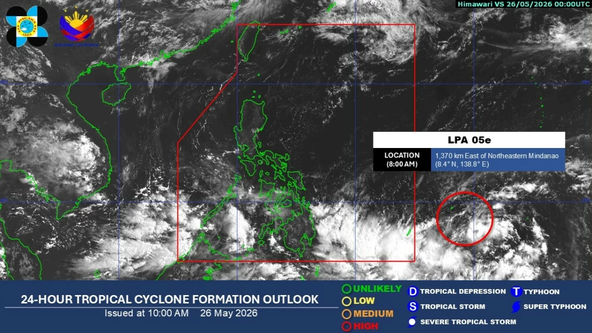
Satellite image (Courtesy of PAGASA)
A low-pressure area (LPA) located outside the Philippine Area of Responsibility (PAR) is highly likely to develop into a tropical depression within the day, according to the Philippine Atmospheric, Geophysical and Astronomical Services Administration (PAGASA).
As of 8 a.m. Tuesday, May 26, the LPA was estimated at about 1,370 kilometers east of northeastern Mindanao.
During PAGASA’s climate forum, weather specialist Daniel James Villamil said the weather system may enter PAR by Thursday or Friday, May 28 or 29. It will be named “Domeng” once it enters PAR as a tropical cyclone.
Villamil said the weather disturbance is expected to move generally northward or northwestward in the coming days, although the track may still change depending on how it develops.
“Sa ating latest satellite images, makikita natin itong trough or extension ay nakakaapekto over the southern portion ng Pilipinas. Magdudulot ito ng pag-ulan sa northern and eastern portions of Mindanao (In the latest satellite images, we can see that the trough or extension is affecting the southern portion of the Philippines. This will bring rains over the northern and eastern portions of Mindanao),” he said.
He added that the southwesterly wind flow, or the initial surge of the southwest monsoon or “habagat,” may also affect Palawan and western sections of Mindanao, particularly Zamboanga Peninsula, Bangsamoro Autonomous Region in Muslim Mindanao (BARMM), and Soccsksargen.
Metro Manila and the rest of the country will generally experience fair weather conditions, with partly cloudy to cloudy skies and isolated rain showers or thunderstorms in the afternoon or evening, he said.
Villamil also noted that the potential development of the LPA into a tropical cyclone may help trigger the onset of the southwest monsoon, which could lead to more persistent rainfall over Palawan, Visayas, and Mindanao in the coming days.
READ MORE:
Five-day outlook
While a landfall scenario remains unlikely, the brewing tropical cyclone may draw in cloudiness from the southwest, which could enhance rainfall over parts of the country.
Villamil said the southwesterly wind flow will continue to affect Palawan and the western portions of the Visayas and Mindanao until the weekend, with moderate to rough seas expected toward the end of the week over the eastern sections of the country due to the potential tropical cyclone.
From May 26 to 27, scattered rains and thunderstorms are expected over Mindanao and Palawan due to the combined effects of the trough of the LPA and the southwesterly wind flow.
From May 28 to 30, scattered rains and thunderstorms may persist over Zamboanga Peninsula, BARMM, Soccsksargen, Western Visayas, Negros Island Region, and Palawan.