


Manila Bulletin
 Philippines
National
Low-pressure area inside PAR remains unlikely to redevelop into storm — PAGASA
Philippines
National
Low-pressure area inside PAR remains unlikely to redevelop into storm — PAGASA
Philippines
National
Low-pressure area inside PAR remains unlikely to redevelop into storm — PAGASA
Low-pressure area inside PAR remains unlikely to redevelop into storm — PAGASA
By Jel Santos
Published May 16, 2026 09:32 am
|
Updated May 16, 2026 01:33 pm


At A Glance
- PAGASA weather specialist Loriedin Dela Cruz-Galicia said the LPA, formerly Tropical Storm "Caloy," was last spotted 980 kilometers east of Central Luzon.
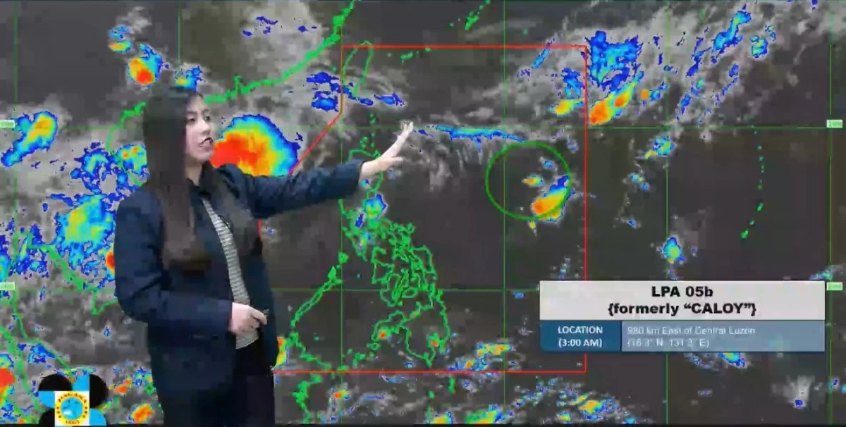
(Courtesy: DOST-PAGASA)
The low-pressure area (LPA) being monitored inside the Philippine Area of Responsibility (PAR) remains unlikely to redevelop into a tropical cyclone and continues to have no direct effect on any part of the country, the Philippine Atmospheric, Geophysical and Astronomical Services Administration said on Saturday, May 16.
PAGASA weather specialist Loriedin Dela Cruz-Galicia said the LPA, formerly Tropical Storm “Caloy,” was last spotted 980 kilometers east of Central Luzon.
“Huling namataan ang low-pressure area sa loob ng ating PAR sa layong 980 kilometers silangan ng Central Luzon at kasalukuyang napakababa pa rin ng tiyansa na mabuo ulit ito bilang isang bagyo (The low-pressure area inside our PAR was last spotted 980 kilometers east of Central Luzon and the chance of it redeveloping into a tropical cyclone remains very low),” she said in a weather briefing.
“Ito po ay si formerly Caloy na naging LPA na lamang—for the past few days ay LPA po siya. At dito po siya nag-sta-stay sa Philippine Sea (This is formerly Caloy which has weakened into an LPA—for the past few days it has remained an LPA and has been staying over the Philippine Sea),” she added.
PAGASA said the weather disturbance has remained almost stationary over the Philippine Sea in recent days.
“Hindi siya halos gumagalaw (It is barely moving),” Dela Cruz-Galicia said.
“At sa ngayon ay wala po itong direktang epekto sa anumang bahagi ng ating kalupaan (At present, it has no direct effect on any part of our landmass),” she went on.
Meanwhile, the state weather bureau said a frontal system continues to affect Extreme Northern Luzon, bringing cloudy skies with scattered rains and thunderstorms over Batanes and the Babuyan Islands.
“Samantala, frontal system naman ang nakakaapekto rito sa extreme Northern Luzon at nagdudulot po iyan ng maulap na papawirin at mga kalat-kalat na pag-ulan at pagkidlat, pagkulog sa Batanes at maging sa Babuyan Islands (Meanwhile, the frontal system affecting Extreme Northern Luzon is bringing cloudy skies with scattered rains, lightning, and thunder over Batanes and the Babuyan Islands),” Dela Cruz-Galicia said.
The frontal system and the LPA, according to PAGASA, are currently the two prevailing weather systems being monitored within the country’s area of responsibility.
“So far, dalawa pong weather systems ang prevailing o nandito po sa loob ng ating area of responsibility. Nakakaapekto po ‘yung frontal system sa extreme Northern Luzon habang ‘yung LPA ay nanatiling wala pong epekto saan mang bahagi ng ating kalupaan (So far, there are two prevailing weather systems within our area of responsibility. The frontal system is affecting Extreme Northern Luzon while the LPA continues to have no effect on any part of the country),” she said.