


Manila Bulletin
 Philippines
National
Tropical storm to enter PAR this weekend, to be named 'Caloy' — PAGASA
Philippines
National
Tropical storm to enter PAR this weekend, to be named 'Caloy' — PAGASA
Philippines
National
Tropical storm to enter PAR this weekend, to be named 'Caloy' — PAGASA
Tropical storm to enter PAR this weekend, to be named 'Caloy' — PAGASA
Published May 7, 2026 07:31 am


At A Glance
- As of 3 a.m. on Thursday, Hagupit was located about 1,995 kilometers east of northeastern Mindanao.
- It is expected to generally move west-northwestward and may enter the PAR between Saturday evening, May 9, and early Sunday morning, May 10.
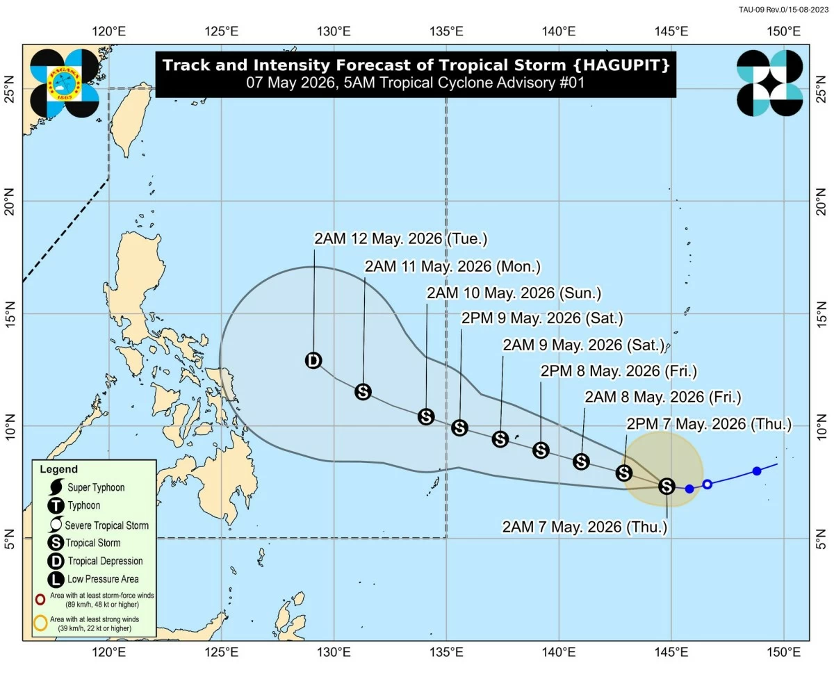
Track and intensity forecast for Tropical Storm Hagupit (PAGASA)
The tropical storm spotted east of the country is expected to enter the Philippine Area of Responsibility (PAR) this weekend and will be named “Caloy,” the Philippine Atmospheric, Geophysical and Astronomical Services Administration (PAGASA) said on Thursday, May 7.
PAGASA weather specialist Loriedin de la Cruz-Galicia said the weather system was given the international name “Hagupit” after strengthening from a tropical depression into tropical storm on Wednesday, May 6.
As of 3 a.m. on Thursday, Hagupit was located about 1,995 kilometers east of northeastern Mindanao.
It was moving westward at 20 kilometers per hour (kph), with maximum sustained winds of 65 kph near the center and gustiness of up to 80 kph.
De la Cruz-Galicia said the tropical storm is expected to generally move west-northwestward and may enter the PAR between Saturday evening, May 9, and early Sunday morning, May 10.
Once inside the PAR, it will be locally named Caloy, the country’s third tropical cyclone this year.
She said the storm may directly affect the eastern sections of Southern Luzon and Visayas “early next week,” bringing possible rains and gusty winds.
Based on long-range forecast, she said the tropical storm is expected to follow a weakening trend as it approaches landmass.
However, De la Cruz-Galicia said uncertainties remain due to its distance from the country, and advised the public to continue monitoring official updates.
Meanwhile, the low-pressure area (LPA) inside the PAR continues to bring rains over parts of the country.
As of 3 a.m., the LPA was located about 120 kilometers southeast of Hinatuan, Surigao del Sur.
De la Cruz-Galicia said it still has a low chance of developing into a tropical cyclone, but will continue to bring widespread rainfall.
Over the next 24 hours, scattered rains and thunderstorms are expected over Central Visayas, Eastern Visayas, Negros Island Region, Caraga, Northern Mindanao, Davao Region, and Zamboanga Peninsula.
PAGASA warned that moderate to at times heavy rains may trigger flash floods or landslides, especially in low-lying and mountainous areas.
The rest of the country will continued to be affected by easterlies, or warm winds from the Pacific Ocean, bringing generally hot and humid weather conditions with chances of isolated rain showers or thunderstorms in the afternoon or evening.