


Manila Bulletin
 Philippines
National
LPA enters PAR; another weather system becomes tropical depression
Philippines
National
LPA enters PAR; another weather system becomes tropical depression
Philippines
National
LPA enters PAR; another weather system becomes tropical depression
LPA enters PAR; another weather system becomes tropical depression
Published May 5, 2026 06:15 pm


At A Glance
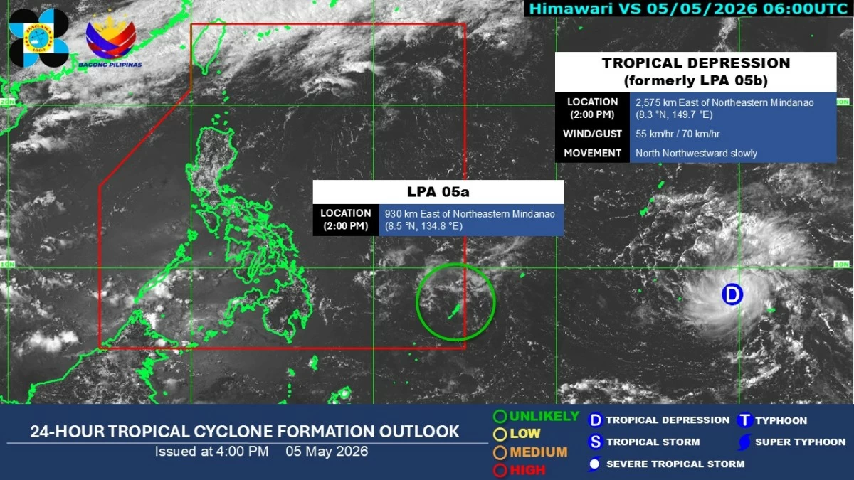
- LPA 05a has entered the PAR and was located 910 kilometers east of northeastern Mindanao as of 3 p.m. Meanwhile, the weather disturbance, formerly called LPA 05b, outside PAR has intensified into a tropical depression.
Satellite image (Courtesy of PAGASA)
One of the low-pressure areas (LPAs) being monitored by the Philippine Atmospheric, Geophysical and Astronomical Services Administration (PAGASA) has entered the Philippine Area of Responsibility (PAR), while the other has intensified into a tropical depression on Tuesday afternoon, May 5.
PAGASA weather specialist Benison Estareja said LPA 05a has entered the PAR and was located 910 kilometers east of northeastern Mindanao as of 3 p.m.
He said the LPA remains unlikely to develop into a tropical depression as it moves closer to the country.
However, its trough or outer circulation may begin affecting Eastern Visayas, Caraga, and Davao Region by Wednesday evening, May 6.
From Thursday to Saturday, May 7 to 9, the LPA is forecast to traverse Mindanao and southern Palawan.
Estareja said there is a chance it may dissipate while crossing Palawan, although rainfall may persist over parts of Palawan, the Visayas, and Mindanao for three to four days.
Meanwhile, the weather disturbance, formerly called LPA 05b, outside PAR has intensified into a tropical depression.
As of 3 p.m., it was located 2,560 kilometers east of northeastern Mindanao, with maximum sustained winds of 55 kilometers per hour near the center and gustiness of up to 70 kph. It was moving slowly north-northwestward.
Estareja said the tropical depression is expected to gradually move closer to the country while tracking westward or west-northwestward, crossing the southern Mariana Islands and the western Pacific Ocean before potentially entering PAR by Saturday, May 9, or Sunday, May 10.
Once inside PAR, it will be named “Caloy,” the third tropical cyclone of 2026.
He said one possible scenario is that the system may slightly approach Northern Luzon upon entering the northern Philippine Sea before veering away from land and gradually weakening.
Howver, Estareja said the forecast remains subject to change, depending on the weather systems’ movement and development.
For the next 24 hours, easterlies or warm winds from the Pacific Ocean will continue to affect the country, bringing generally warm and humid conditions with no widespread rainfall expected in most areas.