


Manila Bulletin
 Philippines
National
1 of 2 LPAs outside PAR may develop into tropical depression within 24 hours — PAGASA
Philippines
National
1 of 2 LPAs outside PAR may develop into tropical depression within 24 hours — PAGASA
Philippines
National
1 of 2 LPAs outside PAR may develop into tropical depression within 24 hours — PAGASA
1 of 2 LPAs outside PAR may develop into tropical depression within 24 hours — PAGASA
Published May 4, 2026 02:41 pm


At A Glance
- PAGASA said both weather disturbances currently have no direct effect on the country.
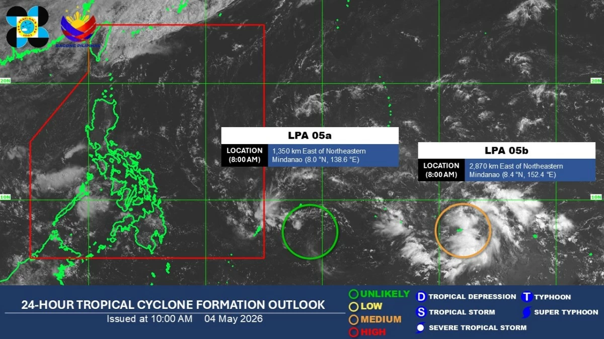
Satellite image (Courtesy of PAGASA)
One of two low pressure areas (LPAs) spotted outside the Philippine Area of Responsibility (PAR) has a medium chance of developing into a tropical depression within 24 hours, while the other is unlikely to intensify, the state weather bureau said on Monday, May 4.
The Philippine Atmospheric, Geophysical and Astronomical Services Administration (PAGASA) said LPA 05a is unlikely to develop into a tropical depression.
As of 8 a.m., it was located 1,350 kilometers east of northeastern Mindanao.
Meanwhile, LPA 05b has a medium potential of becoming a tropical depression.
It was last seen 2,870 kilometers east of northeastern Mindanao.
PAGASA said both systems currently have no direct effect on the country.
The easterlies will continue to affect weather conditions nationwide over the next 24 hours.
Western Visayas, Negros Island Region, Zamboanga Peninsula, Bangsamoro Autonomous Region in Muslim Mindanao, and Palawan will have cloudy skies with scattered rains and thunderstorms, with possible flash floods or landslides due to moderate to heavy rains.
Metro Manila and the rest of the country will experience generally fair weather, with isolated rain showers or thunderstorms in the afternoon or evening.