


Manila Bulletin
 Philippines
National
Metro Manila nitrogen dioxide falls below pre–Navotas landfill fire levels — PhilSA
Philippines
National
Metro Manila nitrogen dioxide falls below pre–Navotas landfill fire levels — PhilSA
Philippines
National
Metro Manila nitrogen dioxide falls below pre–Navotas landfill fire levels — PhilSA
Metro Manila nitrogen dioxide falls below pre–Navotas landfill fire levels — PhilSA
Published Apr 29, 2026 07:34 pm


At A Glance
- The latest data coincided with reports on Tuesday, April 28, that "significant progress" has been made in suppressing the fire
- Nitrogen dioxide is a pollutant produced from burning and is a component of smoke
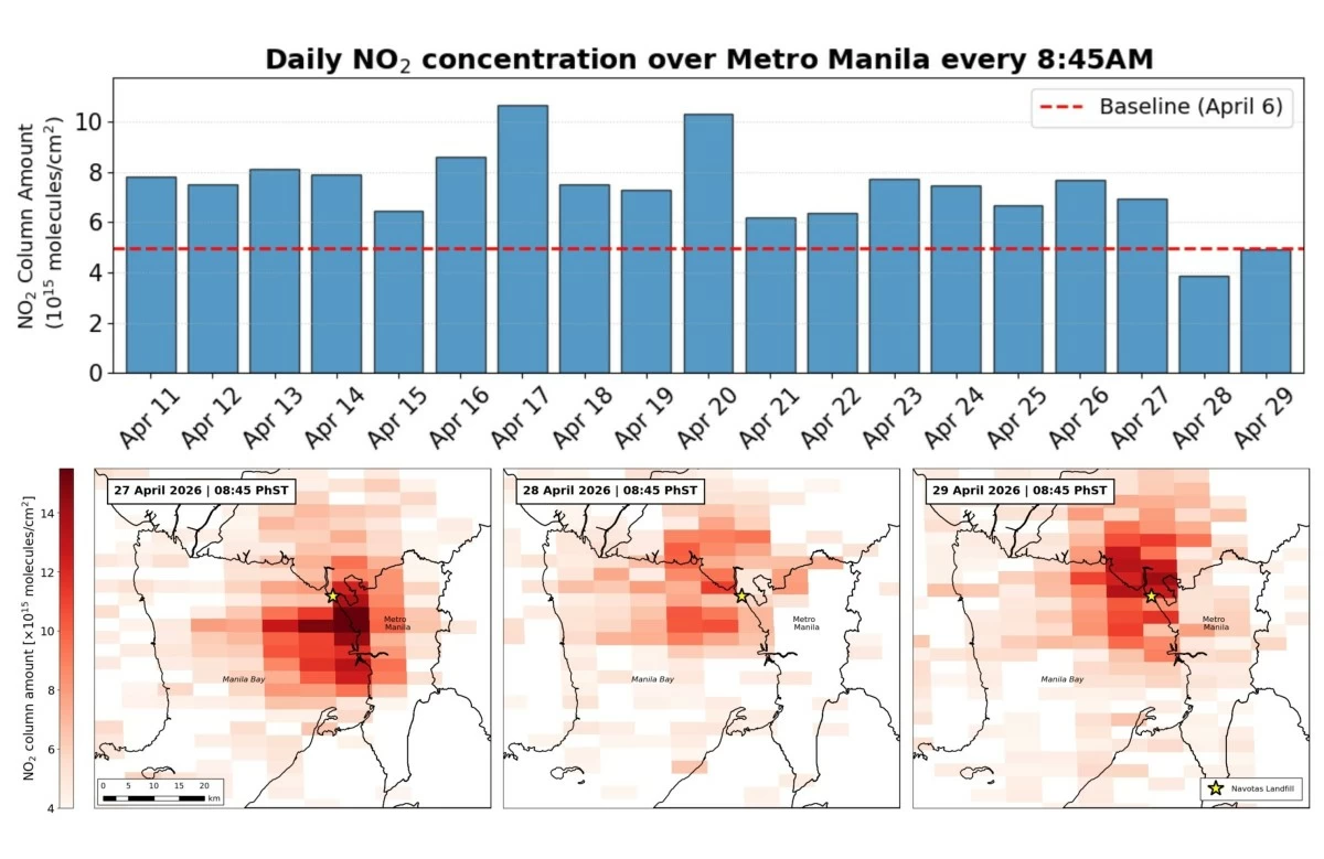
Daily nitrogen dioxide concentration over Metro Manila (Philippine Space Agency)
Satellite data from the Philippine Space Agency (PhilSA) shows that nitrogen dioxide (NO₂) levels over Metro Manila have fallen below pre-fire readings for two consecutive days.
PhilSA said in a statement on Wednesday, April 29, that the latest data coincided with reports on Tuesday, April 28, that “significant progress” has been made in suppressing the fire.
READ MORE:
It has been conducting monitoring since the Navotas landfill fire reportedly broke out on April 10.
Nitrogen dioxide is a pollutant produced from burning and is a component of smoke. It may also come from multiple sources, including vehicle emissions and power plants.
“Lower NO₂ concentrations indicate a reduction in the volume of smoke emitted from the landfill fire,” PhilSA said.
Ground measurements conducted by the Department of Environment and Natural Resources–Environmental Management Bureau (DENR-EMB) support the findings, with particulate matter (PM) over Metro Manila showing improvement on April 28 and 29.
“PhilSA will continue monitoring NO₂ to assist in quantifying the impact of ground interventions,” the agency said.
It also advised the public to follow local and national health agencies for the latest advisories.
Beyond air quality, PhilSA has also been tracking the estimated burned area at the Navotas landfill using near-infrared imagery from Sentinel-2C satellite data.
This method is commonly used to map burned areas characterized by ash, charcoal, and reduced vegetation.
Based on a satellite image captured on April 26 at 10:16 a.m., the estimated burned area reached 31.95 hectares or about 319,500 square meters.
“Comparing with the burnt area estimate from 16 April, there was an estimated 0.89 hectares decrease in burnt area in the southern part of the landfill while an increase of around 3.10 hectares was detected in the eastern part,” PhilSA said.
It clarified that the analysis is based on the April 26 image and “does not reflect the current state in the area.”
It also stressed that satellite data identifies burned areas only and “does not identify actively burning areas.”
PhilSA said its satellite monitoring provides wide-area coverage that helps authorities track the situation and prioritize response efforts.
It added that making space-based data accessible to stakeholders supports informed decision-making and strengthens disaster response.