


Manila Bulletin
 Philippines
National
'Larger than Quezon Memorial Circle': 28.6 hectares of Navotas landfill burned — PhilSA
Philippines
National
'Larger than Quezon Memorial Circle': 28.6 hectares of Navotas landfill burned — PhilSA
Philippines
National
'Larger than Quezon Memorial Circle': 28.6 hectares of Navotas landfill burned — PhilSA
'Larger than Quezon Memorial Circle': 28.6 hectares of Navotas landfill burned — PhilSA
Published Apr 21, 2026 12:50 pm
|
Updated Apr 21, 2026 02:19 pm


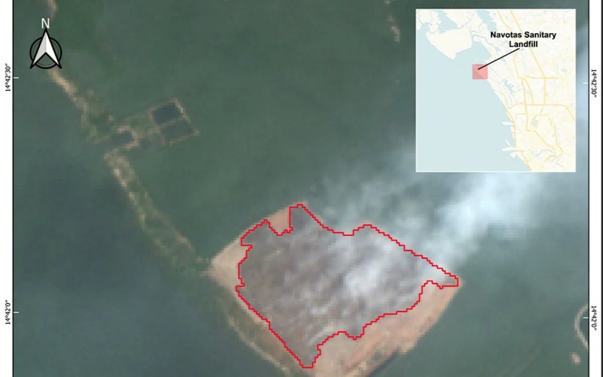
A satellite image shows the extent of the burned area at the Navotas Sanitary Landfill, where about 28.58 hectares were scorched following a fire that broke out on April 10, 2026, according to the Philippine Space Agency (PhilSA).
A satellite map released by the Philippine Space Agency (PhilSA) on Tuesday, April 21, showed the extent of the fire that has been burning at the Navotas Sanitary Landfill, indicating that much of the site has already been burned.
Based on satellite data captured on Thursday, April 16 at 10:33 a.m.—about six days after the fire reportedly started on April 10—PhilSA estimated that around 28.58 hectares, or roughly 285,800 square meters, of the landfill had already been burned.
“For comparison, this area is slightly larger than the Quezon Memorial Circle,” it said.
With a total area of about 41 hectares, nearly 70 percent of the Navotas Sanitary Landfill has been burned.
PhilSA said the map was generated using the near-infrared band of a Sentinel-2C satellite image, which helps distinguish burned areas from surrounding vegetation and built-up surfaces.
“PhilSA’s support through images and maps provides wide-area coverage that guides NDRRMC (National Disaster Risk Reduction and Management Council) in monitoring the situation and prioritizing areas for response,” it added.
Meanwhile, the agency stressed that satellite-based assessments still require field validation.
Since the fire, lingering haze has affected parts of Metro Manila, Central Luzon, and Calabarzon.
A separate map released by PhilSA on April 17 showed how smoke spread in the aftermath of the fire.
The time-lapse imagery presented hourly satellite observations from 7:45 a.m. to 3:45 p.m. on April 11, using nitrogen dioxide levels as a proxy for smoke presence during daytime monitoring, with darker shading indicating higher concentrations.
“On the morning of April 11, high nitrogen dioxide (NO₂) was observed over Navotas City, with elevated levels extending as far as Bataan due to predominantly westward wind from Navotas,” it said.
“By the afternoon of April 11, NO₂ concentrations had decreased, following its usual daytime behavior (due to the dissolution of the temperature inversion layer), but remained relatively high across Metro Manila,” it added.
PhilSA said the observations were consistent with reports of air quality impacts extending beyond the immediate vicinity of the landfill fire.
READ MORE: