


Manila Bulletin
 Philippines
National
Shear line to bring rains over Southern Luzon, parts of Visayas; 'amihan' affects rest of Luzon — PAGASA
Philippines
National
Shear line to bring rains over Southern Luzon, parts of Visayas; 'amihan' affects rest of Luzon — PAGASA
Philippines
National
Shear line to bring rains over Southern Luzon, parts of Visayas; 'amihan' affects rest of Luzon — PAGASA
Shear line to bring rains over Southern Luzon, parts of Visayas; 'amihan' affects rest of Luzon — PAGASA
No tropical cyclone or low-pressure area monitored inside PAR as of February 8
Published Feb 8, 2026 08:03 am


A shear line affecting Southern Luzon and the northeast monsoon (amihan) influencing the rest of Luzon will bring cloudy skies and scattered rains over large parts of the country on Sunday, February 8, according to the Philippine Atmospheric, Geophysical and Astronomical Services Administration (PAGASA).
In its latest public weather forecast, PAGASA weather specialist Veronica Torres said satellite images show a band of clouds within the Philippine Area of Responsibility (PAR) caused by a shear line.
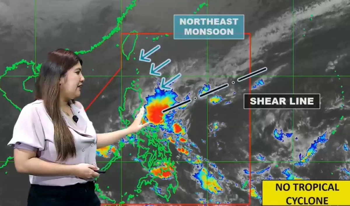
PAGASA warns of moderate to heavy rains over Southern Luzon and parts of the Visayas due to a shear line, while the northeast monsoon continues to affect the rest of Luzon on February 8, 2026. (PAGASA)
“Narito ang ating pinaka-latest na satellite image kung saan nakikita natin yung linya ng kaulapan sa loob ng ating Philippine Area of Responsibility — ito ang tinatawag nating shear line o yung salubunguan ng malamig na hangin galing northeast at mainit na hangin galing silangan (Here is our latest satellite image showing the cloud line within the Philippine Area of Responsibility — this is what we call the shear line, or the meeting point of cold air from the northeast and warm air from the east),” Torres said.
The shear line may bring periods of moderate to heavy rainfall over Southern Luzon and some areas of the Visayas today, she added.
“Nakikita natin na itong shear line ay posibleng magdala ng mga pag-ulan mostly sa areas ng Southern Luzon at ilang bahagi ng Visayas ngayong araw (We can see that this shear line may bring rainfall mostly over areas in Southern Luzon and some parts of the Visayas today),” Torres explained.
“Northeast monsoon o amihan ay makakaapekto sa Northern Luzon at magdadala rin ng mga pag-ulan sa ilang bahagi ng Kanlurang Luzon (The northeast monsoon, or amihan, will affect Northern Luzon and also bring rain to some parts of Western Luzon),” she added.
Areas affected by shear line
PAGASA said the shear line will cause cloudy skies with scattered rains and isolated thunderstorms over the following areas: Mimaropa, Bicol Region, Western Visayas, Aurora, Rizal, Laguna, Quezon, Northern Samar, and Eastern Samar.
Residents in these areas are advised to remain alert for possible flash floods and landslides, especially in low-lying and mountainous locations, due to moderate to heavy rains.
‘Amihan’ brings rain to Luzon
Meanwhile, PAGASA said the northeast monsoon continues to affect Northern and Central Luzon, bringing cloudy skies with rains over Metro Manila, Cagayan Valley, the Cordillera Administrative Region, Nueva Ecija, Bulacan, and the remaining areas of Calabarzon.
PAGASA warned that moderate to, at times, heavy rainfall in these areas may also trigger localized flooding or landslides.
The rest of Luzon may experience partly cloudy to cloudy skies with isolated light rains due to the “amihan,” with no significant weather impacts expected, PAGASA said.
For the rest of the country, PAGASA said partly cloudy to cloudy skies with isolated rainshowers or thunderstorms caused by localized thunderstorms are expected.
Severe thunderstorms may still result in flash floods or landslides in vulnerable areas, the state weather bureau added.
No LPA or storm inside PAR
PAGASA emphasized that no low-pressure area or tropical cyclone is currently being monitored inside the PAR.
“Sa kasalukuyan naman, wala tayong namo-monitor na Low Pressure Area o bagyo sa loob ng PAR (At present, we are not monitoring any Low Pressure Area or tropical cyclone inside the PAR),” Torres said.
PAGASA advised the public, particularly those in rain-affected regions, to stay updated with the latest weather advisories and take necessary precautions.