ADVERTISEMENT

TS Ada slightly weakens as it moves east-northeast of Catanduanes — PAGASA

Published Jan 18, 2026 10:55 am  |  Updated Jan 18, 2026 01:21 pm
Tropical Storm Ada slightly weakens as it moves east-northeast of Catanduanes, but continues to bring strong winds, heavy rain, and hazardous seas over parts of Luzon and the Visayas. (PAGASA)
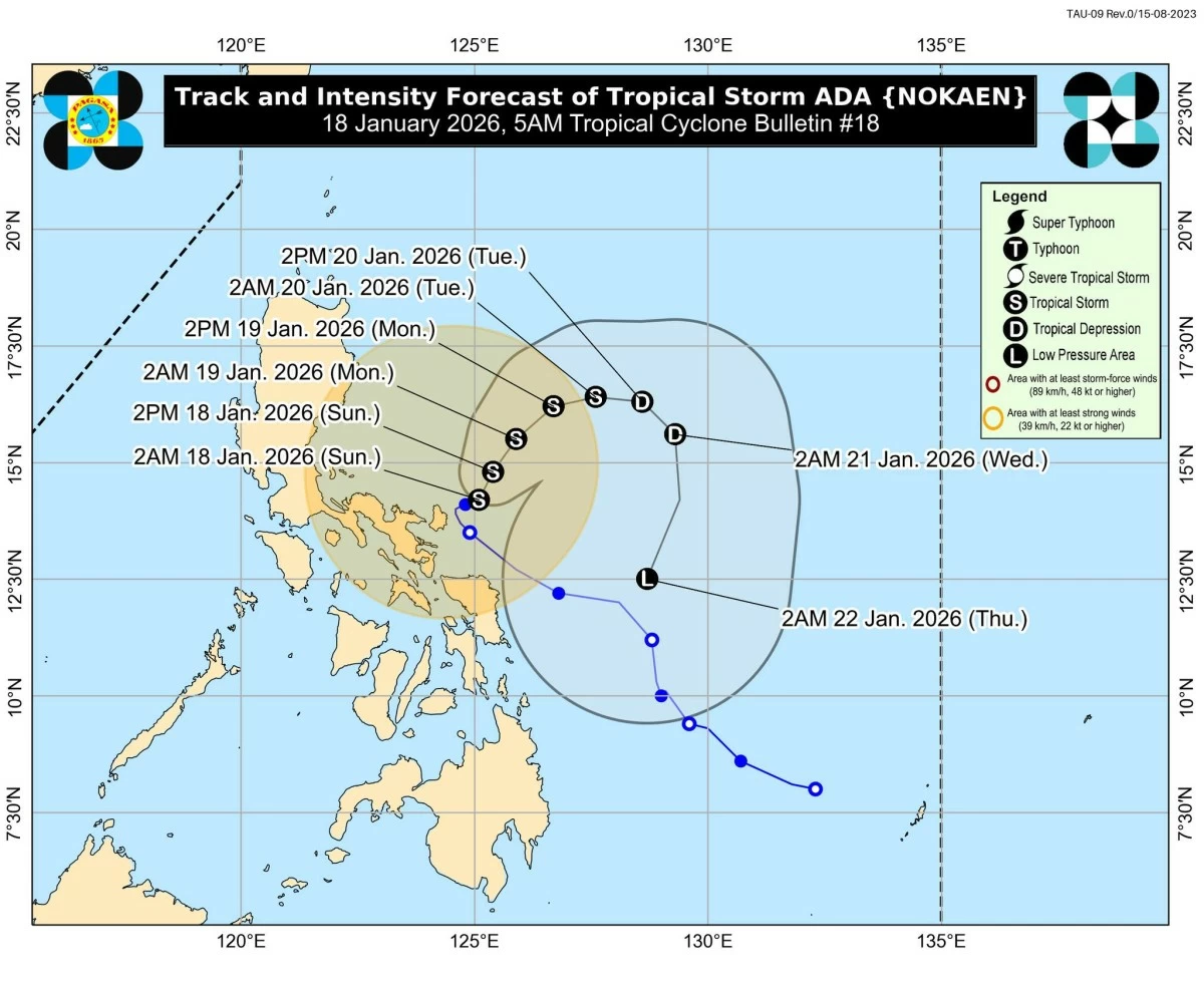
Tropical Storm Ada (international name: Nokaen) has slightly weakened but continues to pose weather hazards over parts of Luzon and the Visayas as it moves slowly east-northeastward, the Philippine Atmospheric, Geophysical and Astronomical Services Administration (PAGASA) said early Sunday, January 18.
In its 5 a.m. tropical cyclone bulletin, PAGASA said Ada was last located 135 kilometers east-northeast of Virac, Catanduanes, or 395 kilometers east of Infanta, Quezon.
Tropical Storm Ada maintains strength, wide wind reach
Ada is packing maximum sustained winds of 75 kilometers per hour, with gusts of up to 90 kph, and a central pressure of 996 hPa.
PAGASA said strong to gale-force winds extend as far as 440 kilometers from the storm’s center, affecting a wide swath of eastern Luzon and nearby waters.
Despite the slight weakening, PAGASA warned that damaging winds, heavy rain, and hazardous sea conditions remain possible in affected areas.
Signal No. 2 raised over Catanduanes, parts of Camarines Sur
PAGASA said Tropical Cyclone Wind Signal (TCWS) No. 2 remains in effect over Catanduanes and the eastern portion of Camarines Sur, including Caramoan.
Areas under Signal No. 2 may experience gale-force winds ranging from 62 to 88 kph, posing a minor to moderate threat to life and property, according to PAGASA.
Signal No. 1 covers large parts of Luzon, Northern Samar
TCWS No. 1, which warns of strong winds of 39 to 61 kph, is hoisted over several areas, including:
Luzon – the southeastern portion of Isabela (Dinapigue, Palanan); Aurora; the eastern portion of Quezon (Tagkawayan, Guinayangan, Lopez, Calauag, Buenavista, San Narciso, San Andres, San Francisco, Mulanay, Catanauan, General Luna, Macalelon, Gumaca, Pitogo, Unisan, Atimonan, Plaridel, Agdangan, Padre Burgos, Quezon, Alabat, Perez, General Nakar, Infanta, Real, Mauban), including the Polillo Islands; Marinduque; the eastern portion of Romblon (Cajidiocan, Magdiwang, San Fernando); Camarines Norte; the rest of Camarines Sur; Albay; Sorsogon; and the northern and central portions of Masbate (Uson, Mobo, Masbate City, Baleno, Aroroy, Mandaon, Milagros, Balud), including Ticao and Burias Islands
Visayas – Northern Samar
Minimal to minor wind impacts are possible in these areas, especially in coastal and upland communities exposed to prevailing winds.
Monsoon to enhance strong winds in northern Luzon, Visayas
PAGASA said the northeast monsoon, enhanced by Ada’s periphery, will also bring strong to gale-force gusts over parts of Batanes, Cagayan, Isabela, Ilocos Norte, Abra, Quezon, Romblon, and Eastern Visayas over the next few days.
Storm surge risk up to 2 meters in Bicol coastal areas
A minimal to moderate storm surge risk, with peak heights of up to 2.0 meters, is forecast within the next 24 hours in low-lying or exposed coastal communities in Camarines Norte, Camarines Sur, Catanduanes, Albay, and Sorsogon.
Residents in coastal areas were advised to stay alert and follow local disaster preparedness measures.
Very rough seas prompt gale warning
PAGASA said a gale warning is in effect over the eastern seaboards of Southern Luzon, where very rough seas of up to 4.5 meters are expected, particularly along the northern and eastern coasts of Catanduanes and Camarines Norte and Sur.
The state weather bureau warned that sea travel is dangerous for all types of vessels in these waters and urged mariners to remain in port or seek shelter immediately.
Ada to weaken further, may become LPA by Thursday
Ada is forecast to move generally northeastward until Monday before following a looping track over the sea east of Luzon.
PAGASA said the storm is expected to remain a tropical storm through Monday, weaken into a tropical depression by Tuesday, and further downgrade into a low-pressure area by Thursday due to the surge of the northeast monsoon. 

Related Tags

Tropical Storm Ada PAGASA update TS Ada weather forecast Philippines Catanduanes storm signal PAGASA PAGASA tropical cyclone bulletin Luzon Visayas storm advisory
ADVERTISEMENT
.most-popular .layout-ratio{ padding-bottom: 79.13%; } @media (min-width: 768px) and (max-width: 1024px) { .widget-title { font-size: 15px !important; } }

{{ articles_filter_1561_widget.title }}

.most-popular .layout-ratio{ padding-bottom: 79.13%; } @media (min-width: 768px) and (max-width: 1024px) { .widget-title { font-size: 15px !important; } }

{{ articles_filter_1562_widget.title }}

.most-popular .layout-ratio{ padding-bottom: 79.13%; } @media (min-width: 768px) and (max-width: 1024px) { .widget-title { font-size: 15px !important; } }

{{ articles_filter_1563_widget.title }}

{{ articles_filter_1564_widget.title }}

.mb-article-details { position: relative; } .mb-article-details .article-body-preview, .mb-article-details .article-body-summary{ font-size: 17px; line-height: 30px; font-family: "Libre Caslon Text", serif; color: #000; } .mb-article-details .article-body-preview iframe , .mb-article-details .article-body-summary iframe{ width: 100%; margin: auto; } .read-more-background { background: linear-gradient(180deg, color(display-p3 1.000 1.000 1.000 / 0) 13.75%, color(display-p3 1.000 1.000 1.000 / 0.8) 30.79%, color(display-p3 1.000 1.000 1.000) 72.5%); position: absolute; height: 200px; width: 100%; bottom: 0; display: flex; justify-content: center; align-items: center; padding: 0; } .read-more-background a{ color: #000; } .read-more-btn { padding: 17px 45px; font-family: Inter; font-weight: 700; font-size: 18px; line-height: 16px; text-align: center; vertical-align: middle; border: 1px solid black; background-color: white; } .hidden { display: none; }
function initializeAllSwipers() { // Get all hidden inputs with cms_article_id document.querySelectorAll('[id^="cms_article_id_"]').forEach(function (input) { const cmsArticleId = input.value; const articleSelector = '#article-' + cmsArticleId + ' .body_images'; const swiperElement = document.querySelector(articleSelector); if (swiperElement && !swiperElement.classList.contains('swiper-initialized')) { new Swiper(articleSelector, { loop: true, pagination: false, navigation: { nextEl: '#article-' + cmsArticleId + ' .swiper-button-next', prevEl: '#article-' + cmsArticleId + ' .swiper-button-prev', }, }); } }); } setTimeout(initializeAllSwipers, 3000); const intersectionObserver = new IntersectionObserver( (entries) => { entries.forEach((entry) => { if (entry.isIntersecting) { const newUrl = entry.target.getAttribute("data-url"); if (newUrl) { history.pushState(null, null, newUrl); let article = entry.target; // Extract metadata const author = article.querySelector('.author-section').textContent.replace('By', '').trim(); const section = article.querySelector('.section-info ').textContent.replace(' ', ' '); const title = article.querySelector('.article-title h1').textContent; // Parse URL for Chartbeat path format const parsedUrl = new URL(newUrl, window.location.origin); const cleanUrl = parsedUrl.host + parsedUrl.pathname; // Update Chartbeat configuration if (typeof window._sf_async_config !== 'undefined') { window._sf_async_config.path = cleanUrl; window._sf_async_config.sections = section; window._sf_async_config.authors = author; } // Track virtual page view with Chartbeat if (typeof pSUPERFLY !== 'undefined' && typeof pSUPERFLY.virtualPage === 'function') { try { pSUPERFLY.virtualPage({ path: cleanUrl, title: title, sections: section, authors: author }); } catch (error) { console.error('ping error', error); } } // Optional: Update document title if (title && title !== document.title) { document.title = title; } } } }); }, { threshold: 0.1 } ); function showArticleBody(button) { const article = button.closest("article"); const summary = article.querySelector(".article-body-summary"); const body = article.querySelector(".article-body-preview"); const readMoreSection = article.querySelector(".read-more-background"); // Hide summary and read-more section summary.style.display = "none"; readMoreSection.style.display = "none"; // Show the full article body body.classList.remove("hidden"); } document.addEventListener("DOMContentLoaded", () => { let loadCount = 0; // Track how many times articles are loaded const offset = [1, 2, 3, 4, 5, 6, 7, 8, 9, 10]; // Offset values const currentUrl = window.location.pathname.substring(1); let isLoading = false; // Prevent multiple calls if (!currentUrl) { console.log("Current URL is invalid."); return; } const sentinel = document.getElementById("load-more-sentinel"); if (!sentinel) { console.log("Sentinel element not found."); return; } function isSentinelVisible() { const rect = sentinel.getBoundingClientRect(); return ( rect.top < window.innerHeight && rect.bottom >= 0 ); } function onScroll() { if (isLoading) return; if (isSentinelVisible()) { if (loadCount >= offset.length) { console.log("Maximum load attempts reached."); window.removeEventListener("scroll", onScroll); return; } isLoading = true; const currentOffset = offset[loadCount]; window.loadMoreItems().then(() => { let article = document.querySelector('#widget_1690 > div:nth-last-of-type(2) article'); intersectionObserver.observe(article) loadCount++; }).catch(error => { console.error("Error loading more items:", error); }).finally(() => { isLoading = false; }); } } window.addEventListener("scroll", onScroll); });

Sign up by email to receive news.