ADVERTISEMENT

PAGASA: 'Ada' slightly weakens, parts of Luzon remain on alert

Published Jan 18, 2026 06:18 pm
Tropical Storm Ada slightly weakens but still poses risks of strong winds, storm surges, and rough seas across Luzon. (PAGASA)
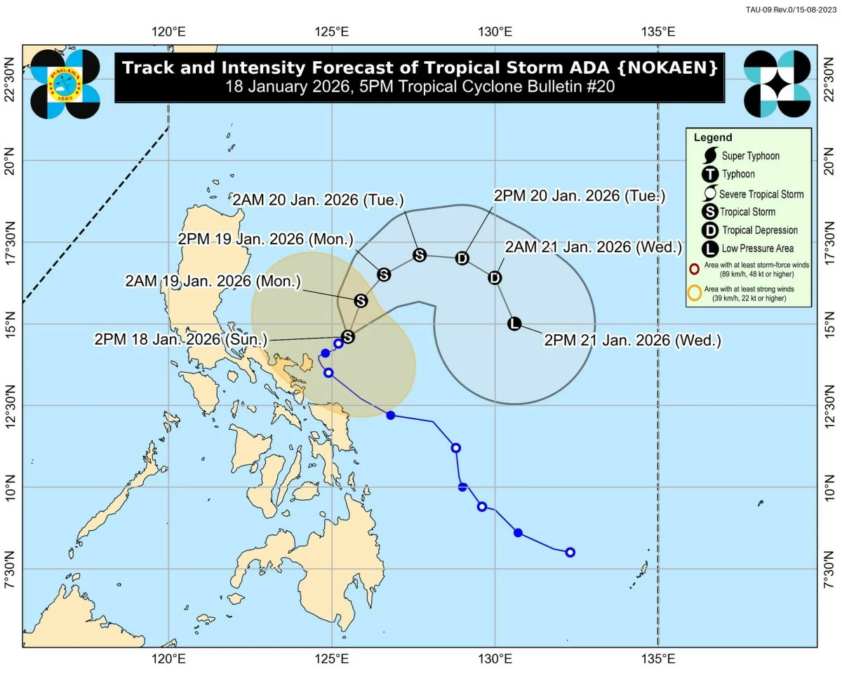
Tropical Storm Ada (international name: Nokaen) slightly weakened on Sunday, January 18, as it moved northeast over the sea near Catanduanes, the Philippine Atmospheric, Geophysical and Astronomical Services Administration (PAGASA) said.
In its 5 p.m. bulletin, PAGASA said the storm’s center was located 205 kilometers northeast of Virac, Catanduanes, as of 4 p.m., packing maximum sustained winds of 65 km/h near the center, with gusts of up to 80 km/h and a central pressure of 998 hPa.
“Ada” is moving slowly northeastward while maintaining a broad wind field, with strong to gale-force winds extending up to 350 km from its center.
Currently, no areas remain under Tropical Cyclone Wind Signal (TCWS) No. 2. However, TCWS Signal No. 1 is still in effect in Catanduanes and the northeastern portion of Camarines Sur, including Garchitorena, Lagonoy, Presentacion, Caramoan, San Jose, Siruma, and Tinambac.
PAGASA also noted that the northeast monsoon (amihan), combined with “Ada’s” effects, will bring strong to gale-force gusts to Batanes, Cagayan, Isabela, Quirino, Ilocos Norte, Aurora, Quezon, the Bicol Region, and parts of Eastern Visayas over the next 24 hours.
Authorities warned of a minimal to moderate risk of storm surge reaching up to 2 meters in low-lying or exposed coastal communities in Camarines Sur and Catanduanes.
Rough sea conditions are expected, with wave heights of up to 4 meters along the eastern seaboards of Isabela and Cagayan, and 3.5 meters in Batanes, the Babuyan Islands, and Camarines Norte.
Mariners, especially small boat operators, were advised not to venture out to sea, while coastal residents were urged to secure property and stay vigilant.
PAGASA forecasts that “Ada” will remain a tropical storm while moving east of Luzon, weakening into a tropical depression by January 20 and further into a low-pressure area by January 21 due to the northeast monsoon surge.
Residents were advised to monitor local advisories, as heavy rainfall and strong winds may still affect areas outside “Ada’s” predicted path. 

Related Tags

Tropical Storm Ada PAGASA weather update Luzon storm alert storm surge warning rough sea conditions
ADVERTISEMENT
.most-popular .layout-ratio{ padding-bottom: 79.13%; } @media (min-width: 768px) and (max-width: 1024px) { .widget-title { font-size: 15px !important; } }

{{ articles_filter_1561_widget.title }}

.most-popular .layout-ratio{ padding-bottom: 79.13%; } @media (min-width: 768px) and (max-width: 1024px) { .widget-title { font-size: 15px !important; } }

{{ articles_filter_1562_widget.title }}

.most-popular .layout-ratio{ padding-bottom: 79.13%; } @media (min-width: 768px) and (max-width: 1024px) { .widget-title { font-size: 15px !important; } }

{{ articles_filter_1563_widget.title }}

{{ articles_filter_1564_widget.title }}

.mb-article-details { position: relative; } .mb-article-details .article-body-preview, .mb-article-details .article-body-summary{ font-size: 17px; line-height: 30px; font-family: "Libre Caslon Text", serif; color: #000; } .mb-article-details .article-body-preview iframe , .mb-article-details .article-body-summary iframe{ width: 100%; margin: auto; } .read-more-background { background: linear-gradient(180deg, color(display-p3 1.000 1.000 1.000 / 0) 13.75%, color(display-p3 1.000 1.000 1.000 / 0.8) 30.79%, color(display-p3 1.000 1.000 1.000) 72.5%); position: absolute; height: 200px; width: 100%; bottom: 0; display: flex; justify-content: center; align-items: center; padding: 0; } .read-more-background a{ color: #000; } .read-more-btn { padding: 17px 45px; font-family: Inter; font-weight: 700; font-size: 18px; line-height: 16px; text-align: center; vertical-align: middle; border: 1px solid black; background-color: white; } .hidden { display: none; }
function initializeAllSwipers() { // Get all hidden inputs with cms_article_id document.querySelectorAll('[id^="cms_article_id_"]').forEach(function (input) { const cmsArticleId = input.value; const articleSelector = '#article-' + cmsArticleId + ' .body_images'; const swiperElement = document.querySelector(articleSelector); if (swiperElement && !swiperElement.classList.contains('swiper-initialized')) { new Swiper(articleSelector, { loop: true, pagination: false, navigation: { nextEl: '#article-' + cmsArticleId + ' .swiper-button-next', prevEl: '#article-' + cmsArticleId + ' .swiper-button-prev', }, }); } }); } setTimeout(initializeAllSwipers, 3000); const intersectionObserver = new IntersectionObserver( (entries) => { entries.forEach((entry) => { if (entry.isIntersecting) { const newUrl = entry.target.getAttribute("data-url"); if (newUrl) { history.pushState(null, null, newUrl); let article = entry.target; // Extract metadata const author = article.querySelector('.author-section').textContent.replace('By', '').trim(); const section = article.querySelector('.section-info ').textContent.replace(' ', ' '); const title = article.querySelector('.article-title h1').textContent; // Parse URL for Chartbeat path format const parsedUrl = new URL(newUrl, window.location.origin); const cleanUrl = parsedUrl.host + parsedUrl.pathname; // Update Chartbeat configuration if (typeof window._sf_async_config !== 'undefined') { window._sf_async_config.path = cleanUrl; window._sf_async_config.sections = section; window._sf_async_config.authors = author; } // Track virtual page view with Chartbeat if (typeof pSUPERFLY !== 'undefined' && typeof pSUPERFLY.virtualPage === 'function') { try { pSUPERFLY.virtualPage({ path: cleanUrl, title: title, sections: section, authors: author }); } catch (error) { console.error('ping error', error); } } // Optional: Update document title if (title && title !== document.title) { document.title = title; } } } }); }, { threshold: 0.1 } ); function showArticleBody(button) { const article = button.closest("article"); const summary = article.querySelector(".article-body-summary"); const body = article.querySelector(".article-body-preview"); const readMoreSection = article.querySelector(".read-more-background"); // Hide summary and read-more section summary.style.display = "none"; readMoreSection.style.display = "none"; // Show the full article body body.classList.remove("hidden"); } document.addEventListener("DOMContentLoaded", () => { let loadCount = 0; // Track how many times articles are loaded const offset = [1, 2, 3, 4, 5, 6, 7, 8, 9, 10]; // Offset values const currentUrl = window.location.pathname.substring(1); let isLoading = false; // Prevent multiple calls if (!currentUrl) { console.log("Current URL is invalid."); return; } const sentinel = document.getElementById("load-more-sentinel"); if (!sentinel) { console.log("Sentinel element not found."); return; } function isSentinelVisible() { const rect = sentinel.getBoundingClientRect(); return ( rect.top < window.innerHeight && rect.bottom >= 0 ); } function onScroll() { if (isLoading) return; if (isSentinelVisible()) { if (loadCount >= offset.length) { console.log("Maximum load attempts reached."); window.removeEventListener("scroll", onScroll); return; } isLoading = true; const currentOffset = offset[loadCount]; window.loadMoreItems().then(() => { let article = document.querySelector('#widget_1690 > div:nth-last-of-type(2) article'); intersectionObserver.observe(article) loadCount++; }).catch(error => { console.error("Error loading more items:", error); }).finally(() => { isLoading = false; }); } } window.addEventListener("scroll", onScroll); });

Sign up by email to receive news.