


(PAGASA)
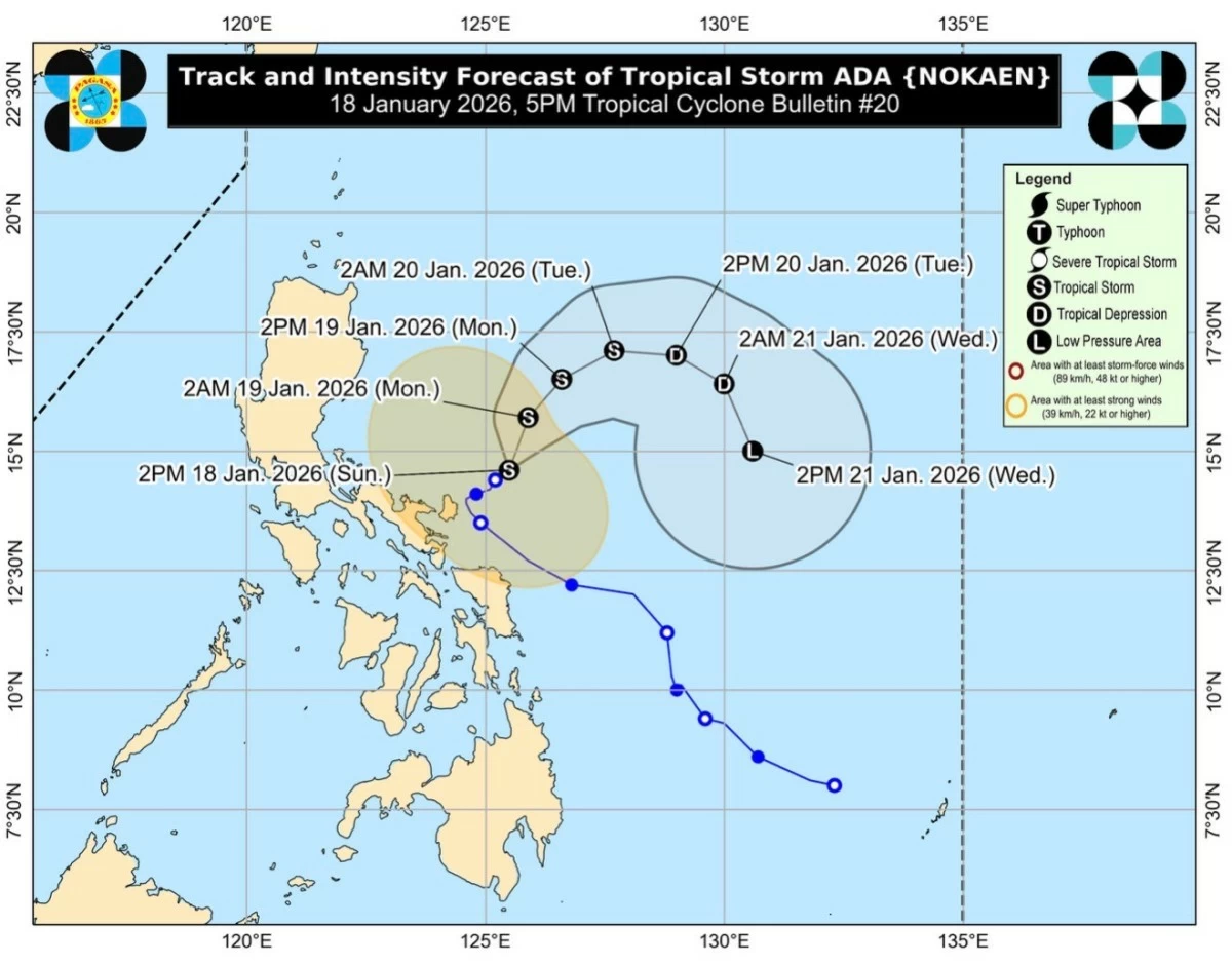
Tropical Storm Ada (international name: Nokaen) is expected to weaken into a tropical depression by Monday, Jan. 19, before further degenerating into a low-pressure area (LPA) by Wednesday, Jan. 21, due to the surge of the northeast monsoon, the Philippine Atmospheric, Geophysical and Astronomical Services Administration said.
“Due to the surge of the northeast monsoon, ADA is forecast to weaken into a tropical depression by tomorrow (19 January) before further weakening into a low pressure area by Wednesday (21 January). An earlier weakening remains possible,” PAGASA said in its Tropical Cyclone Bulletin No. 21, issued at 11 p.m. on Sunday, Jan. 18.
The agency warned that impacts from the cyclone may still be felt beyond its projected path.
“It must be emphasized that heavy rainfall and severe winds may still be experienced in localities outside the landfall point and the forecast confidence cone.”
The state weather bureau said “Ada” is forecast to move generally northeastward until Monday, Jan. 19, after which it is expected to follow a looping track over the sea east of Luzon.
PAGASA said severe winds may be experienced over land areas as the northeast monsoon interacts with the cyclone’s periphery.
“The Northeast Monsoon and the periphery of ADA will also bring strong to gale-force gusts over the following areas (especially in coastal and upland areas exposed to winds).”
According to PAGASA, strong to gale-force gusts may affect Batanes, Cagayan, Isabela, Quirino, Ilocos Norte, Aurora, the Polillo Islands, Camarines Sur, and Catanduanes on Sunday.
Similar conditions may be experienced on Monday (Jan. 19) over Batanes, Cagayan, Isabela, Aurora, the Polillo Islands, Camarines Sur, and Catanduanes.
By Tuesday (Jan. 20), strong winds may impact Batanes, Cagayan, Isabela, Ilocos Norte, Abra, Aurora, Quezon, Marinduque, Romblon, Camarines Norte, Camarines Sur, Catanduanes, Albay, Sorsogon, and Northern Samar.
Meanwhile, PAGASA said no gale warning is currently hoisted over coastal waters.
However, the agency warned of hazardous sea conditions within the next 24 hours.
PAGASA said seas of up to 4.0 meters may be experienced along the seaboard of Isabela and the eastern seaboard of mainland Cagayan, while waves reaching up to 3.5 meters are expected over the eastern seaboard of the Babuyan Islands, the seaboard of northern Aurora, the northern and eastern seaboards of the Polillo Islands, and the northern seaboards of Camarines Sur, Camarines Norte, and Catanduanes.
Meanwhile, seas of up to 3.0 meters may affect the seaboards of Ilocos Norte and Ilocos Sur, the western seaboard of Pangasinan, and the eastern seaboard of Catanduanes.
PAGASA advised sea travel restrictions for small vessels amid the rough sea conditions.
“Mariners of small seacrafts, including all types of motorbancas, are advised not to venture out to sea under these conditions, especially if inexperienced or operating ill-equipped vessels,” the agency said.