


Manila Bulletin
 Philippines
National
Signal No. 2 up in 7 areas as Tropical Storm Ada further intensifies; Signal No. 3 possible
Philippines
National
Signal No. 2 up in 7 areas as Tropical Storm Ada further intensifies; Signal No. 3 possible
Philippines
National
Signal No. 2 up in 7 areas as Tropical Storm Ada further intensifies; Signal No. 3 possible
Signal No. 2 up in 7 areas as Tropical Storm Ada further intensifies; Signal No. 3 possible
Published Jan 17, 2026 07:24 am
|
Updated Jan 17, 2026 01:15 pm


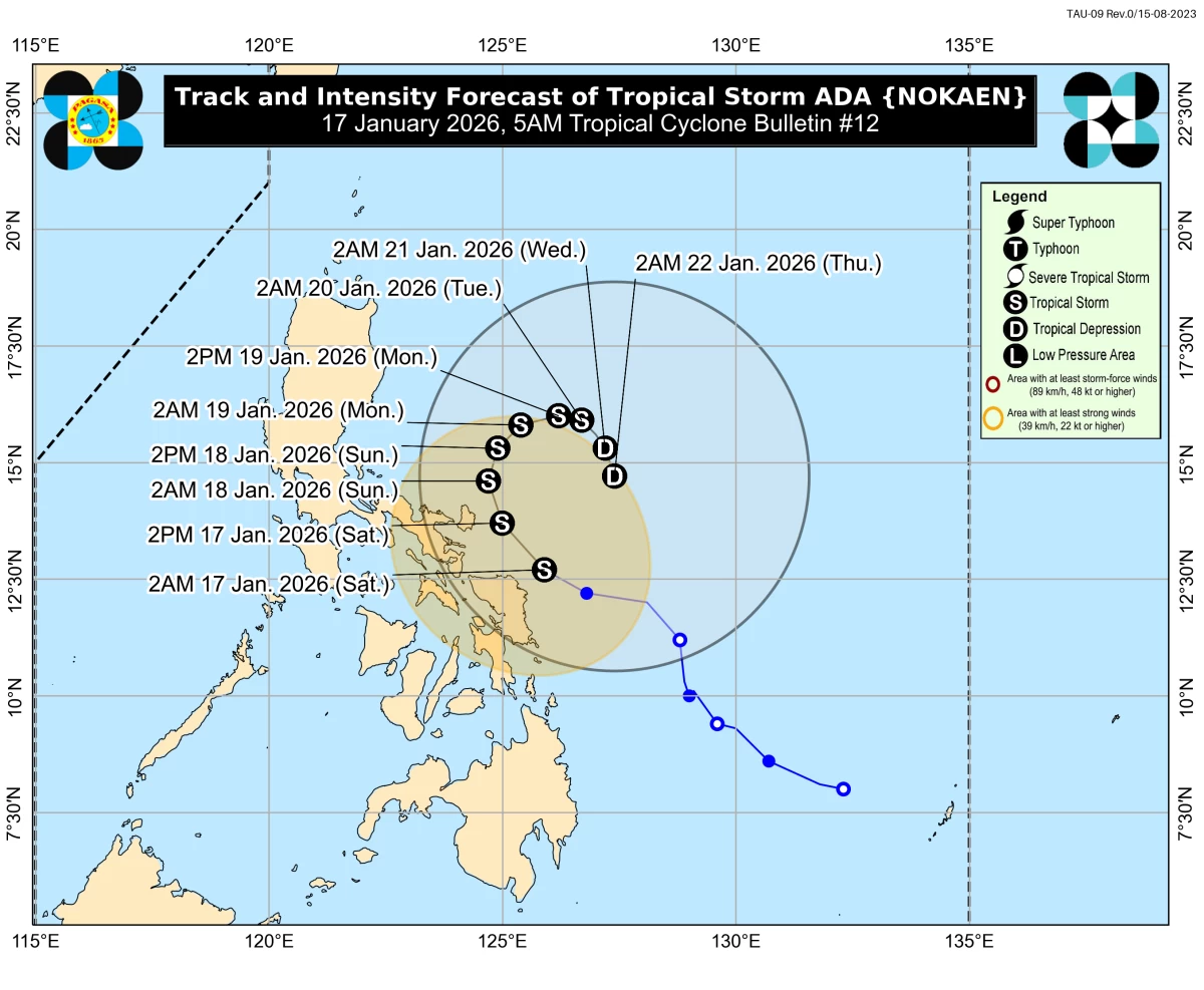
Track and intensity forecast for Tropical Storm Ada (Nokaen) (Courtesy of PAGASA)
The Philippine Atmospheric, Geophysical and Astronomical Services Administration (PAGASA) on Saturday, Jan. 17, raised Wind Signal No. 2 in seven areas as Tropical Storm Ada (Nokaen) strengthened east of Bicol Region, warning that higher wind signals could still be hoisted if the storm intensifies further.
As of 5 a.m., the center of Ada was estimated at 120 kilometers east-northeast of Catarman, Northern Samar, moving west-northwestward at 20 kilometers per hour (kph).
The storm had maximum sustained winds of 85 kph near the center and gusts of up to 105 kph.
Signal No. 2 was raised over the eastern portion of Camarines Sur (Siruma, Tinambac, Ocampo, Baao, Nabua, Bato, Iriga City, Buhi, Sagñay, Tigaon, Goa, Lagonoy, San Jose, Garchitorena, Presentacion, Caramoan, Milaor, Camaligan, Pili, Magarao, Minalabac, Balatan, Naga City, Calabanga, Bombon, Bula, Canaman, and Gainza); Catanduanes, Albay, Sorsogon; Northern Samar; northern portion of Eastern Samar (Jipapad, Maslog, Dolores, Oras, San Policarpo, and Arteche); and northeastern portion of Samar (Matuguinao and San Jose de Buan).
Minor to moderate impacts from gale-force winds are possible in these areas.
Meanwhile, Signal No. 1 remains in effect over the eastern portion of Quezon (Tagkawayan, Guinayangan, Lopez, Calauag, Buenavista, San Narciso, San Andres, San Francisco, Mulanay, Catanauan, General Luna, Macalelon, Gumaca, Pitogo, Unisan, Atimonan, Plaridel, Agdangan, Padre Burgos, Quezon, Alabat, Perez, and Polillo Islands); Marinduque; Camarines Norte; the rest of Camarines Sur; Masbate, including Ticao and Burias Islands; the rest of Eastern Samar; the rest of Samar; Biliran; Leyte; Southern Leyte; northern portion of Cebu (Medellin, Daanbantayan, San Remigio, the City of Bogo, Tabogon, and Camotes and Bantayan Islands); and Dinagat Islands.
Minimal to minor impacts from strong winds may be experienced in these areas.
PAGASA said Ada is forecast to move west-northwestward to northwestward on Saturday before slowly turning generally northward on Sunday, Jan. 18.
From Sunday onward, the storm is expected to move slowly over the sea east of Southern Luzon, with the center possibly passing close to Catanduanes from Saturday afternoon until early Sunday morning.
PAGASA also said a further westward shift in the forecast track could result in a possible landfall over Bicol Region.
Ada is forecast to be near 85 kilometers east of Virac, Catanduanes by 2 p.m. Saturday, 325 kilometers east of Infanta, Quezon by 2 a.m. Sunday, and 350 kilometers east of Infanta by 2 p.m. Sunday.
On Monday, Jan. 19, the storm is expected to be 405 kilometers east of Baler, Aurora by 2 a.m. and 490 kilometers east of Baler by 2 p.m.
By Tuesday, Jan. 20, Ada is forecast to be 545 kilometers east of Baler, and by Wednesday, Jan. 21, 600 kilometers east of Baler.
On Thursday, Jan. 22, the storm is expected to be 615 kilometers east of Infanta, Quezon.
While Ada is expected to remain a tropical storm over the sea east of the Visayas and Southern Luzon, PAGASA said further intensification into a severe tropical storm has not been ruled out.
The tropical cyclone may weaken into a tropical depression by Tuesday, due to the effects of the northeast monsoon, or “amihan.”