ADVERTISEMENT

Signal No. 1 raised over 16 areas as TS Ada moves closer to eastern Philippines

Published Jan 16, 2026 07:00 pm
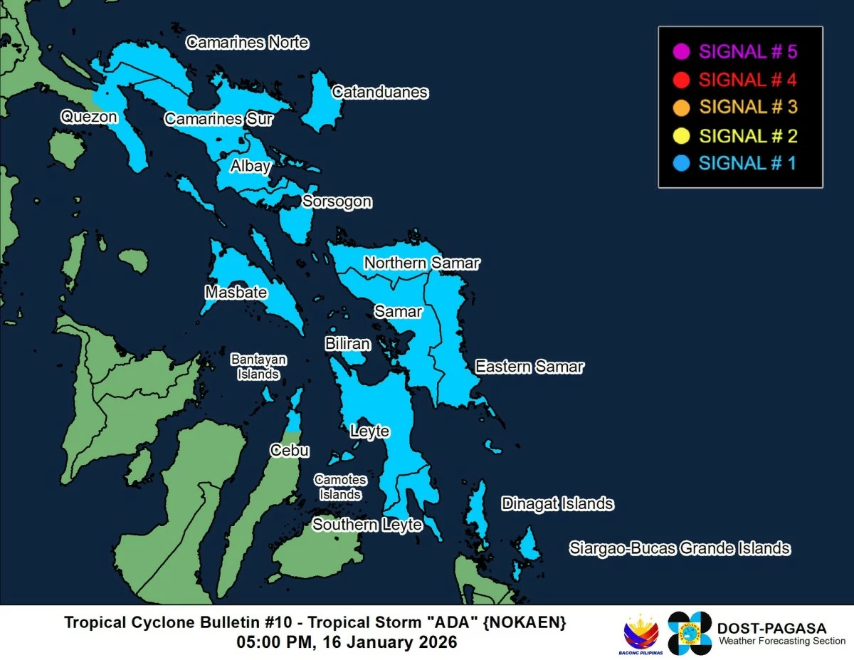
Areas under Wind Signal No. 1 as of 5 p.m., January 16, 2026 due to Tropical Storm Ada (Nokaen). (Courtesy of PAGASA)
More areas were placed under Tropical Cyclone Wind Signal No. 1 as Tropical Storm Ada (international name: Nokaen) continued to move northwest toward the Eastern Visayas-Bicol area on Friday afternoon, Jan. 16, the Philippine Atmospheric, Geophysical and Astronomical Services Administration (PAGASA) said.
As of 5 p.m., the center of Ada was located 335 kilometers east-northeast of Guiuan, Eastern Samar, moving northwestward at 20 kilometers per hour (kph).
It had maximum sustained winds of 65 kph near the center and gustiness of up to 80 kph.
PAGASA warned that minimal to minor impacts from strong winds are possible in areas under Signal No. 1, while the highest wind signal that may be hoisted during the storm’s passage is Signal No. 2.
Signal No. 1 was hoisted over the southern portion of Quezon (San Narciso, Mulanay, San Francisco, San Andres, Buenavista, Catanauan, Lopez, Calauag, Guinayangan, Tagkawayan), Camarines Norte, Camarines Sur, Catanduanes, Albay, Sorsogon, Masbate, Northern Samar, Samar, Eastern Samar, Biliran, Leyte, Southern Leyte, northern portion of Cebu (Medellin, Daanbantayan, San Remigio, City of Bogo, Tabogon, Camotes Islands, Bantayan Islands, Dinagat Islands, and Siargao-Bucas Grande Islands.
PAGASA also warned of a minimal to moderate risk of storm surge, with peak heights of up to two meters expected over the next 48 hours in low-lying or exposed coastal communities of Camarines Sur, Catanduanes, Albay, Sorsogon, Northern Samar, Eastern Samar, and Samar.
Ada is forecast to continue moving generally northwestward through Saturday, Jan. 17, before turning slowly north-northwestward to northeastward by Sunday, Jan. 18.
From Sunday onwards, the storm is expected to move slowly or become nearly stationary over the sea northeast of Catanduanes.
On its current track, the center of Ada may pass close to Eastern Samar and Northern Samar on Saturday, and near Catanduanes from Saturday evening through Sunday.
PAGASA noted that a westward shift in the forecast track could result in a possible landfall over Eastern Visayas and Bicol Region.
The tropical cyclone is expected to remain at tropical storm intensity while over the sea east of Visayas and Southern Luzon.
It may weaken into a tropical depression by Tuesday, Jan. 20, and further into a remnant low by Wednesday, January 21, as it is affected by the northeast monsoon, or “amihan.”

Related Tags

PAGASA TROPICAL STORM ADA NOKAEN SIGNAL NO. 1
ADVERTISEMENT
.most-popular .layout-ratio{ padding-bottom: 79.13%; } @media (min-width: 768px) and (max-width: 1024px) { .widget-title { font-size: 15px !important; } }

{{ articles_filter_1561_widget.title }}

.most-popular .layout-ratio{ padding-bottom: 79.13%; } @media (min-width: 768px) and (max-width: 1024px) { .widget-title { font-size: 15px !important; } }

{{ articles_filter_1562_widget.title }}

.most-popular .layout-ratio{ padding-bottom: 79.13%; } @media (min-width: 768px) and (max-width: 1024px) { .widget-title { font-size: 15px !important; } }

{{ articles_filter_1563_widget.title }}

{{ articles_filter_1564_widget.title }}

.mb-article-details { position: relative; } .mb-article-details .article-body-preview, .mb-article-details .article-body-summary{ font-size: 17px; line-height: 30px; font-family: "Libre Caslon Text", serif; color: #000; } .mb-article-details .article-body-preview iframe , .mb-article-details .article-body-summary iframe{ width: 100%; margin: auto; } .read-more-background { background: linear-gradient(180deg, color(display-p3 1.000 1.000 1.000 / 0) 13.75%, color(display-p3 1.000 1.000 1.000 / 0.8) 30.79%, color(display-p3 1.000 1.000 1.000) 72.5%); position: absolute; height: 200px; width: 100%; bottom: 0; display: flex; justify-content: center; align-items: center; padding: 0; } .read-more-background a{ color: #000; } .read-more-btn { padding: 17px 45px; font-family: Inter; font-weight: 700; font-size: 18px; line-height: 16px; text-align: center; vertical-align: middle; border: 1px solid black; background-color: white; } .hidden { display: none; }
function initializeAllSwipers() { // Get all hidden inputs with cms_article_id document.querySelectorAll('[id^="cms_article_id_"]').forEach(function (input) { const cmsArticleId = input.value; const articleSelector = '#article-' + cmsArticleId + ' .body_images'; const swiperElement = document.querySelector(articleSelector); if (swiperElement && !swiperElement.classList.contains('swiper-initialized')) { new Swiper(articleSelector, { loop: true, pagination: false, navigation: { nextEl: '#article-' + cmsArticleId + ' .swiper-button-next', prevEl: '#article-' + cmsArticleId + ' .swiper-button-prev', }, }); } }); } setTimeout(initializeAllSwipers, 3000); const intersectionObserver = new IntersectionObserver( (entries) => { entries.forEach((entry) => { if (entry.isIntersecting) { const newUrl = entry.target.getAttribute("data-url"); if (newUrl) { history.pushState(null, null, newUrl); let article = entry.target; // Extract metadata const author = article.querySelector('.author-section').textContent.replace('By', '').trim(); const section = article.querySelector('.section-info ').textContent.replace(' ', ' '); const title = article.querySelector('.article-title h1').textContent; // Parse URL for Chartbeat path format const parsedUrl = new URL(newUrl, window.location.origin); const cleanUrl = parsedUrl.host + parsedUrl.pathname; // Update Chartbeat configuration if (typeof window._sf_async_config !== 'undefined') { window._sf_async_config.path = cleanUrl; window._sf_async_config.sections = section; window._sf_async_config.authors = author; } // Track virtual page view with Chartbeat if (typeof pSUPERFLY !== 'undefined' && typeof pSUPERFLY.virtualPage === 'function') { try { pSUPERFLY.virtualPage({ path: cleanUrl, title: title, sections: section, authors: author }); } catch (error) { console.error('ping error', error); } } // Optional: Update document title if (title && title !== document.title) { document.title = title; } } } }); }, { threshold: 0.1 } ); function showArticleBody(button) { const article = button.closest("article"); const summary = article.querySelector(".article-body-summary"); const body = article.querySelector(".article-body-preview"); const readMoreSection = article.querySelector(".read-more-background"); // Hide summary and read-more section summary.style.display = "none"; readMoreSection.style.display = "none"; // Show the full article body body.classList.remove("hidden"); } document.addEventListener("DOMContentLoaded", () => { let loadCount = 0; // Track how many times articles are loaded const offset = [1, 2, 3, 4, 5, 6, 7, 8, 9, 10]; // Offset values const currentUrl = window.location.pathname.substring(1); let isLoading = false; // Prevent multiple calls if (!currentUrl) { console.log("Current URL is invalid."); return; } const sentinel = document.getElementById("load-more-sentinel"); if (!sentinel) { console.log("Sentinel element not found."); return; } function isSentinelVisible() { const rect = sentinel.getBoundingClientRect(); return ( rect.top < window.innerHeight && rect.bottom >= 0 ); } function onScroll() { if (isLoading) return; if (isSentinelVisible()) { if (loadCount >= offset.length) { console.log("Maximum load attempts reached."); window.removeEventListener("scroll", onScroll); return; } isLoading = true; const currentOffset = offset[loadCount]; window.loadMoreItems().then(() => { let article = document.querySelector('#widget_1690 > div:nth-last-of-type(2) article'); intersectionObserver.observe(article) loadCount++; }).catch(error => { console.error("Error loading more items:", error); }).finally(() => { isLoading = false; }); } } window.addEventListener("scroll", onScroll); });

Sign up by email to receive news.