


Manila Bulletin
 Philippines
National
'Ada' to batter eastern Philippines with heavy rains, gusty winds until early next week; lahars possible in Mayon, Kanlaon
Philippines
National
'Ada' to batter eastern Philippines with heavy rains, gusty winds until early next week; lahars possible in Mayon, Kanlaon
Philippines
National
'Ada' to batter eastern Philippines with heavy rains, gusty winds until early next week; lahars possible in Mayon, Kanlaon
'Ada' to batter eastern Philippines with heavy rains, gusty winds until early next week; lahars possible in Mayon, Kanlaon
Published Jan 16, 2026 01:07 pm


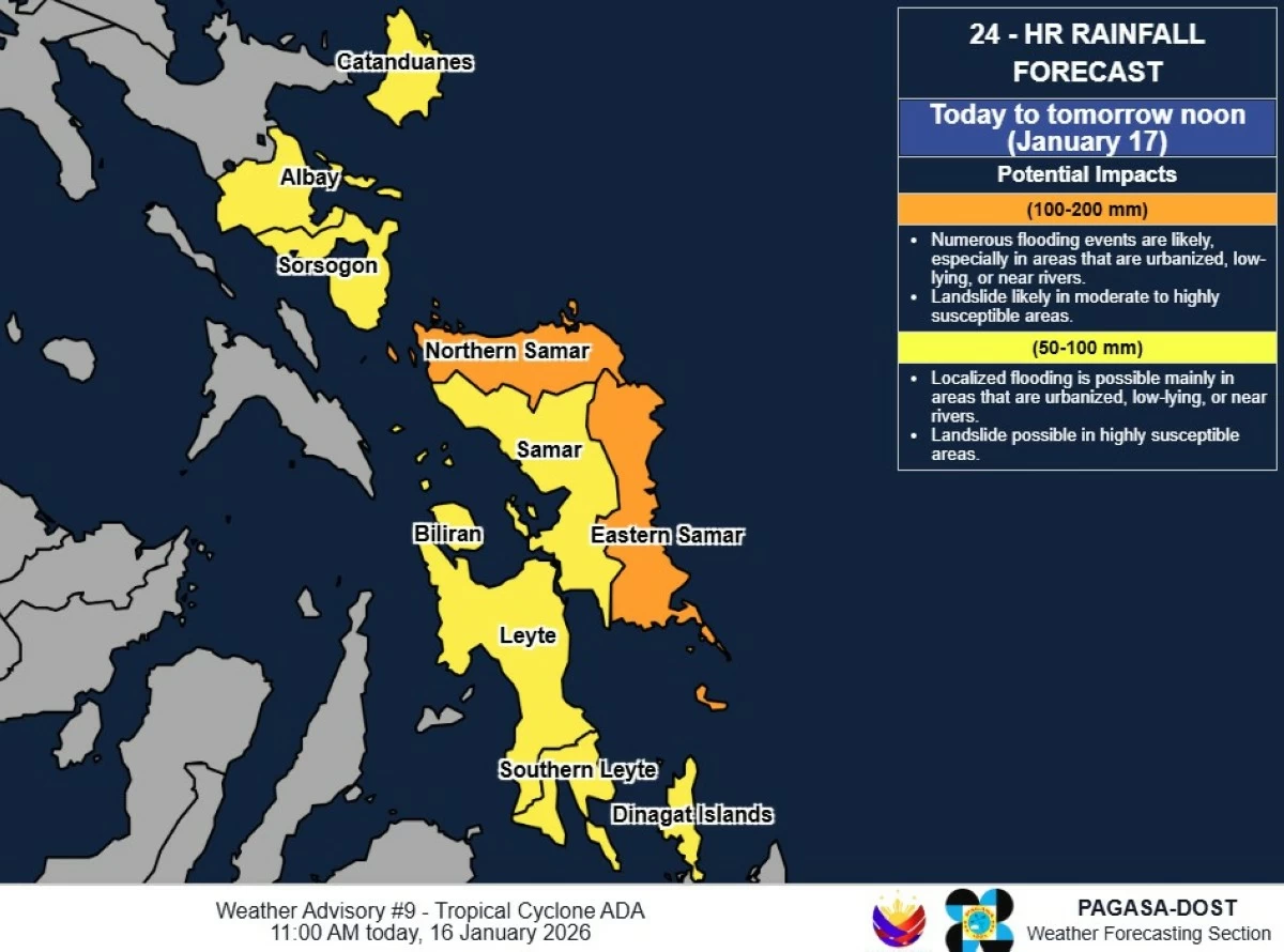
Heavy rainfall outlook (PAGASA)
Tropical Storm Ada (international name: Nokaen) is expected to bring several days of rains and gusty winds over eastern Philippines, particularly Eastern Visayas, Bicol Region, and Caraga, the Philippine Atmospheric, Geophysical and Astronomical Services Administration (PAGASA) said on Friday, Jan. 16.
As of 11 a.m., the center of Ada was located 325 kilometers east of Guiuan, Eastern Samar, moving northward at 15 kilometers per hour (kph).
It has maximum sustained winds of 65 kph near the center and gustiness of up to 80 kph.
PAGASA said Ada is seen to move generally northwestward on Friday and Saturday, Jan. 17 before turning slowly north-northwestward to northeastward by Sunday, Jan. 18.
Beginning Tuesday evening, Jan. 20, it is expected to move southeastward over the sea east of Bicol Region.
On the current track, the storm may pass close to Eastern Samar and Northern Samar on Saturday and Catanduanes from Saturday evening through Sunday.
PAGASA said a westward shift in the forecast track could result in a possible landfall over Eastern Visayas and Bicol Region.
Strong winds, heavy rains
PAGASA pointed out that the highest tropical cyclone wind signal that may be hoisted throughout the passage of Ada is Signal No. 2.
Currently, Signal No. 1 remains hoisted over the eastern portion of Camarines Norte (Mercedes, Basud, San Lorenzo Ruiz, San Vicente, Daet, Talisay, Vinzons); Camarines Sur; Catanduanes; Albay; Sorsogon; eastern portion of mainland Masbate (Pio V. Corpuz, Cataingan, Palanas, Dimasalang, Uson, Mobo, City of Masbate, Baleno, Aroroy) including Ticao and Burias Islands; Northern Samar; Samar; Eastern Samar; Biliran; northern and central portions of Leyte (Carigara, Barugo, San Miguel, Babatngon, Tacloban City, Tunga, Jaro, Alangalang, Santa Fe, Palo, Dagami, Pastrana, Tanauan, Tabontabon, Julita, Dulag, Tolosa, La Paz, Mayorga, Macarthur, Javier, Abuyog, Mahaplag, Kananga, Capoocan, Leyte, Calubian, San Isidro, Tabango, Burauen, Ormoc City, Matag-Ob, Villaba, Albuera, Palompon, Merida, Isabel, City of Baybay); eastern portion of Southern Leyte (Silago, Sogod, Libagon, Saint Bernard, Hinunangan, Hinundayan, Anahawan, San Juan, Liloan, San Ricardo, San Francisco, Pintuyan); Dinagat Islands; and Siargao-Bucas Grande Islands.
Rains are also expected over Eastern Visayas, Catanduanes, Sorsogon, Dinagat Islands, Surigao del Norte, and Surigao del Sur on Friday and Saturday.
Cloudy skies with scattered rains and thunderstorms may prevail over the rest of Bicol Region, Caraga, the rest of Visayas, Northern Mindanao, and Zamboanga del Norte due to Ada.
Light rains are forecast over the Cordillera Administrative Region, Cagayan Valley, and Aurora from the northeast monsoon, or “amihan,” while partly cloudy to cloudy skies with isolated light rains will occur over Ilocos Region, Central Luzon, and Metro Manila.
The rest of the country may experience partly cloudy to cloudy skies with isolated rain showers or thunderstorms due to localized conditions.
On Sunday and Monday, rains with gusty winds due to the storm will affect Camarines Norte, Camarines Sur, Catanduanes, Albay, Sorsogon, and Northern Samar, with scattered rains and thunderstorms over Quezon, the rest of Bicol Region, and Eastern Visayas.
Light amihan rains may continue over Cagayan Valley, Apayao, Kalinga, and Aurora, while Ilocos Region, the rest of Central Luzon, Cordillera, and Metro Manila may experience isolated light rains.
From Tuesday through Friday, Jan. 23, scattered rains and thunderstorms will persist over Quezon, Bicol Region, and Northern Samar due to Ada, while light rains may persist in Cagayan Valley, Apayao, Kalinga, and Aurora due to the amihan.
The rest of the country may see partly cloudy to cloudy skies with isolated rain showers or thunderstorms.
Ada is expected to remain a tropical storm while over the sea east of Visayas and Southern Luzon and may weaken into a tropical depression by Tuesday.
Lahar risk
As Tropical Storm Ada may bring light to moderate with occasionally heavy rains to Bicol Region and Negros Island, the Philippine Institute of Volcanology and Seismology (Phivolcs) said the weather disturbance could generate volcanic sediment flows or lahars, sediment-laden streamflows, or muddy run-off and related siltation in rivers and drainage areas on Mayon Volcano and Kanlaon Volcano.
Phivolcs recommended increased vigilance and readiness of communities in pre-determined zones of lahar and related hazards on these volcanoes.
In a lahar advisory issued at 6 a.m. on Friday, the agency said the storm is expected to bring rainfall of 100 to 200 millimeters, which could remobilize loose volcanic deposits on Mayon’s slopes.
New pyroclastic density current (PDC) deposits from the volcano’s ongoing eruption are particularly vulnerable to heavy rainfall.
“These erodible deposits occupy the Mi-isi, Bonga, and Basud gullies and may feed generally in-channel but hot lahars along the Mi-isi and Binaan channels in Daraga; Mabinit, Bonga, Matanag, Buyuan, and Padang in Legazpi City; and the Lidong and Basud rivers in Santo Domingo,” Phivolcs said. Hot lahars could cause scalding upon contact, potentially resulting in serious or life-threatening injuries, the agency warned.
Older eruption deposits on Mayon’s southwestern slopes may also be remobilized as non-eruption lahars, particularly along the Masarawag, Maninila, and related distributary channels in Guinobatan.
Lahars can threaten downstream communities through inundation, strong impact from boulder-laden flows, burial, and washout, including areas extending to the sea along the volcano’s eastern slopes.
Likewise, prolonged heavy rainfall could generate life-threatening lahars and sediment-laden streamflows on major channels draining the southern, western, and eastern slopes of Kanlaon Volcano.
Post-eruption lahars can form when heavy rainfall erodes loose material from remnant PDC deposits of recent explosive eruptions and ashfall mostly from recent ash emission events.
Non-eruption lahars could also form when areas on the upper slopes recently exposed by landslides or weakened during Supertyphoon Tino in November 2025 feed debris to rivers that have already delivered destructive flows to downstream communities.
Communities of Bago City, La Carlota City, La Castellana, Moises Padilla, and San Carlos City in Negros Occidental, and Canlaon City in Negros Oriental, situated along the Ibid, Cotcot, Talaptapan, Malaiba, Panubigan, Buhangin–Indurayan, Najalin, Inyawan, Maragandang, Panun-an, Intiguiwan, Camansi, Maao, Tokon-tokon, Masulog, Binalbagan, Taco, and Linothangan rivers and creeks, may be affected by lahars and sediment-laden streamflows, including flooding and siltation.
These communities, as well as those further downstream, are advised to be prepared for possible evacuation and to avoid traversing affected streams.