


Geography, history, and imagination in maps
Admiring the art of cartography
Published Jan 10, 2026 07:20 am


At A Glance
- There are more than 80 maps on show, some more than 400 years old.
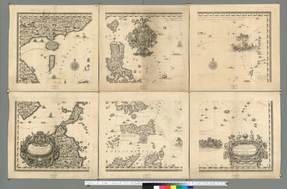
'CARTA CHOROGRAPHICO DEL ARCHIPELAGO' A map of the Philippines made in 1727. (Photo British Library)
Before satellites and jets, people crossed the seas guided by stars and propelled by currents and wind. They drew maps to hint at lands and peoples beyond the horizon, perils and rewards that await.
An exhibit at the National Museum’s Cebu branch presents, through maps, the story of Europeans in the Philippines. The maps, lent mostly by members of the Philippine Map Collectors’ Society (PHIMCOS), show their growing knowledge of the shapes and location of islands, colonial expansion, regional and international trade, and disputes among themselves.
There are more than 80 maps on show, some more than 400 years old. They cover not only geography and history but also artistry and science. History is related in cartouches and coats of arms. Vignettes show the ships they sailed, natives they saw, mermaids and monsters they imagined, saints and cherubs that guided their way. Compass roses and globe gores demonstrate the science of navigation and the practices of cartography.
Highlights of the exhibition, entitled “Classics of Philippine Cartography,” include the following.
Venturing into the unknown
“Zzubu and Mattam” (Pigafetta, 1521). The profitable spice trade was monopolized by Portugal who discovered and controlled the route to the Spice Islands around Africa and across the Indian Ocean. Spain dispatched Ferdinand Magellan to find an alternative route, via the Pacific Ocean. Magellan succeeded in crossing the Pacific but reached the Philippines instead. The expedition’s chronicler, Pigafetta, drew and published the first map of islands in the archipelago, a distorted Cebu and Mactan.
Exploring the Far East
“Terza Tavola” (Gastaldi, 1554). This is the first map that indicates “Filipinas.” Out of Magellan’s five ships, one successfully returned to Spain, proving that the Spice Islands could be reached by sailing west across the Atlantic and the Pacific Oceans. Spain dispatched other expeditions, including one by Villalobos, who named the island of Leyte, Filipina, after Spain’s Principe de Asturias, who later became King Philip II. Feedback from these expeditions contributed to this map that shows some islands of the Visayas, the South China Sea, and China itself.
“Indiae Orientalis” (Ortelius, 1592). The map extends from India to Japan but includes only parts of the Philippine archipelago. The Spanish had already begun to colonize the Philippines under Miguel Lopez de Legaspi, who arrived in Cebu in 1565. They reached Luzon and founded the City of Manila in 1571. News, however, had not reached European cartographers, and Luzon is therefore still absent from this map.
The archipelago explored
“Insulae Philippinae” (Kaerius, 1600). A small map that is the first to show the Philippine archipelago in its entirety. Islands are still misshapen, and many are missing.
“Typus Freti Manilensis” (Spilbergen, 1610). The route taken by a Dutch explorer and privateer (i.e., pirate), which is also the route of the Manila Galleon from Manila Bay to the Pacific Ocean via the southern edge of Luzon down to Sorsogon and San Bernardino Strait. Curiously, small figures, apparently prostitutes, offer services to a warrior and a friar.
The Spanish Empire
“Aspecto simbólico del Mundo Hispano” (Memije, 1761, reproduction). A chart showing the Spanish Empire as a woman with her crown and head in the Iberian peninsula, torso in the Americas, skirt across the Pacific and the Marianas, and feet in the Philippines.
“Carta Hydrographica y Chorographica de las Yslas Filipinas” (Murillo Velarde, 1734). The reproduction of the famous Murillo Velarde map is the most authoritative map as of that date.
The map was used in the arbitration case filed by the Philippines with the United Nations Convention on the Law of the Sea (UNCLOS) over Scarborough Shoal, which is being claimed by China. The Murillo Velarde map includes features in the China Sea named Panacot (later called Bajo de Masinloc, now Scarborough Shoal), Lumbay, and Galit. It also includes the Bajos de Paragua and the Spratly Islands.
It also includes 10 vignettes of life in the Philippines and two smaller maps. Other editions of the map are also in the exhibit, including one (1788) that depicts St. Francis Xavier, who was thought at that time to have preached in the Philippines. The figures allude to the legend that a crab retrieved a cross that the Saint dropped into the sea.
International trade—Nao de China
“Carte de la Mer du Sud” (Bellin, 1751). A chart showing the Pacific Ocean from the Philippines to the California Coast, indicating the route of the Manila Galleon, going north to the 39th latitude and then east to the Americas. Navigation lines and a compass rose show directions.
“Selden Map Showing Trading Routes across the China Sea” (c. 1620). This is a reproduction of a manuscript map in Oxford University’s Bodleian Library. It shows various ports around the China Sea, including Vigan and Manila, that were reached by Chinese trading vessels. The map would include the route of ships bringing Asian goods intended for the Galleon Trade.
“Carta Particolare del mare di Cocincina” (Dudley, 1661). The map shows the West Philippine Sea (labeled Mare delle Filipppine) and La Seccagna di Bollinao (Scarborough Shoal). It antedates the Murillo Velarde Map by 73 years.
“Globe Gore Showing the Philippines and Parts of China and Japan” (Coronelli, 1693). The Earth is a three-dimensional globe, and a map is a two-dimensional surface. Representing the surface of a globe on a flat sheet is obviously a problem. This has been solved by drawing 12 sections of the Earth and assembling these on a globe or a ball. The maps in the exhibit are three of 12 gores that show the Philippines and nearby countries.
The Philippines and European disputes
“A New Map of the Philippine Islands” (Kitchin, 1765). A version of the 1734 Murillo Velarde Map that was published after the 1762-1764 British Occupation of Manila.
“Mapa de las Islas Filipinas, Jolo y Borneo” (La viuda de Roldán, Madrid, 1885, reproduction). Various European countries had wanted to establish themselves in the region. The map shows the boundary established by Spain, the UK, and Germany covering Sulu and Borneo. Under the agreement, Spain relinquished all claims to Borneo. The Sultanate of Jolo considered itself independent, but Spain claimed it anyway.
Notes: (a) The exhibit was organized by the National Museum of the Philippines and the PHIMCOS and is being held at the National Museum Branch in Cebu City from July 5, 2025 to Jan. 31, 2026; (b) The exhibit items are loans from PHIMCOS members including PHIMCOS president Jaime C. Gonzalez, Peter Geldart, Andoni M. Aboitiz, and Margarita Villalon Binamira and from the Presidential Library and Museum and several European institutions; (c) A compass rose is a circular drawing on a map or chart that shows the four cardinal (N, S, E, W) and intermediate directions to guide navigators; and (d) A cartouche is an ornamental frame around an inscription.
Comments are cordially invited, addressed to [email protected].