ADVERTISEMENT

At least 16 dead in flooding and tornadoes as storms slash from Texas to Ohio

Published Apr 6, 2025 12:24 am

DYERSBURG, Tennessee. (AP) — Another round of torrential rain and flash flooding came Saturday for parts of the South and Midwest already heavily waterlogged by days of severe storms that also spawned deadly tornadoes. Forecasters warned that rivers in some places would continue to rise for days.

AP25095738889642.jpg
A car is stuck in floodwaters near the corner of Cowden Street and Tanglewood Avenue as heavy rain falls, Saturday, April 5, 2025, in Memphis, Tenn. (Patrick Lantrip/Daily Memphian via AP)

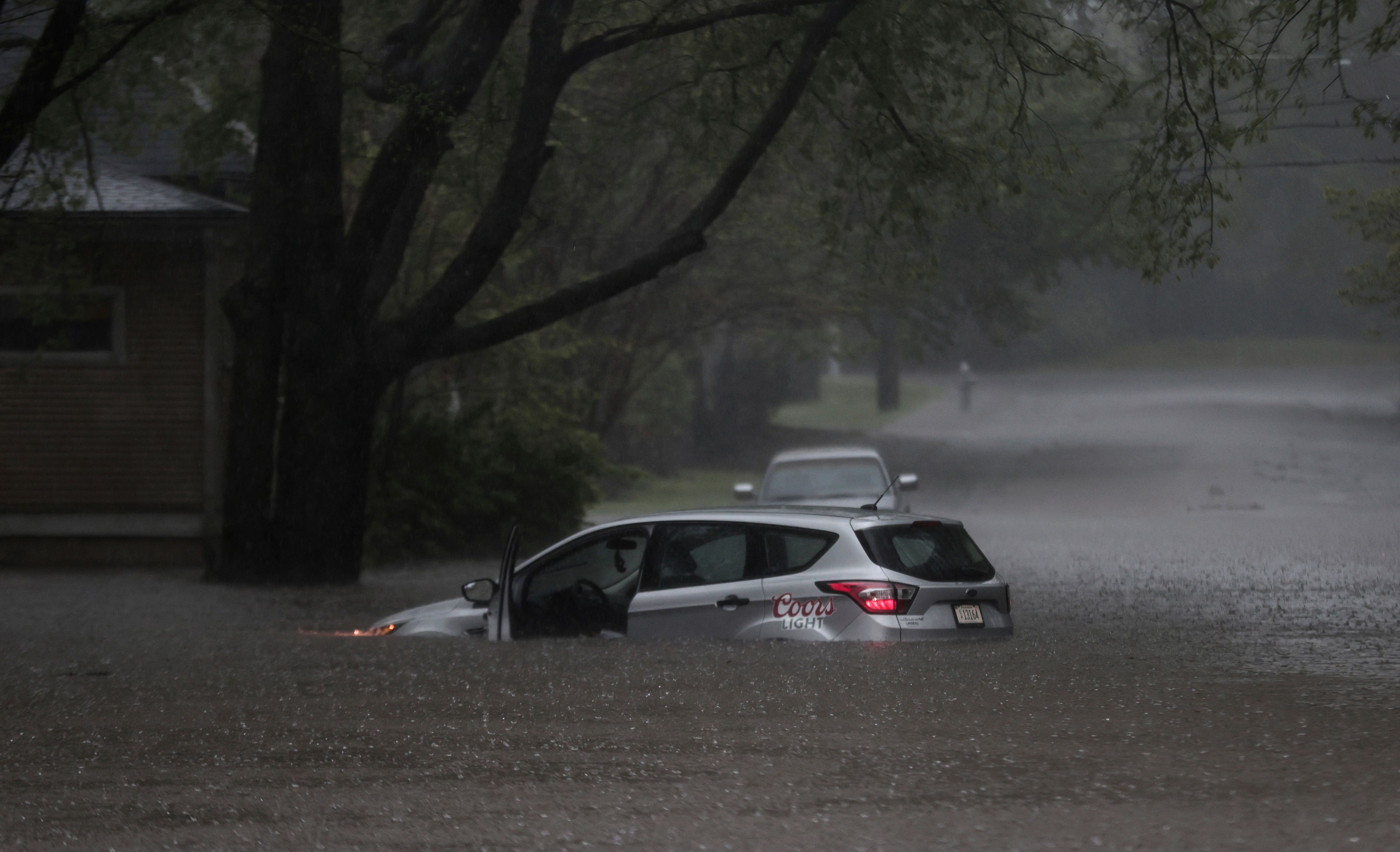
Day after day of heavy rains have pounded the central U.S., rapidly swelling waterways and prompting a series of flash flood emergencies in from Texas to Ohio. The National Weather Service said dozens of locations in multiple states were expected to reach major flood stage, with extensive flooding of structures, roads, bridges and other critical infrastructure possible.


At least 16 people weather-related deaths have been reported since the start of the storms, including 10 in Tennessee.


A 57-year-old man died Friday evening after getting out of a car that washed off a road in West Plains, Missouri. Flooding killed two people in Kentucky — a 9-year-old boy swept away that same day on his way to school, and a 74-year-old whose body was found Saturday inside a fully submerged vehicle in Nelson County, authorities said.


Also Saturday a 5-year-old died at a home in Little Rock, Arkansas, in a weather-related incident, according to police. No details were immediately provided.


Tornadoes earlier in the week destroyed entire neighborhoods and were responsible for at least seven of the deaths.


And interstate commerce is affected — the extreme flooding across a corridor that includes the major cargo hubs in Louisville, Kentucky and Memphis could lead to shipping and supply chain delays, said Jonathan Porter, chief meteorologist at AccuWeather.


The outburst comes at a time when nearly half of NWS forecast offices have 20% vacancy rates after Trump administration job cuts — twice that of just a decade ago.


Louisville Mayor Craig Greenberg said Saturday that the Ohio River rose 5 feet (about 1.5 meters) in 24 hours and would continue to swell for days.


“We expect this to be one of the top 10 flooding events in Louisville history,” he said.


Flash flood threat looms over many states

Flash flood emergency and tornado warnings continued to be issued Saturday across Arkansas, Mississippi and Tennessee, with more heavy rains and damaging winds in the mix.


Hundreds of Kentucky roads were impassable because of floodwaters, downed trees or mud and rock slides.


Downtown Hopkinsville, Kentucky, reopened in the morning after floodwaters from the Little River receded, giving a much-needed reprieve, but still more rainfall was on its way Saturday and Sunday, Mayor James R. Knight Jr. said.


“We got a little rain, but most of it went north of us,” Knight said. “Thank goodness on that. Gave us a little break.”


In north-central Kentucky, emergency officials ordered a mandatory evacuation for Falmouth, a town of 2,000 people in a bend of the rising Licking River. The warnings were similar to catastrophic flooding nearly 30 years ago when the river reached a record 50 feet (15 meters), resulting in five deaths and 1,000 homes destroyed.


In Arkansas, weather officials pleaded with people to avoid travel unless absolutely necessary due to widespread flooding.


BNSF Railway confirmed that a railroad bridge in Mammoth Spring was washed out by floodwaters, causing the derailment of several cars. No injuries were reported, but there was no immediate estimate for when the bridge would reopen.


Why so much nasty weather?

Since Wednesday more than a foot of rain (30.5 centimeters) has fallen in parts of Kentucky, and more than 8 inches (20 centimeters) in parts of Arkansas and Missouri, forecasters said Saturday.


Forecasters attributed the violent weather to warm temperatures, an unstable atmosphere, strong wind shear and abundant moisture streaming from the Gulf.


At least two reports of observed tornadoes were noted Friday evening in Missouri and Arkansas, according to the National Weather Service. One, near Blytheville, Arkansas, lofted debris at least 25,000 feet (7.6 kilometers) high, according to NWS meteorologist Chelly Amin. The state’s emergency management office reported damage in 22 counties from tornadoes, wind, hail and flash flooding.


In Dyersburg, Tennessee, dozens of people arrived Saturday at a storm shelter near a public school in the rain, clutching blankets, pillows and other necessities.


Among them was George Manns, 77, who said he was in his apartment when he heard a tornado warning and decided to head to the shelter. Just days earlier the city was hit by a tornado that caused millions of dollars in damage.


“I grabbed all my stuff and came here,” said Mann, who brought a folding chair, two bags of toiletries, laptops, iPads and medications: “I don’t leave them in my apartment in case my apartment is destroyed. I have to make sure I have them with me.”

Related Tags

World news
ADVERTISEMENT
.most-popular .layout-ratio{ padding-bottom: 79.13%; } @media (min-width: 768px) and (max-width: 1024px) { .widget-title { font-size: 15px !important; } }

{{ articles_filter_1561_widget.title }}

.most-popular .layout-ratio{ padding-bottom: 79.13%; } @media (min-width: 768px) and (max-width: 1024px) { .widget-title { font-size: 15px !important; } }

{{ articles_filter_1562_widget.title }}

.most-popular .layout-ratio{ padding-bottom: 79.13%; } @media (min-width: 768px) and (max-width: 1024px) { .widget-title { font-size: 15px !important; } }

{{ articles_filter_1563_widget.title }}

{{ articles_filter_1564_widget.title }}

.mb-article-details { position: relative; } .mb-article-details .article-body-preview, .mb-article-details .article-body-summary{ font-size: 17px; line-height: 30px; font-family: "Libre Caslon Text", serif; color: #000; } .mb-article-details .article-body-preview iframe , .mb-article-details .article-body-summary iframe{ width: 100%; margin: auto; } .read-more-background { background: linear-gradient(180deg, color(display-p3 1.000 1.000 1.000 / 0) 13.75%, color(display-p3 1.000 1.000 1.000 / 0.8) 30.79%, color(display-p3 1.000 1.000 1.000) 72.5%); position: absolute; height: 200px; width: 100%; bottom: 0; display: flex; justify-content: center; align-items: center; padding: 0; } .read-more-background a{ color: #000; } .read-more-btn { padding: 17px 45px; font-family: Inter; font-weight: 700; font-size: 18px; line-height: 16px; text-align: center; vertical-align: middle; border: 1px solid black; background-color: white; } .hidden { display: none; }
function initializeAllSwipers() { // Get all hidden inputs with cms_article_id document.querySelectorAll('[id^="cms_article_id_"]').forEach(function (input) { const cmsArticleId = input.value; const articleSelector = '#article-' + cmsArticleId + ' .body_images'; const swiperElement = document.querySelector(articleSelector); if (swiperElement && !swiperElement.classList.contains('swiper-initialized')) { new Swiper(articleSelector, { loop: true, pagination: false, navigation: { nextEl: '#article-' + cmsArticleId + ' .swiper-button-next', prevEl: '#article-' + cmsArticleId + ' .swiper-button-prev', }, }); } }); } setTimeout(initializeAllSwipers, 3000); const intersectionObserver = new IntersectionObserver( (entries) => { entries.forEach((entry) => { if (entry.isIntersecting) { const newUrl = entry.target.getAttribute("data-url"); if (newUrl) { history.pushState(null, null, newUrl); let article = entry.target; // Extract metadata const author = article.querySelector('.author-section').textContent.replace('By', '').trim(); const section = article.querySelector('.section-info ').textContent.replace(' ', ' '); const title = article.querySelector('.article-title h1').textContent; // Parse URL for Chartbeat path format const parsedUrl = new URL(newUrl, window.location.origin); const cleanUrl = parsedUrl.host + parsedUrl.pathname; // Update Chartbeat configuration if (typeof window._sf_async_config !== 'undefined') { window._sf_async_config.path = cleanUrl; window._sf_async_config.sections = section; window._sf_async_config.authors = author; } // Track virtual page view with Chartbeat if (typeof pSUPERFLY !== 'undefined' && typeof pSUPERFLY.virtualPage === 'function') { try { pSUPERFLY.virtualPage({ path: cleanUrl, title: title, sections: section, authors: author }); } catch (error) { console.error('ping error', error); } } // Optional: Update document title if (title && title !== document.title) { document.title = title; } } } }); }, { threshold: 0.1 } ); function showArticleBody(button) { const article = button.closest("article"); const summary = article.querySelector(".article-body-summary"); const body = article.querySelector(".article-body-preview"); const readMoreSection = article.querySelector(".read-more-background"); // Hide summary and read-more section summary.style.display = "none"; readMoreSection.style.display = "none"; // Show the full article body body.classList.remove("hidden"); } document.addEventListener("DOMContentLoaded", () => { let loadCount = 0; // Track how many times articles are loaded const offset = [1, 2, 3, 4, 5, 6, 7, 8, 9, 10]; // Offset values const currentUrl = window.location.pathname.substring(1); let isLoading = false; // Prevent multiple calls if (!currentUrl) { console.log("Current URL is invalid."); return; } const sentinel = document.getElementById("load-more-sentinel"); if (!sentinel) { console.log("Sentinel element not found."); return; } function isSentinelVisible() { const rect = sentinel.getBoundingClientRect(); return ( rect.top < window.innerHeight && rect.bottom >= 0 ); } function onScroll() { if (isLoading) return; if (isSentinelVisible()) { if (loadCount >= offset.length) { console.log("Maximum load attempts reached."); window.removeEventListener("scroll", onScroll); return; } isLoading = true; const currentOffset = offset[loadCount]; window.loadMoreItems().then(() => { let article = document.querySelector('#widget_1690 > div:nth-last-of-type(2) article'); intersectionObserver.observe(article) loadCount++; }).catch(error => { console.error("Error loading more items:", error); }).finally(() => { isLoading = false; }); } } window.addEventListener("scroll", onScroll); });

Sign up by email to receive news.