


Manila Bulletin
 Philippines
National
Stronger 'amihan' surge expected; shear line to bring rains as PAGASA rules out cyclone in the coming days
Philippines
National
Stronger 'amihan' surge expected; shear line to bring rains as PAGASA rules out cyclone in the coming days
Philippines
National
Stronger 'amihan' surge expected; shear line to bring rains as PAGASA rules out cyclone in the coming days
Stronger 'amihan' surge expected; shear line to bring rains as PAGASA rules out cyclone in the coming days
Published Dec 13, 2025 12:43 pm
|
Updated Dec 13, 2025 01:02 pm


A stronger surge of the northeast monsoon, or “amihan,” is expected to affect parts of the country in the coming days, the Philippine Atmospheric, Geophysical and Astronomical Services Administration (PAGASA) said on Saturday, December 12, while ruling out the presence of any tropical cyclone within the Philippine Area of Responsibility (PAR) in the coming days.
PAGASA is monitoring cloud formations from a shear line as a stronger “amihan” brings cooler winds, rough seas, and rains over parts of Luzon and the Visayas, with no tropical cyclone inside the PAR. (PAGASA)
PAGASA weather specialist Daniel Jame Villamil said the surge of “amihan” is expected to bring cooler winds, rough seas, and scattered rains as a shear line influences weather conditions across the country.
“Starting tomorrow until Monday, magpapatuloy yung paglakas ng surge ng ating northeast monsoon (Starting tomorrow until Monday, the strengthening surge of our northeast monsoon will continue),” Villamil said, noting that the surge will intensify from Sunday to Monday, increasing the likelihood of strong winds and high waves, particularly over extreme Northern Luzon.
“So inaasahan natin possible, mamayang hapon or bukas ng madaling-araw, ay mag-iisyu na tayo ng gale warning dito sa ilang seaboards ng extreme northern Luzon in anticipation sa mga matataas na alon na dulot ng bugso ng ating northeast monsoon (We expect that by this afternoon or early tomorrow morning, a gale warning may be issued over several seaboards of extreme Northern Luzon in anticipation of high waves brought by the surge of the northeast monsoon),” he added.
Despite the prevalence of “amihan” and the shear line, Villamil said PAGASA sees no tropical cyclone in the coming days.
“Sa ngayon, wala tayong mino-monitor na LPA at nananatiling maliit ang tsansa na magkaroon tayo ng bagyo within PAR sa mga susunod na araw (At present, we are not monitoring any Low Pressure Area, and the chance of having a tropical cyclone within the Philippine Area of Responsibility in the coming days remains low),” he said.
‘Amihan,’ shear line to prevail
PAGASA said Metro Manila and the rest of Luzon are already experiencing the effects of colder monsoon winds, with generally fair weather but occasional light rains expected due to “amihan.”
“Dahil sa epekto ng shear line, asahan natin yung mga kaulapan at mga pag-ulan sa malaking bahagi ng Bicol at eastern portions ng Visayas (Due to the effect of the shear line, cloudiness and rainfall are expected over much of Bicol and the eastern portions of the Visayas),” Villamil said.
“Samantala, itong northeast monsoon o iyong malamig na hanging amihan ay patuloy pang lumalakas at sa ngayon ay nakaaapekto na ito sa Metro Manila at nalalabing bahagi ng Luzon (Meanwhile, the northeast monsoon, or the cold ‘amihan’ winds, continues to intensify and is now affecting Metro Manila and the rest of Luzon),” he added.
Villamil also said satellite images show cloud clusters over eastern Southern Luzon and the Visayas, driven by the shear line—a weather system formed by the interaction of cold northeasterly winds and warm easterlies.
Due to the shear line, cloudy skies with scattered rains and isolated thunderstorms are expected over the Bicol Region, Eastern Visayas, Marinduque, Romblon, and parts of Quezon, with moderate to at times heavy rainfall that could trigger flash floods or landslides, especially in flood- and landslide-prone areas.
Weather systems affecting the country
Villamil noted that multiple weather systems are expected to affect different parts of the country in the coming days.
The shear line will affect the eastern sections of Southern Luzon and the Visayas, while the northeast monsoon will prevail over Metro Manila and most of Luzon.
The easterlies will also influence weather conditions over the rest of the Visayas and Mindanao.
For the rest of the Visayas and Mindanao, the easterlies will continue to bring partly cloudy to cloudy skies with isolated rain showers or thunderstorms, Villamil said.
Multi-day weather outlook
PAGASA said no tropical cyclone is expected within the next three to five days, noting that no LPA is being monitored and that the probability of a storm entering the Philippine Area of Responsibility remains low.
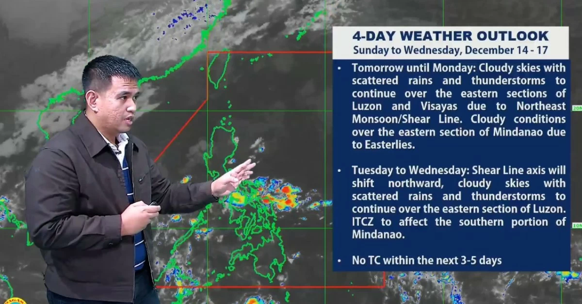
From Sunday to Monday (December 14 to 15), PAGASA said the shear line will continue to bring rains over Bicol, Eastern Visayas, Laguna, Rizal, Quezon, Oriental Mindoro, Marinduque, and Romblon, while “amihan” will bring cloudy skies with rains over Cagayan Valley and Aurora, and isolated light rains over Metro Manila and the rest of Central and Northern Luzon.
From Tuesday to Wednesday (December 16 to 17), the shear line is expected to shift northward, affecting eastern Luzon, while the intertropical convergence zone (ITCZ) may bring rains to southern Mindanao.
From Thursday to Friday (December 18 to 19), cloudy skies with scattered rains will persist over Bicol, Eastern Visayas, Quezon, Cagayan Valley, and the Cordillera Administrative Region, while Metro Manila and most of the country will continue to experience partly cloudy to cloudy skies with brief rain showers.
PAGASA said the weather outlook will be updated through daily public weather forecasts and advisories should there be significant changes in the forecast scenario.