


Manila Bulletin
 Philippines
National
Typhoon Verbena exits PAR; heavy rains persist in parts of Northern Luzon due to shear line
Philippines
National
Typhoon Verbena exits PAR; heavy rains persist in parts of Northern Luzon due to shear line
Philippines
National
Typhoon Verbena exits PAR; heavy rains persist in parts of Northern Luzon due to shear line
Typhoon Verbena exits PAR; heavy rains persist in parts of Northern Luzon due to shear line
Published Nov 27, 2025 10:41 am


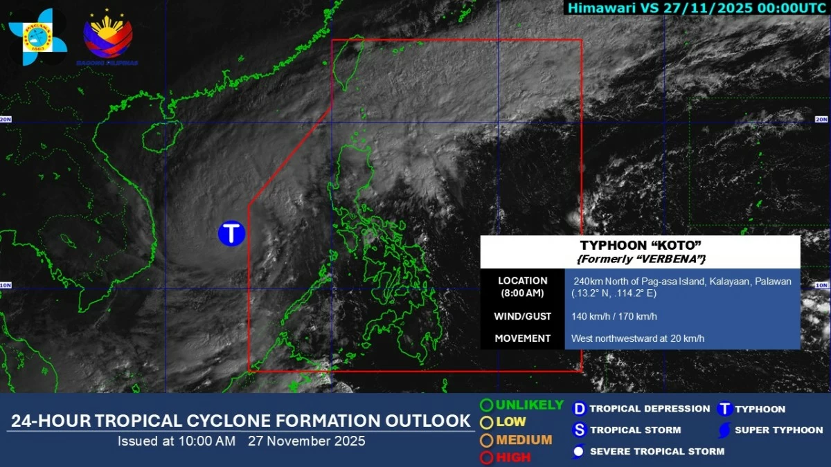
Satellite image of Typhoon Verbena (Koto) (Courtesy of PAGASA)
Typhoon Verbena (international name: Koto) exited the Philippine Area of Responsibility (PAR) early Thursday morning, Nov. 27, the Philippine Atmospheric, Geophysical and Astronomical Services Administration (PAGASA) said.
As of 8 a.m., the typhoon was located 240 kilometers north of Pag-asa Island, Palawan, with maximum sustained winds of 140 kilometers per hour (kph) near the center and gusts of up to 170 kph.
Verbena has been upgraded from a severe tropical storm to a typhoon and is moving west-northwestward at 20 kph.
Tropical Cyclone Wind Signal No. 1 remains in effect over Kalayaan Islands as strong winds may still prevail over the area.
Despite the typhoon’s exit, heavy rains continue over parts of Northern Luzon due to the shear line, a weather system formed by the collision of cold northeasterly winds, or amihan, and warm easterly winds.
PAGASA said 100 to 200 millimeters of rainfall (heavy to intense) may persist in Cagayan, and 50 to 100 millimeters of rainfall (moderate to heavy) over Apayao, Kalinga, and Isabela on Thursday.
“Yung mga kababayan natin dito sa Northern Luzon, ilang araw na rin po tayong nakakaranas ng sunod-sunod na ulan kaya ibayong pag-iingat pa rin po lalo na saturated na ang ating mga kalupaan, so mataas na ang tyansa ng pagbaha pati na rin ng pagguho ng lupa (Our fellow residents in Northern Luzon have been experiencing consecutive days of rainfall, so extra caution is needed as the ground is already saturated, increasing the risk of floods and landslides),” PAGASA weather specialist Chenel Dominguez said.
On Friday, Nov. 28, the effects of the shear line are expected to slightly weaken, but moderate to heavy rains will persist in Apayao, Kalinga, and Isabela.
Over the next 24 hours, amihan will bring cloudy skies with rains over Ilocos Region and the rest of Cordillera Administrative Region and Cagayan Valley.
Meanwhile, easterlies, or warm winds from the Pacific Ocean, will bring cloudy skies with scattered rains and thunderstorms over Aurora and Quezon.
Metro Manila and the rest of the country can expect partly cloudy to cloudy skies with isolated rain showers or localized thunderstorms.